Version 1.4.0 - December, 2023.
This page provides details about enhancements, deprecations, resolved issues, and known issues in the 1.4 release of ArcGIS Maps SDK for Unity.
Enhancements
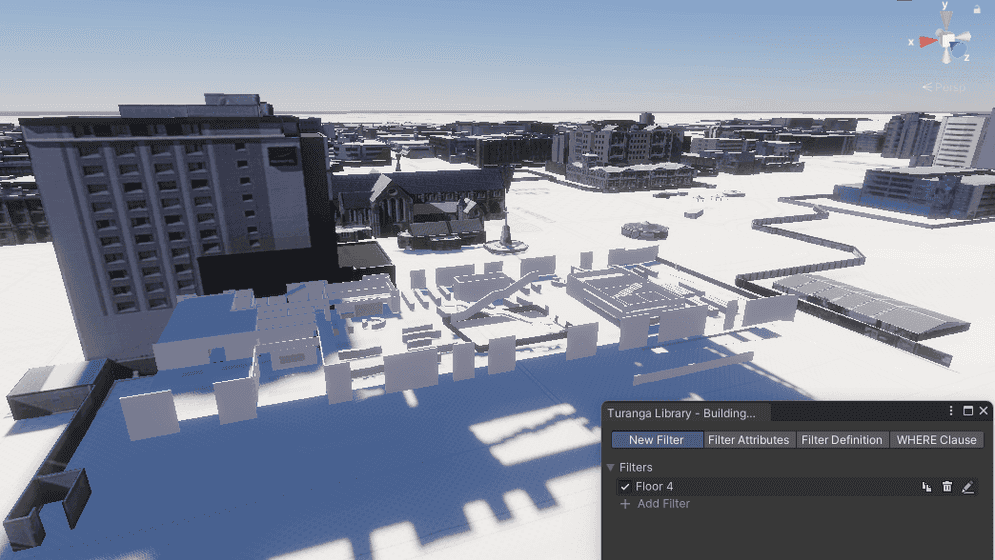
Building scene layer filtering
With this release, you can now filter building scene layers by creating custom attribute filters with SQL WHERE clauses. Building scene layers enable you to view one or more building models together in their spatial context and to work with the component parts of these buildings by querying and filtering different aspects. Building content is often derived from Building Information Modeling (BIM) workflows in design and construction. BIM processes can produce 3D virtual representations of real-world assets that are commonly used for construction, documentation, and evaluation of structures.
The ability to visualize building scene layers and work with sublayers was available in a previous release. With the improved level of detail available in these models, however, you may want to interactively filter elements or parts of a building scene layer to see only those aspects that relate to your work. For example, you may want to see only the second floor of a building, show only the load-bearing walls, or view only the electrical system. As a developer using either the Unity Map Creator UI low-code/no-code tools or programming with the API, you can support these user requirements by applying a filter to a building scene layer. Filters give you access to the underlying structure of a building scene layer including the discipline—such as Architectural, the categories—such as walls, and custom queries that filter elements based on their attribute values—such as by material type or manufacturer. Building scene layer filtering is available in the Unity Map Creator UI with new Building Filter and Disciplines and Categories options in the Layers tab.
Spatial filtering and mesh modification
With this release, the ability to spatially filter scene layers and modify meshes can now be accessed through a new UI in the Unity Editor. The new UI tools enable you to interactively draw and modify polygon areas to be applied as spatial filters for 3D object scene layers and building scene layers, and applied as mesh modifications for integrated mesh scene layers and elevation surface. The ability to spatially filter scene layers and modify meshes was available in a previous release, but only when using the API, and only on supported desktop platforms (macOS and Windows). This feature can now also be included in applications deployed on Android and iOS mobile platforms.
Another valuable addition to mesh modifications is the new ability to apply a constant elevation value to polygon areas you have defined, avoiding the need to replace these with an existing terrain dataset. A corresponding new modification type, replace has been added, enabling you to apply a new constant value to the specified area and specify a new altitude.
C# API
- A list of basemap style enum values has been added to the
ArcGISBasemap, including:Style - ArcGISHumanGeography
- ArcGISHumanGeographyBase
- ArcGISHumanGeographyDetail
- ArcGISHumanGeographyLabels
- ArcGISHumanGeographyDark
- ArcGISHumanGeographyDarkBase
- ArcGISHumanGeographyDarkDetail
- ArcGISHumanGeographyDarkLabels
- OSMBlueprint
- OSMHybrid
- OSMHybridDetail
- OSMNavigation
- OSMNavigationDark
Fetchmethod has been added to theStatistics Async ArcGISBuildingclass.Scene Layer ArcGISBuildingclass has been added to define a set of conditions that can be used to show or hide components in a building scene layer.Attribute Filter ArcGISSolidclass has been added to define which building components should be viewed as solid in the associatedBuilding Filter Definition ArcGISBuilding.Scene Layer ArcGISBuildinghas been added to invoke the callback when theScene Layer Active Building Attribute Filter Changed Event ArcGISBuildingchanges.Scene Layer.Active Building Attribute Filter ArcGISBuildingclass has been added to summarize statistics for an individual attribute field in anScene Layer Attribute Statistics ArcGISBuilding.Scene Layer - A new type of mesh modification,
Replace, has been added to theArcGISMeshenums.Modification Type
Plugin samples
- The 3D attributes sample and the ArcGIS hit test sample have been moved to the GitHub sample repo. (The 3D attributes sample has been renamed to Material By Attribute.)
Deprecations
There are no OS and framework deprecations with this release.
Issues resolved
-
Unable to compile Unity projects (with
Sample Contentimported) due to the samples assembly definition file missing a reference.Summary: The ArcGIS Camera Controller component in the
Sample Contentcauses compile errors when the Active Input Handling in the Project Settings is set to Input System Package (New) or Both due to the samples assembly definition file (.asmdef) missing a reference toUnity.Input.System -
Repeating textures not mapped correctly for 3D object scene layers.
Summary: 3D object scene layers that have repeating textures with UV mapping but no geometryUVRegion are rendered with a repeating edge of the texture instead of repeating the full texture.
-
Fully transparent materials are rendered with some artifacts with the Unity 2022 Universal Render Pipeline.
Summary: Scene nodes with full transparency are rendered with artifacts due to the alpha component not being used correctly with the Unity 2022 Universal Render Pipeline.
-
Cannot deselect the original tiles or select new tiles while selecting a group of tiles in the Scene view.
Summary: While selecting a group of tiles in the Scene view by holding the
Shiftkey, atransform.localerror message is logged in the Console window. Once the errors occur, you cannot select anything else until you restart Unity; attempting to press play causes Unity to crash.Position assign attempt for ... -
One image tile layer is still visible in the Scene view window even after removing all during the editor mode.
Summary: One image tile layer remains visible after removing all the image tile layers in the level.
-
The layer management popup of the Map Creator UI stays visible.
Summary: The layer management popup of the Map Creator UI stays visible even after clicking outside of it.
-
The default layer opacity is set to
0instead of1in the ArcGIS Map component.Summary: When you add the first array element in the Layers section or the ArcGIS Map component, the default layer opacity is set to
0instead of1.
Known issues
-
A basemap that fails to load will cause all layers in the ArcGIS Map to fail to display.
Summary: If you are using a basemap that fails to load (for example, a preset basemap that requires an API Key, but no API Key is set) then the loading of the ArcGIS Map will be interrupted and it will appear blank. This also impacts the SDK samples that use a preset basemap.
Workaround: Be sure to set an API key when using one of the preset basemaps.
-
View state report propagated warning messages
Summary: When you subscribe to error messages by using the view state report,
propagated errormessages are logged in the Console although it's not an error.Workaround: No workaround available.
-
Changes on the component not reflected in the Map Creator UI.
Summary: After making changes to the component, the Map Creator UI does not automatically update with the new values.
Workaround: Click a different tab in the Map Creator UI to pull the new values from the component.
-
The extent dimension values are incorrectly applied in the scene when the extent center is away from the Equator.
Summary: When you set an extent in the area away from the Equator in an ArcGIS Map with a geographic coordinate system, the shape dimension is bigger than the values set for the extension.
Workaround: No workaround available.
-
Setting opacity to scene layers has no effect.
Summary: Opacity does not work if the Unity material for the scene layer is opaque.
Workaround: Change the scene layer material to the one that has transparency.
-
Some parts of integrated mesh scene layers flash while navigating around the area.
Summary: When elevation is enabled in the scene, some parts of the integrated mesh scene layers flash.
Workaround: Disable the elevation.
-
Mesh collider/Terrain occlusion issue
Summary: When using an integrated mesh layer that dips below the elevation, although the terrain is occluded, the collider still exists which in some edge cases can make objects float above the integrated mesh.
Workaround: No workaround available.
-
Integrated mesh scene layer behind terrain relief is rendered with URP.
Summary: When an integrated mesh scene layer is behind terrain such as behind a mountain, the layer is visible.
Workaround: No workaround available.
-
Custom basemaps disappear from the basemap gallery after entering the play mode.
Summary: After adding custom basemaps from the Map Creator UI, click play once removes all custom basemaps that are not currently selected.
Workaround: No workaround available.
-
Custom basemap name will be lost after clicking play.
Summary: The name for the custom basemap that is added from the Map Creator UI is automatically changed to User Basemap after clicking play.
Workaround: No workaround available.
-
Error messages display in the Unity console after installing the SDK plugin.
Summary: An error message of
[fileanme] has no meta file, but it's in an immutable folder. The asset will be ignoreddisplays in the Unity Console after adding the SDK plugin to the Unity project with Unity version 2021.3.22 or below.Workaround: Update your Unity minor version. For example, from 2021.3.11 to 2021.3.24.
-
Local file packages cannot be added from the ArcGIS Map component using the ellipsis menu (three dots icon).
Summary: Adding local file packages from the ArcGIS Map component using the ellipsis menu does not add the file path to the Source field, and an
Invalidmessage is logged in the Unity Console.Operation Exception: Stack empty Workaround: Set the file path manually in the Source field. For example:
C:/Users/my_.username/my_ folder/example.slpk -
Some parts of meshes are missing when there are overwrapping polygon areas with the
Replacemesh modification type.Summary: When two overlapping mesh modifications of type replace are created on the elevation surface, the overlapping region is not rendered.
Workaround: No workaround available.
-
In the Add New Basemap dialog, all options in the drop-down lists are disabled when using Unity 2021 versions earlier than Unity 2021.3.33f1 on macOS.
Summary: When using Unity 2021 versions earlier than 2021.3.33f1 on macOS, it is not possible to select Type and Authentication in the Add New Basemap pop-up window opened from the Map Creator UI.
Workaround: Use a higher Unity 2021 version (e.g. Unity 2021.3.33f1).
-
Some parts of the mesh are missing or have bad LOD for the area with the
replacemesh modification type.Summary: For the flattened area with a new z value where the
replacemesh modification type is used, some parts of the mesh are missing or have low LOD depending on the camera position.Workaround: No workaround available.
-
Scene layer mesh normals are inconsistent with the Universal Render Pipeline.
Summary: Scene layers with inconsistent normals in the data are not rendered correctly.
Workaround: No workaround available.
-
Changing building scene layer opacity doesn't apply in play mode
Summary: After you change building scene layer opacity and hit play, the opacity value gets lost.
Workaround: No workaround available.
-
Moving the scene camera by clicking the Zoom to Layer option doesn't have any effect.
Summary: When the layer source is an item page URL, clicking the Zoom to Layer option doesn't move the scene camera.
Workaround: Use the service URL instead of the item page URL as the layer source.
-
Plugin samples can't be imported into a Unity project if the ArcGIS Maps SDK for Unity plugin is downloaded from the Unity Asset Store.
Summary: When the plugin is downloaded from the Unity Asset Store, users can't import the plugin sample to their Unity projects when the "Import" button is clicked.
Workaround: No workaround available. Use the tarball version of the plugin from the Downloads page to import the plugin sample.