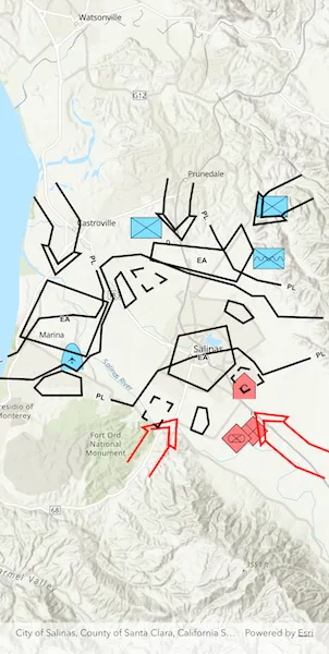
Convert features into graphics to show them with mil2525d symbols.
Use case
A dictionary renderer uses a style file along with a rule engine to display advanced symbology. This is useful for displaying features using precise military symbology.
How to use the sample
Pan and zoom around the map. Observe the displayed military symbology on the map.
How it works
- Create a
GeodatabaseusingGeodatabase.withFileUri(). - Load the geodatabase using
Geodatabase.load(). - Instantiate a
DictionarySymbolStyleusingDictionarySymbolStyle.withFileUri(). - Load the dictionary symbol style using
DictionarySymbolStyle.load(). - Cycle through each
GeodatabaseFeatureTablefrom the geodatabase usingGeodatabase.geodatabaseFeatureTables. - Create a
FeatureLayerfrom each table within the geodatabase usingFeatureLayer.withFeatureTable(). - Create a
DictionaryRendererand assign it to each feature layer usingfeatureLayer.renderer = dictionaryRenderer. - Add the feature layers to the map using
ArcGISMap.operationalLayers.addAll(). - Load the feature layers with
FeatureLayer.load(). - After the layers have loaded, create a new extent from the union of all layer extents.
- Set that extent as the map view viewpoint using
ArcGISMapViewController.setViewpoint().
Relevant API
- DictionaryRenderer
- DictionarySymbolStyle
Offline data
This sample uses the mil2525d stylx file and the military overlay geodatabase. They are downloaded from ArcGIS Online as part of the sample.
Tags
military, symbol
Sample code
apply_dictionary_renderer_to_feature_layer.dart
// Copyright 2026 Esri//// Licensed under the Apache License, Version 2.0 (the "License");// you may not use this file except in compliance with the License.// You may obtain a copy of the License at////   https://www.apache.org/licenses/LICENSE-2.0//// Unless required by applicable law or agreed to in writing, software// distributed under the License is distributed on an "AS IS" BASIS,// WITHOUT WARRANTIES OR CONDITIONS OF ANY KIND, either express or implied.// See the License for the specific language governing permissions and// limitations under the License.//
import 'dart:io';
import 'package:arcgis_maps/arcgis_maps.dart';import 'package:arcgis_maps_sdk_flutter_samples/common/common.dart';import 'package:flutter/material.dart';import 'package:go_router/go_router.dart';
class ApplyDictionaryRendererToFeatureLayer extends StatefulWidget {  const ApplyDictionaryRendererToFeatureLayer({super.key});
  @override  State<ApplyDictionaryRendererToFeatureLayer> createState() =>      _ApplyDictionaryRendererToFeatureLayerState();}
class _ApplyDictionaryRendererToFeatureLayerState    extends State<ApplyDictionaryRendererToFeatureLayer>    with SampleStateSupport {  // Create a controller for the map view.  final _mapViewController = ArcGISMapView.createController();
  @override  Widget build(BuildContext context) {    return Scaffold(      // Add a map view to the widget tree and set a controller.      body: ArcGISMapView(        controllerProvider: () => _mapViewController,        onMapViewReady: onMapViewReady,      ),    );  }
  Future<void> onMapViewReady() async {    // Create file references for the dictionary style and geodatabase.    final listPaths = GoRouter.of(context).state.extra! as List<String>;    final styleFile = File(listPaths.first);    final geodatabaseFile = File(listPaths.last);
    // Create the map and assign it to the map view controller.    final map = ArcGISMap.withBasemapStyle(BasemapStyle.arcGISTopographic);    _mapViewController.arcGISMap = map;
    // Open the geodatabase that contains the military overlay features.    final geodatabase = Geodatabase.withFileUri(geodatabaseFile.uri);    await geodatabase.load();
    // Load the dictionary symbol style from the local stylx file.    final dictionarySymbolStyle = DictionarySymbolStyle.withFileUri(      styleFile.uri,    );    await dictionarySymbolStyle.load();
    // Create a feature layer for each table in the geodatabase.    final featureLayers = <FeatureLayer>[];    for (final table in geodatabase.geodatabaseFeatureTables) {      final featureLayer = FeatureLayer.withFeatureTable(table);
      // Apply a dictionary renderer so the layer uses military symbols.      featureLayer.renderer = DictionaryRenderer(        dictionarySymbolStyle: dictionarySymbolStyle,      );      featureLayer.minScale = 1000000;
      featureLayers.add(featureLayer);    }
    // Add all of the feature layers to the map.    map.operationalLayers.addAll(featureLayers);
    // Load the layers so their content and extents are available.    await Future.wait(featureLayers.map((layer) => layer.load()));
    // Build a combined extent from all loaded feature layers.    final envelopeBuilder = EnvelopeBuilder(      spatialReference: SpatialReference.wgs84,    );    featureLayers        .map((layer) => layer.fullExtent)        .nonNulls        .forEach(envelopeBuilder.unionWithEnvelope);
    // Set the map viewpoint so all rendered features are visible.    _mapViewController.setViewpoint(      Viewpoint.fromTargetExtent(envelopeBuilder.extent),    );  }}