Use a custom dictionary style created from a web style or local style file (.stylx) to symbolize features using a variety of attribute values.
Use case
When symbolizing geoelements in your map, you may need to convey several pieces of information with a single symbol. You could try to symbolize such data using a unique value renderer, but as the number of fields and values increases, that approach becomes impractical. With a dictionary renderer you can build each symbol on-the-fly, driven by one or more attribute values, and handle a nearly infinite number of unique combinations.
How to use the sample
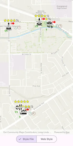
Use the segmented buttons to toggle between the dictionary symbols from the web style and style file. Pan and zoom around the map to see the symbology from the chosen dictionary symbol style. The web style and style file are slightly different to each other to give a visual indication of the switch between the two.
How it works
- Add the restaurant feature layer to the map’s
operationalLayerslist. - Create a
DictionaryRendererusingDictionarySymbolStyle.withFileUri(styleFileUri)with a local stylx file. - Create a
DictionaryRendererusingDictionarySymbolStyle.withPortalItem(portalItem)with aPortalItem, referring to aPortaland the item ID of the web style. - Based on the style selected, load the corresponding
DictionaryRendererby setting the feature layer’srendererproperty.
Relevant API
- DictionaryRenderer
- DictionarySymbolStyle
- Portal
- PortalItem
About the data
The data used in this sample is from a feature layer showing a subset of restaurants in Redlands, CA hosted as a feature service with attributes for rating, style, health score, and open hours.
The feature layer is symbolized using a dictionary renderer that displays a single symbol for all of these variables. The renderer uses symbols from a custom restaurant dictionary style created from a stylx file and a web style, available as items from ArcGIS Online, to show unique symbols based on several feature attributes. The symbols it contains were created using ArcGIS Pro. The logic used to apply the symbols comes from an Arcade script embedded in the stylx file (which is a SQLite database), along with a JSON string that defines expected attribute names and configuration properties.
Additional information
For information about creating your own custom dictionary style, see the open source dictionary renderer toolkit on GitHub.
Tags
dictionary, military, portal, portal item, renderer, style, stylx, unique value, visualization
Sample code
// Copyright 2026 Esri//// Licensed under the Apache License, Version 2.0 (the "License");// you may not use this file except in compliance with the License.// You may obtain a copy of the License at////   https://www.apache.org/licenses/LICENSE-2.0//// Unless required by applicable law or agreed to in writing, software// distributed under the License is distributed on an "AS IS" BASIS,// WITHOUT WARRANTIES OR CONDITIONS OF ANY KIND, either express or implied.// See the License for the specific language governing permissions and// limitations under the License.//
import 'package:arcgis_maps/arcgis_maps.dart';import 'package:arcgis_maps_sdk_flutter_samples/common/common.dart';import 'package:flutter/material.dart';import 'package:go_router/go_router.dart';
class StyleFeaturesWithCustomDictionary extends StatefulWidget {  const StyleFeaturesWithCustomDictionary({super.key});
  @override  State<StyleFeaturesWithCustomDictionary> createState() =>      _StyleFeaturesWithCustomDictionaryState();}
class _StyleFeaturesWithCustomDictionaryState    extends State<StyleFeaturesWithCustomDictionary>    with SampleStateSupport {  // Create a controller for the map view.  final _mapViewController = ArcGISMapView.createController();
  // A feature layer showing restaurants in Redlands, CA.  late final FeatureLayer _restaurantFeatureLayer;
  // Renderers for each of the dictionary renderer style options.  final _rendererForStyle = <_RendererStyle, DictionaryRenderer>{};
  // The currently selected style.  var _selectedStyle = _RendererStyle.styleFile;
  // A flag for when the map view is ready and controls can be used.  var _ready = false;
  @override  Widget build(BuildContext context) {    return Scaffold(      body: SafeArea(        top: false,        left: false,        right: false,        child: Stack(          children: [            Column(              children: [                Expanded(                  // Add a map view to the widget tree and set a controller.                  child: ArcGISMapView(                    controllerProvider: () => _mapViewController,                    onMapViewReady: onMapViewReady,                  ),                ),                // Add a segmented button to switch between "Style File" and "Web Style" options.                SegmentedButton(                  segments: _RendererStyle.values                      .map(                        (style) => ButtonSegment(                          value: style,                          label: Text(style.label),                        ),                      )                      .toList(),                  selected: {_selectedStyle},                  onSelectionChanged: (selection) {                    setState(() => _selectedStyle = selection.first);                    _restaurantFeatureLayer.renderer =                        _rendererForStyle[_selectedStyle];                  },                ),              ],            ),            // Display a progress indicator and prevent interaction until state is ready.            LoadingIndicator(visible: !_ready),          ],        ),      ),    );  }
  void onMapViewReady() {    // Create a map with a topographic basemap style and initial viewpoint.    final map = ArcGISMap.withBasemapStyle(BasemapStyle.arcGISTopographic)      ..initialViewpoint = Viewpoint.withLatLongScale(        latitude: 34.0543,        longitude: -117.1963,        scale: 10000,      );    _mapViewController.arcGISMap = map;
    // Prepare a feature layer with restaurants in Redlands, CA.    _restaurantFeatureLayer = FeatureLayer.withFeatureTable(      ServiceFeatureTable.withUri(        Uri.parse(          'https://services2.arcgis.com/ZQgQTuoyBrtmoGdP/arcgis/rest/services/Redlands_Restaurants/FeatureServer/0',        ),      ),    );    map.operationalLayers.add(_restaurantFeatureLayer);
    // Prepare a DictionaryRenderer with the style file that was downloaded and stored locally.    final listPaths = GoRouter.of(context).state.extra! as List<String>;    final styleFileUri = Uri.file(listPaths.first);    _rendererForStyle[.styleFile] = DictionaryRenderer(      dictionarySymbolStyle: DictionarySymbolStyle.withFileUri(styleFileUri),    );
    // Prepare a DictionaryRenderer with a web style from ArcGIS Online.    final portalItem = PortalItem.withPortalAndItemId(      portal: Portal.arcGISOnline(),      itemId: 'adee951477014ec68d7cf0ea0579c800',    );    _rendererForStyle[.webStyle] = DictionaryRenderer(      dictionarySymbolStyle: DictionarySymbolStyle.withPortalItem(portalItem),      // This style uses the "Inspection" field to symbolize health grades.      symbologyFieldOverrides: {'healthgrade': 'Inspection'},    );
    // Set the selected renderer on the feature layer.    _restaurantFeatureLayer.renderer = _rendererForStyle[_selectedStyle];
    // Set the ready state variable to true to enable the sample UI.    setState(() => _ready = true);  }}
// An enum to represent the different renderer style options.enum _RendererStyle {  styleFile('Style File'),  webStyle('Web Style');
  const _RendererStyle(this.label);
  final String label;}