Create symbol styles from a style file hosted on a portal.
Use case
Style files hosted on an ArcGIS Online or Enterprise portal are known as web styles. They can be used to style symbols on a feature layer or graphic overlay. Since styles are published from ArcGIS Pro, you can author and design your own beautiful multilayer vector symbols. These vector symbols look good at any resolution and scale well. Maps SDK users can now access these styles from their native application, and make use of the vector symbols within them to enhance features and graphics in the map.
How to use the sample
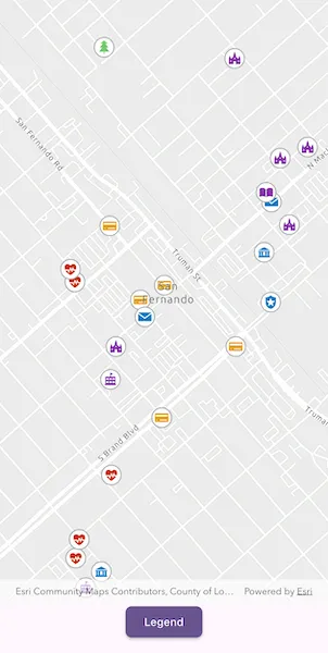
The sample displays a map with a set of symbols that represent the categories of the features within the dataset. Pan and zoom on the map and view the legend to explore the appearance and names of the different symbols from the selected symbol style.
How it works
- Create a
FeatureLayerand add it to the map. - Create a
SymbolStylefrom a portal by passing in the web style name and portal URL. * Note: passingnullas the portal will default to ArcGIS.com. - Search for symbols in the symbol style by name using
symbolStyle.getSymbol(). - Create an
ArcGISSymbolfrom the search result. - Create
UniqueValueobjects for each symbol with defined values to map the symbol to features on the feature layer. - Create a
UniqueValueRendererwith theUniqueValueobjects and set it to the feature layer.
Relevant API
- ArcGISSymbol
- FeatureLayer
- SymbolStyle
- UniqueValue
- UniqueValueRenderer
About the data
The sample uses the ‘Esri2DPointSymbolsStyle’ Web Style.
The map shows features from the LA County Points of Interest service hosted on ArcGIS Online.
Additional information
2D web styles, dictionary web styles, and 3D web styles can all be hosted on an ArcGIS Online or Enterprise portal.
Tags
renderer, symbol, symbology, web style
Sample code
// Copyright 2026 Esri//// Licensed under the Apache License, Version 2.0 (the "License");// you may not use this file except in compliance with the License.// You may obtain a copy of the License at////   https://www.apache.org/licenses/LICENSE-2.0//// Unless required by applicable law or agreed to in writing, software// distributed under the License is distributed on an "AS IS" BASIS,// WITHOUT WARRANTIES OR CONDITIONS OF ANY KIND, either express or implied.// See the License for the specific language governing permissions and// limitations under the License.//
import 'dart:async';
import 'package:arcgis_maps/arcgis_maps.dart';import 'package:arcgis_maps_sdk_flutter_samples/common/common.dart';import 'package:flutter/material.dart';
class CreateSymbolStylesFromWebStyles extends StatefulWidget {  const CreateSymbolStylesFromWebStyles({super.key});
  @override  State<CreateSymbolStylesFromWebStyles> createState() =>      _CreateSymbolStylesFromWebStylesState();}
class _CreateSymbolStylesFromWebStylesState    extends State<CreateSymbolStylesFromWebStyles>    with SampleStateSupport {  // Create a controller for the map view.  final _mapViewController = ArcGISMapView.createController();
  // A feature layer with the LA County points of interest service.  late final FeatureLayer _featureLayer;
  // The list of legend items shown in the legend sheet.  final _legendItems = <_LegendItem>[];
  // A subscription used to react to map scale changes.  StreamSubscription<double>? _scaleChangedSubscription;
  // A flag for when the map view is ready and controls can be used.  var _ready = false;
  // A flag for when the legend bottom sheet is visible.  var _legendVisible = false;
  @override  void dispose() {    _scaleChangedSubscription?.cancel().ignore();    super.dispose();  }
  @override  Widget build(BuildContext context) {    return Scaffold(      body: SafeArea(        top: false,        left: false,        right: false,        child: Stack(          children: [            Column(              children: [                Expanded(                  // Add a map view to the widget tree and set a controller.                  child: ArcGISMapView(                    controllerProvider: () => _mapViewController,                    onMapViewReady: onMapViewReady,                  ),                ),                Row(                  mainAxisAlignment: .spaceEvenly,                  children: [                    // Show a legend sheet listing the symbol swatches and names.                    ElevatedButton(                      onPressed: () => setState(() => _legendVisible = true),                      child: const Text('Legend'),                    ),                  ],                ),              ],            ),            // Display a progress indicator and prevent interaction until state is ready.            LoadingIndicator(visible: !_ready),          ],        ),      ),      // Show the legend as a bottom sheet when the legend button is pressed.      bottomSheet: _legendVisible ? _buildLegendSheet(context) : null,    );  }
  Widget _buildLegendSheet(BuildContext context) {    return BottomSheetSettings(      title: 'Symbol Styles',      onCloseIconPressed: () => setState(() => _legendVisible = false),      settingsWidgets: (context) => [        ConstrainedBox(          constraints: BoxConstraints(            maxHeight: MediaQuery.sizeOf(context).height * 0.4,          ),          child: ListView.separated(            shrinkWrap: true,            itemCount: _legendItems.length,            separatorBuilder: (_, _) => const SizedBox(height: 8),            itemBuilder: (context, index) {              final item = _legendItems[index];              return ListTile(                leading: SwatchImage(                  symbol: item.symbol,                  width: 24,                  height: 24,                ),                title: Text(item.name),              );            },          ),        ),      ],    );  }
  Future<void> onMapViewReady() async {    // Create a map with a light gray basemap and a fixed reference scale.    final map = ArcGISMap.withBasemapStyle(.arcGISLightGray)      ..referenceScale = 1e5      ..initialViewpoint = Viewpoint.withLatLongScale(        latitude: 34.28301,        longitude: -118.44186,        scale: 10000,      );
    // Add the LA County Points of Interest feature layer to the map.    _featureLayer = FeatureLayer.withFeatureTable(      ServiceFeatureTable.withUri(        Uri.parse(          'https://services.arcgis.com/V6ZHFr6zdgNZuVG0/arcgis/rest/services/LA_County_Points_of_Interest/FeatureServer/0',        ),      ),    );    map.operationalLayers.add(_featureLayer);    _mapViewController.arcGISMap = map;
    // Prevent symbols from scaling when zoomed out too far.    _scaleChangedSubscription = _mapViewController.onScaleChanged.listen((      scale,    ) {      _featureLayer.scaleSymbols = scale >= 8e4;    });
    // Load the legend information.    await _loadLegend();
    // Set the ready state variable to true to enable the sample UI.    setState(() => _ready = true);  }
  Future<void> _loadLegend() async {    try {      // Load the "Esri2DPointSymbolsStyle" web style from ArcGIS Online.      final symbolStyle = SymbolStyle.withStyleName('Esri2DPointSymbolsStyle');
      // For each symbol type, prepare the symbol and associated category names.      final symbolDetails = await Future.wait(        _SymbolType.values.map((type) async {          final symbol = await symbolStyle.getSymbol([type.symbolName]);          return _SymbolDetail(            name: type.symbolName,            categoryNames: type.categoryNames,            symbol: symbol,          );        }),      );
      // Create a unique value renderer to render the symbols.      final uniqueValues = <UniqueValue>[];      for (final detail in symbolDetails) {        for (final category in detail.categoryNames) {          uniqueValues.add(            UniqueValue(              label: detail.name,              symbol: detail.symbol,              values: [category],            ),          );        }      }      final renderer = UniqueValueRenderer(        fieldNames: const ['cat2'],        uniqueValues: uniqueValues,      );
      // Set the renderer on the feature layer to apply the symbols to the map.      _featureLayer.renderer = renderer;
      // Create legend items of each symbol for display in the legend sheet.      final legendItems = symbolDetails          .map(            (symbolDetail) => _LegendItem(              name: symbolDetail.name,              symbol: symbolDetail.symbol,            ),          )          .toList();      legendItems.sort((a, b) => a.name.compareTo(b.name));      _legendItems.addAll(legendItems);    } on Exception catch (e) {      showMessageDialog('Error updating symbols: $e');    }  }}
// A class containing a symbol and associated category mappings.final class _SymbolDetail {  const _SymbolDetail({    required this.name,    required this.categoryNames,    required this.symbol,  });
  final String name;  final List<String> categoryNames;  final ArcGISSymbol symbol;}
// A class describing an item shown in the legend list.final class _LegendItem {  const _LegendItem({required this.name, required this.symbol});
  final String name;  final ArcGISSymbol symbol;}
// The symbol categories represented in the points of interest dataset.enum _SymbolType {  atm(symbolName: 'atm', categoryNames: ['Banking and Finance']),  beach(symbolName: 'beach', categoryNames: ['Beaches and Marinas']),  campground(symbolName: 'campground', categoryNames: ['Campgrounds']),  cityHall(    symbolName: 'city-hall',    categoryNames: ['City Halls', 'Government Offices'],  ),  hospital(    symbolName: 'hospital',    categoryNames: [      'Hospitals and Medical Centers',      'Health Screening and Testing',      'Health Centers',      'Mental Health Centers',    ],  ),  library(symbolName: 'library', categoryNames: ['Libraries']),  park(symbolName: 'park', categoryNames: ['Parks and Gardens']),  placeOfWorship(symbolName: 'place-of-worship', categoryNames: ['Churches']),  policeStation(    symbolName: 'police-station',    categoryNames: ['Sheriff and Police Stations'],  ),  postOffice(    symbolName: 'post-office',    categoryNames: ['DHL Locations', 'Federal Express Locations'],  ),  school(    symbolName: 'school',    categoryNames: [      'Public High Schools',      'Public Elementary Schools',      'Private and Charter Schools',    ],  ),  trail(symbolName: 'trail', categoryNames: ['Trails']);
  const _SymbolType({required this.symbolName, required this.categoryNames});
  final String symbolName;  final List<String> categoryNames;}