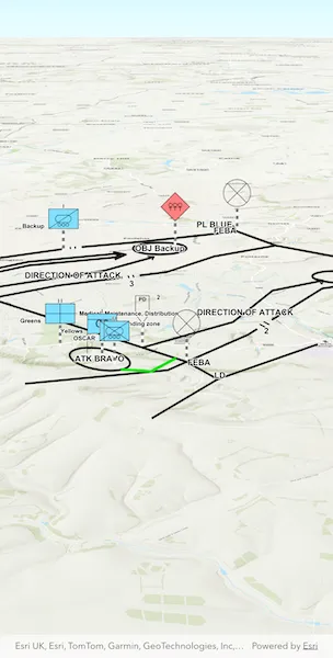
Create graphics from an XML file with key-value pairs for each graphic, and display the military symbols using a MIL-STD-2525D web style in 3D.
Use case
Use a dictionary renderer on a graphics overlay to display more transient data, such as military messages coming through a local tactical network.
How to use the sample
Run the sample and view the military symbols on the map.
How it works
- Create a new
DictionarySymbolStyleobject with the “mil2525d” specification type and set the style’s draw rule configuration to “ORDERED ANCHOR POINTS”. - Create a new
DictionaryRendererobject with the dictionary symbol style. - Create an instance of
GraphicsOverlay. - Set the dictionary renderer to the graphics overlay.
- Parse through the local XML file creating a map of key/value pairs for each block of attributes.
- Create an instance of
Graphicfor each attribute. - Use the
_wkidkey to get the geometry’s spatial reference. - Use the
_control_pointskey to get the geometry’s shape. - Add the graphic to the graphics overlay.
Relevant API
- DictionaryRenderer
- DictionarySymbolStyle
- GraphicsOverlay
About the data
The sample viewer will load MIL-STD-2525D symbol dictionary web style from ArcGIS Online before loading the sample. This ArcGIS Web Style is for use to build custom applications that incorporate the MIL-STD-2525D symbol dictionary. This style supports a configuration for modeling locations as ordered anchor points or full geometries.
A local XML file containing messages with MIL-STD-2525D fields for military symbology (MIL-STD-2525D Messages 100.13.0) is also used. This is downloaded from ArcGIS Online automatically.
Tags
defense, military, situational awareness, tactical, visualization
Sample code
// Copyright 2026 Esri//// Licensed under the Apache License, Version 2.0 (the "License");// you may not use this file except in compliance with the License.// You may obtain a copy of the License at////   https://www.apache.org/licenses/LICENSE-2.0//// Unless required by applicable law or agreed to in writing, software// distributed under the License is distributed on an "AS IS" BASIS,// WITHOUT WARRANTIES OR CONDITIONS OF ANY KIND, either express or implied.// See the License for the specific language governing permissions and// limitations under the License.//
import 'dart:io';
import 'package:arcgis_maps/arcgis_maps.dart';import 'package:arcgis_maps_sdk_flutter_samples/common/common.dart';import 'package:flutter/material.dart';import 'package:go_router/go_router.dart';import 'package:xml/xml.dart';
class ApplyDictionaryRendererToGraphicsOverlay extends StatefulWidget {  const ApplyDictionaryRendererToGraphicsOverlay({super.key});
  @override  State<ApplyDictionaryRendererToGraphicsOverlay> createState() =>      _ApplyDictionaryRendererToGraphicsOverlayState();}
class _ApplyDictionaryRendererToGraphicsOverlayState    extends State<ApplyDictionaryRendererToGraphicsOverlay>    with SampleStateSupport {  // Create a controller for the scene view.  final _sceneViewController = ArcGISSceneView.createController();
  // The graphics overlay for displaying the message graphics on the scene.  final _graphicsOverlay = GraphicsOverlay();
  // A flag for when the scene view is ready and controls can be used.  var _ready = false;
  @override  Widget build(BuildContext context) {    return Scaffold(      body: Stack(        children: [          // Add a scene view to the widget tree and set a controller.          ArcGISSceneView(            controllerProvider: () => _sceneViewController,            onSceneViewReady: onSceneViewReady,          ),          // Display a progress indicator and prevent interaction until state is ready.          LoadingIndicator(visible: !_ready),        ],      ),    );  }
  Future<void> onSceneViewReady() async {    // Create a scene with a topographic basemap style.    final scene = ArcGISScene.withBasemapStyle(.arcGISTopographic);    _sceneViewController.arcGISScene = scene;
    // Set the dictionary renderer on the overlay.    _graphicsOverlay.renderer = await getMIL2525DRenderer();
    // Parse the MIL-STD-2525D XML and add graphics to the overlay.    final graphics = await generateMessageGraphics();    _graphicsOverlay.graphics.addAll(graphics);
    // Attach the overlay to the scene view.    _sceneViewController.graphicsOverlays.add(_graphicsOverlay);
    // Set a viewpoint camera to the scene view using the extent of the graphics overlay.    final extent = _graphicsOverlay.extent;    if (extent != null) {      final camera = Camera.withLookAtPoint(        lookAtPoint: extent.center,        distance: 15000,        heading: 0,        pitch: 70,        roll: 0,      );      _sceneViewController.setViewpointCamera(camera);    }
    // Set the ready state variable to true to enable the sample UI.    setState(() => _ready = true);  }
  // Creates a dictionary renderer for styling with MIL-STD-2525D symbols.  Future<DictionaryRenderer> getMIL2525DRenderer() async {    // Create a dictionary symbol style from a dictionary style portal item.    final portalItem = PortalItem.withPortalAndItemId(      portal: Portal.arcGISOnline(),      itemId: 'd815f3bdf6e6452bb8fd153b654c94ca',    );    final dictionarySymbolStyle = DictionarySymbolStyle.withPortalItem(      portalItem,    );    await dictionarySymbolStyle.load();
    // Use the "Ordered Anchor Points" for the symbol style draw rule.    final drawRuleConfiguration = dictionarySymbolStyle.configurations        .firstWhere((item) => item.name == 'model');    drawRuleConfiguration.value = 'ORDERED ANCHOR POINTS';
    return DictionaryRenderer(dictionarySymbolStyle: dictionarySymbolStyle);  }
  // Load and create message graphics.  Future<List<Graphic>> generateMessageGraphics() async {    // Create file reference for the MIL-STD-2525D XML File.    final listPaths = GoRouter.of(context).state.extra! as List<String>;    final mil2525XMLFile = File(listPaths.first);
    // Read the XML as a string and parse it into a list of Message objects.    final xmlString = await mil2525XMLFile.readAsString();    final parser = _MessageParser()..parse(xmlString);
    // Convert each parsed message into a Graphic.    return parser.messages        .map<Graphic?>((message) {          final wkid = message.wkid;          // Skip messages without a usable WKID.          if (wkid == null) return null;
          final spatialReference = SpatialReference(wkid: wkid);          final builder = MultipointBuilder(spatialReference: spatialReference);          for (final coord in message.controlPoints) {            builder.points.addPointXY(x: coord.x, y: coord.y);          }          final multipoint = builder.toGeometry() as Multipoint;
          return Graphic(geometry: multipoint, attributes: message.other);        })        .nonNulls        .toList(growable: false);  }}
/// The parsed values from a single `<message>` element of the XML file.class _Message {  /// The x and y values from the `<_control_points>` element.  List<({double x, double y})> controlPoints = [];
  /// The integer value of the `<_wkid>` element.  int? wkid;
  /// A map containing every other element name from the XML file mapped to its text content.  Map<String, String> other = {};}
/// A DOM-based XML parser for the MIL-STD-2525D messages file.class _MessageParser {  final List<_Message> messages = [];
  void parse(String xmlString) {    final document = XmlDocument.parse(xmlString);
    // Iterate every <message> element (children of the root <messages>).    for (final messageNode in document.findAllElements('message')) {      final message = _Message();
      for (final child in messageNode.childElements) {        final name = child.name.local;        final text = child.innerText;
        switch (name) {          case '_control_points':            // The text looks like "x1,y1;x2,y2;...".            message.controlPoints = text                .split(';')                .where((pair) => pair.contains(','))                .map((pair) {                  final parts = pair.split(',');                  return (                    x: double.parse(parts.first.trim()),                    y: double.parse(parts.last.trim()),                  );                })                .toList();          case '_wkid':            message.wkid = int.tryParse(text.trim());          default:            message.other[name] = text;        }      }
      messages.add(message);    }  }}