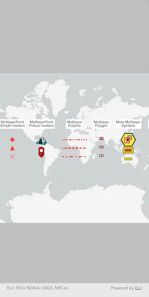
Show different kinds of multilayer symbols on a map similar to some pre-defined 2D simple symbol styles.
Use case
Allows you to customize a graphic with a multilayer symbol. For example, you may want more customizable symbols than the one that is provided with the API to display a unique representation of a landmark.
How to use the sample
The sample loads multilayer symbols for points, polylines, and polygons.
How it works
- Create multilayer symbols for each predefined 2D simple symbol style.
- For multilayer point symbols, use the
MultilayerPointSymbolconstructor. - For multilayer polyline symbols, use the
MultilayerPolylineSymbolconstructor. - For multilayer polygon symbols, use the
MultilayerPolygonSymbolconstructor.
- For multilayer point symbols, use the
- Create graphics by passing in a geometry and the associated symbol.
- Add graphics to the graphics overlay with
overlay.graphics.add(graphic)
Relevant API
- Graphic
- GraphicsOverlay
- MultilayerPointSymbol
- MultilayerPolygonSymbol
- MultilayerPolylineSymbol
- PictureMarkerSymbolLayer
- SolidFillSymbolLayer
- SolidStrokeSymbolLayer
- VectorMarkerSymbolLayer
About the data
The campsite picture marker symbol is constructed from a URL.

Tags
graphic, marker, multilayer, picture, symbol
Sample code
render_multilayer_symbols.dart
//// Copyright 2026 Esri//// Licensed under the Apache License, Version 2.0 (the "License");// you may not use this file except in compliance with the License.// You may obtain a copy of the License at////   https://www.apache.org/licenses/LICENSE-2.0//// Unless required by applicable law or agreed to in writing, software// distributed under the License is distributed on an "AS IS" BASIS,// WITHOUT WARRANTIES OR CONDITIONS OF ANY KIND, either express or implied.// See the License for the specific language governing permissions and// limitations under the License.//
import 'package:arcgis_maps/arcgis_maps.dart';import 'package:arcgis_maps_sdk_flutter_samples/common/common.dart';import 'package:flutter/material.dart';
class RenderMultilayerSymbols extends StatefulWidget {  const RenderMultilayerSymbols({super.key});
  @override  State<RenderMultilayerSymbols> createState() =>      _RenderMultilayerSymbolsState();}
class _RenderMultilayerSymbolsState extends State<RenderMultilayerSymbols>    with SampleStateSupport {  // Create a controller for the map view.  final _mapViewController = ArcGISMapView.createController();
  @override  Widget build(BuildContext context) {    return Scaffold(      // Add a map view to the widget tree and set a controller.      body: ArcGISMapView(        controllerProvider: () => _mapViewController,        onMapViewReady: onMapViewReady,      ),    );  }
  void onMapViewReady() {    // Create a map with a light gray basemap style.    final map = ArcGISMap.withBasemapStyle(BasemapStyle.arcGISLightGray);    _mapViewController.arcGISMap = map;
    // Set an initial viewpoint covering the entire world.    map.initialViewpoint = Viewpoint.fromTargetExtent(      Envelope.fromPoints(        ArcGISPoint(x: -180, y: -90, spatialReference: SpatialReference.wgs84),        ArcGISPoint(x: 180, y: 90, spatialReference: SpatialReference.wgs84),      ),    );
    // Load the multilayer symbol graphics onto the map.    final overlay = createMultilayerGraphics();    _mapViewController.graphicsOverlays.add(overlay);  }
  // Helper method to create a simple text symbol for labeling the symbol categories.  TextSymbol labelSymbol(String text) {    return TextSymbol(text: text, size: 10)..backgroundColor = Colors.white;  }
  // Prepare a graphics overlay with graphics that demonstrate the various multilayer symbol types.  GraphicsOverlay createMultilayerGraphics() {    // A common offset value to use for separating the symbol layers in the display.    const offset = 20.0;
    // Create a graphics overlay to hold the multilayer symbol graphics.    final overlay = GraphicsOverlay();
    // MultilayerPoint - simple markers.    overlay.graphics.add(      Graphic(        geometry: ArcGISPoint(          x: -150,          y: 50,          spatialReference: SpatialReference.wgs84,        ),        symbol: labelSymbol('MultilayerPoint\nSimple markers'),      ),    );
    // A diamond.    final diamondGeometry = Geometry.fromJsonString(      '{"rings":[[[0.0,2.5],[2.5,0.0],[0.0,-2.5],[-2.5,0.0],[0.0,2.5]]]}',    );    final diamondElement = VectorMarkerSymbolElement(      geometry: diamondGeometry,      multilayerSymbol: MultilayerPolygonSymbol(        symbolLayers: [SolidFillSymbolLayer(color: Colors.red)],      ),    );    final diamondLayer = VectorMarkerSymbolLayer(      vectorMarkerSymbolElements: [diamondElement],    );    final diamondPointSymbol = MultilayerPointSymbol(      symbolLayers: [diamondLayer],    );    overlay.graphics.add(      Graphic(        geometry: ArcGISPoint(          x: -150,          y: 20,          spatialReference: SpatialReference.wgs84,        ),        symbol: diamondPointSymbol,      ),    );
    // A triangle.    final triangleGeometry = Geometry.fromJsonString(      '{"rings":[[[0.0,5.0],[5,-5.0],[-5,-5.0],[0.0,5.0]]]}',    );    final triangleElement = VectorMarkerSymbolElement(      geometry: triangleGeometry,      multilayerSymbol: MultilayerPolygonSymbol(        symbolLayers: [SolidFillSymbolLayer(color: Colors.red)],      ),    );    final triangleLayer = VectorMarkerSymbolLayer(      vectorMarkerSymbolElements: [triangleElement],    );    final trianglePointSymbol = MultilayerPointSymbol(      symbolLayers: [triangleLayer],    );    overlay.graphics.add(      Graphic(        geometry: ArcGISPoint(          x: -150,          y: 20 - offset,          spatialReference: SpatialReference.wgs84,        ),        symbol: trianglePointSymbol,      ),    );
    // An X shape.    final xGeometry = Geometry.fromJsonString(      '{"paths":[[[-1,1],[0,0],[1,-1]],[[1,1],[0,0],[-1,-1]]]}',    );    final xElement = VectorMarkerSymbolElement(      geometry: xGeometry,      multilayerSymbol: MultilayerPolylineSymbol(        symbolLayers: [SolidStrokeSymbolLayer(width: 1, color: Colors.red)],      ),    );    final xLayer = VectorMarkerSymbolLayer(      vectorMarkerSymbolElements: [xElement],    );    final xPointSymbol = MultilayerPointSymbol(symbolLayers: [xLayer]);    overlay.graphics.add(      Graphic(        geometry: ArcGISPoint(          x: -150,          y: 20 - (2 * offset),          spatialReference: SpatialReference.wgs84,        ),        symbol: xPointSymbol,      ),    );
    // MultilayerPoint - picture markers.    overlay.graphics.add(      Graphic(        geometry: ArcGISPoint(          x: -80,          y: 50,          spatialReference: SpatialReference.wgs84,        ),        symbol: labelSymbol('MultilayerPoint\nPicture markers'),      ),    );
    // Picture marker symbol from a URL.    final campsiteMarker = PictureMarkerSymbolLayer.withUri(      Uri.parse(        'https://static.arcgis.com/images/Symbols/OutdoorRecreation/Camping.png',      ),    )..size = 30;    final campsiteSymbol = MultilayerPointSymbol(      symbolLayers: [campsiteMarker],    );    overlay.graphics.add(      Graphic(        geometry: ArcGISPoint(          x: -80,          y: 20,          spatialReference: SpatialReference.wgs84,        ),        symbol: campsiteSymbol,      ),    );
    // Picture marker symbol from an asset.    ArcGISImage.fromAsset('assets/pin_circle_red.png').then((pinImage) {      final pinMarker = PictureMarkerSymbolLayer.withImage(pinImage)..size = 30;      final pinSymbol = MultilayerPointSymbol(symbolLayers: [pinMarker]);      overlay.graphics.add(        Graphic(          geometry: ArcGISPoint(            x: -80,            y: 20 - offset - 10,            spatialReference: SpatialReference.wgs84,          ),          symbol: pinSymbol,        ),      );    }).ignore();
    // Multilayer - polylines.    overlay.graphics.add(      Graphic(        geometry: ArcGISPoint(          x: 0,          y: 50,          spatialReference: SpatialReference.wgs84,        ),        symbol: labelSymbol('Multilayer\nPolyline'),      ),    );
    // Dash, dot, dot.    var polylineBuilder =        PolylineBuilder(spatialReference: SpatialReference.wgs84)          ..addPointXY(x: -30, y: 20)          ..addPointXY(x: 30, y: 20);    var stroke = SolidStrokeSymbolLayer(      width: 3,      color: Colors.red,      geometricEffects: [        DashGeometricEffect(dashTemplate: const [4, 6, 0.5, 6, 0.5, 6]),      ],    )..capStyle = StrokeSymbolLayerCapStyle.round;    overlay.graphics.add(      Graphic(        geometry: polylineBuilder.toGeometry(),        symbol: MultilayerPolylineSymbol(symbolLayers: [stroke]),      ),    );
    // Dashes.    polylineBuilder = PolylineBuilder(spatialReference: SpatialReference.wgs84)      ..addPointXY(x: -30, y: 20 - offset)      ..addPointXY(x: 30, y: 20 - offset);    stroke = SolidStrokeSymbolLayer(      width: 3,      color: Colors.red,      geometricEffects: [        DashGeometricEffect(dashTemplate: const [4, 6]),      ],    )..capStyle = StrokeSymbolLayerCapStyle.round;    overlay.graphics.add(      Graphic(        geometry: polylineBuilder.toGeometry(),        symbol: MultilayerPolylineSymbol(symbolLayers: [stroke]),      ),    );
    // Dash, dot.    polylineBuilder = PolylineBuilder(spatialReference: SpatialReference.wgs84)      ..addPointXY(x: -30, y: 20 - (2 * offset))      ..addPointXY(x: 30, y: 20 - (2 * offset));    stroke = SolidStrokeSymbolLayer(      width: 3,      color: Colors.red,      geometricEffects: [        DashGeometricEffect(dashTemplate: const [7, 9, 0.5, 9]),      ],    )..capStyle = StrokeSymbolLayerCapStyle.round;    overlay.graphics.add(      Graphic(        geometry: polylineBuilder.toGeometry(),        symbol: MultilayerPolylineSymbol(symbolLayers: [stroke]),      ),    );
    // Multilayer - polygons.    overlay.graphics.add(      Graphic(        geometry: ArcGISPoint(          x: 65,          y: 50,          spatialReference: SpatialReference.wgs84,        ),        symbol: labelSymbol('Multilayer\nPolygon'),      ),    );
    final hatchStroke = SolidStrokeSymbolLayer(width: 2, color: Colors.red);    final outlineStroke = SolidStrokeSymbolLayer(width: 1);
    // Cross-hatched diagonal lines.    var polygonBuilder =        PolygonBuilder(spatialReference: SpatialReference.wgs84)          ..addPointXY(x: 60, y: 25)          ..addPointXY(x: 70, y: 25)          ..addPointXY(x: 70, y: 20)          ..addPointXY(x: 60, y: 20);    final diagonalStroke1 = HatchFillSymbolLayer(      polylineSymbol: MultilayerPolylineSymbol(symbolLayers: [hatchStroke]),      angle: 45,    )..separation = 9;    final diagonalStroke2 = HatchFillSymbolLayer(      polylineSymbol: MultilayerPolylineSymbol(symbolLayers: [hatchStroke]),      angle: -45,    )..separation = 9;    overlay.graphics.add(      Graphic(        geometry: polygonBuilder.toGeometry(),        symbol: MultilayerPolygonSymbol(          symbolLayers: [diagonalStroke1, diagonalStroke2, outlineStroke],        ),      ),    );
    // Hatched diagonal lines.    polygonBuilder = PolygonBuilder(spatialReference: SpatialReference.wgs84)      ..addPointXY(x: 60, y: 25 - offset)      ..addPointXY(x: 70, y: 25 - offset)      ..addPointXY(x: 70, y: 20 - offset)      ..addPointXY(x: 60, y: 20 - offset);    final forwardDiagonal = HatchFillSymbolLayer(      polylineSymbol: MultilayerPolylineSymbol(symbolLayers: [hatchStroke]),      angle: -45,    )..separation = 9;    overlay.graphics.add(      Graphic(        geometry: polygonBuilder.toGeometry(),        symbol: MultilayerPolygonSymbol(          symbolLayers: [forwardDiagonal, outlineStroke],        ),      ),    );
    // Hatched vertical lines.    polygonBuilder = PolygonBuilder(spatialReference: SpatialReference.wgs84)      ..addPointXY(x: 60, y: 25 - (2 * offset))      ..addPointXY(x: 70, y: 25 - (2 * offset))      ..addPointXY(x: 70, y: 20 - (2 * offset))      ..addPointXY(x: 60, y: 20 - (2 * offset));    final vertical = HatchFillSymbolLayer(      polylineSymbol: MultilayerPolylineSymbol(symbolLayers: [hatchStroke]),      angle: 90,    )..separation = 9;    overlay.graphics.add(      Graphic(        geometry: polygonBuilder.toGeometry(),        symbol: MultilayerPolygonSymbol(          symbolLayers: [vertical, outlineStroke],        ),      ),    );
    // More multilayer symbols.    overlay.graphics.add(      Graphic(        geometry: ArcGISPoint(          x: 130,          y: 50,          spatialReference: SpatialReference.wgs84,        ),        symbol: labelSymbol('More Multilayer\nSymbols'),      ),    );
    // Complex multilayer point symbol.    final orangeSquareLayer =        VectorMarkerSymbolLayer(            vectorMarkerSymbolElements: [              VectorMarkerSymbolElement(                geometry: Envelope.fromPoints(                  ArcGISPoint(                    x: -0.5,                    y: -0.5,                    spatialReference: SpatialReference.wgs84,                  ),                  ArcGISPoint(                    x: 0.5,                    y: 0.5,                    spatialReference: SpatialReference.wgs84,                  ),                ),                multilayerSymbol: MultilayerPolygonSymbol(                  symbolLayers: [                    SolidFillSymbolLayer(color: Colors.orange),                    SolidStrokeSymbolLayer(width: 2, color: Colors.blue),                  ],                ),              ),            ],          )          ..size = 11          ..anchor = SymbolAnchor(            x: -4,            y: -6,            placementMode: SymbolAnchorPlacementMode.absolute,          );    final blackSquareLayer =        VectorMarkerSymbolLayer(            vectorMarkerSymbolElements: [              VectorMarkerSymbolElement(                geometry: Envelope.fromPoints(                  ArcGISPoint(                    x: -0.5,                    y: -0.5,                    spatialReference: SpatialReference.wgs84,                  ),                  ArcGISPoint(                    x: 0.5,                    y: 0.5,                    spatialReference: SpatialReference.wgs84,                  ),                ),                multilayerSymbol: MultilayerPolygonSymbol(                  symbolLayers: [                    SolidFillSymbolLayer(),                    SolidStrokeSymbolLayer(width: 2, color: Colors.deepOrange),                  ],                ),              ),            ],          )          ..size = 6          ..anchor = SymbolAnchor(            x: 2,            y: 1,            placementMode: SymbolAnchorPlacementMode.absolute,          );    final purpleSquareLayer =        VectorMarkerSymbolLayer(            vectorMarkerSymbolElements: [              VectorMarkerSymbolElement(                geometry: Envelope.fromPoints(                  ArcGISPoint(                    x: -0.5,                    y: -0.5,                    spatialReference: SpatialReference.wgs84,                  ),                  ArcGISPoint(                    x: 0.5,                    y: 0.5,                    spatialReference: SpatialReference.wgs84,                  ),                ),                multilayerSymbol: MultilayerPolygonSymbol(                  symbolLayers: [                    SolidFillSymbolLayer(color: Colors.transparent),                    SolidStrokeSymbolLayer(width: 2, color: Colors.purple),                  ],                ),              ),            ],          )          ..size = 14          ..anchor = SymbolAnchor(            x: 4,            y: 2,            placementMode: SymbolAnchorPlacementMode.absolute,          );    final hexagonGeometry = Geometry.fromJsonString(      '{"rings":[[[-2.89,5.0],[2.89,5.0],[5.77,0.0],[2.89,-5.0],[-2.89,-5.0],[-5.77,0.0],[-2.89,5.0]]]}',    );    final hexagonLayer = VectorMarkerSymbolLayer(      vectorMarkerSymbolElements: [        VectorMarkerSymbolElement(          geometry: hexagonGeometry,          multilayerSymbol: MultilayerPolygonSymbol(            symbolLayers: [              SolidFillSymbolLayer(color: Colors.yellow),              SolidStrokeSymbolLayer(width: 2),            ],          ),        ),      ],    )..size = 35;    final complexPointSymbol = MultilayerPointSymbol(      symbolLayers: [        hexagonLayer,        orangeSquareLayer,        blackSquareLayer,        purpleSquareLayer,      ],    );    overlay.graphics.add(      Graphic(        geometry: ArcGISPoint(          x: 130,          y: 20,          spatialReference: SpatialReference.wgs84,        ),        symbol: complexPointSymbol,      ),    );
    // Complex multilayer polygon symbol.    final complexOutline = SolidStrokeSymbolLayer(width: 7)      ..capStyle = StrokeSymbolLayerCapStyle.round;    final complexInnerStroke = SolidStrokeSymbolLayer(      width: 5,      color: Colors.yellow,    )..capStyle = StrokeSymbolLayerCapStyle.round;    final complexDashes = SolidStrokeSymbolLayer(      width: 1,      geometricEffects: [        DashGeometricEffect(dashTemplate: const [5, 3]),      ],    )..capStyle = StrokeSymbolLayerCapStyle.square;    final complexPolygonBuilder =        PolygonBuilder(spatialReference: SpatialReference.wgs84)          ..addPointXY(x: 120, y: 0)          ..addPointXY(x: 140, y: 0)          ..addPointXY(x: 140, y: -10)          ..addPointXY(x: 120, y: -10);    overlay.graphics.add(      Graphic(        geometry: complexPolygonBuilder.toGeometry(),        symbol: MultilayerPolygonSymbol(          symbolLayers: [            SolidFillSymbolLayer(color: Colors.red),            complexOutline,            complexInnerStroke,            complexDashes,          ],        ),      ),    );
    // Complex multilayer polyline symbol.    final complexLineBuilder =        PolylineBuilder(spatialReference: SpatialReference.wgs84)          ..addPointXY(x: 120, y: -25)          ..addPointXY(x: 140, y: -25);    overlay.graphics.add(      Graphic(        geometry: complexLineBuilder.toGeometry(),        symbol: MultilayerPolylineSymbol(          symbolLayers: [complexOutline, complexInnerStroke, complexDashes],        ),      ),    );
    // Return the completed graphics overlay.    return overlay;  }}