Display a scene with a terrain surface and some imagery.
Use case
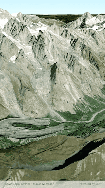
Scene views are 3D representations of real-world areas and objects. Scene views are helpful for visualizing complex datasets where 3D relationships, topography, and elevation of elements are important factors.
How to use the sample
When loaded, the sample will display a scene. Pan and zoom to explore the scene.
How it works
- Create an
ArcGISSceneobject with thearcGISImageryStandardbasemap style. - Create an
ArcGISTiledElevationSourceand add it to the scene's base surface. - Create a
ArcGISSceneViewand assign the map. - Set the scene to the scene view.
Relevant API
- ArcGISScene
- ArcGISTiledElevationSource
- SceneView
Tags
3D, basemap, elevation, scene, surface
Sample Code
display_scene.dart
// Copyright 2025 Esri
//
// Licensed under the Apache License, Version 2.0 (the "License");
// you may not use this file except in compliance with the License.
// You may obtain a copy of the License at
//
// https://www.apache.org/licenses/LICENSE-2.0
//
// Unless required by applicable law or agreed to in writing, software
// distributed under the License is distributed on an "AS IS" BASIS,
// WITHOUT WARRANTIES OR CONDITIONS OF ANY KIND, either express or implied.
// See the License for the specific language governing permissions and
// limitations under the License.
//
import 'package:arcgis_maps/arcgis_maps.dart';
import 'package:arcgis_maps_sdk_flutter_samples/common/common.dart';
import 'package:flutter/material.dart';
class DisplayScene extends StatefulWidget {
const DisplayScene({super.key});
@override
State<DisplayScene> createState() => _DisplaySceneState();
}
class _DisplaySceneState extends State<DisplayScene> with SampleStateSupport {
// Create a controller for the scene view.
final _sceneViewController = ArcGISSceneView.createController();
@override
Widget build(BuildContext context) {
return Scaffold(
body: ArcGISSceneView(
controllerProvider: () => _sceneViewController,
onSceneViewReady: onSceneViewReady,
),
);
}
Future<void> onSceneViewReady() async {
// Create a scene with the imagery standard basemap style.
final scene = ArcGISScene.withBasemapStyle(
BasemapStyle.arcGISImageryStandard,
);
// Add scene (with an imagery basemap) to the scene view's scene property.
_sceneViewController.arcGISScene = scene;
// Create an ArcGIS tiled elevation.
final arcGISTiledElevationSource = ArcGISTiledElevationSource.withUri(
Uri.parse(
'https://elevation3d.arcgis.com/arcgis/rest/services/WorldElevation3D/Terrain3D/ImageServer',
),
);
// Add the ArcGIS tiled elevation source to the surface's elevated sources collection.
scene.baseSurface.elevationSources.add(arcGISTiledElevationSource);
// Create camera with an initial camera position (Mount Everest in the Alps mountains).
final camera = Camera.withLatLong(
latitude: 45.74,
longitude: 6.88,
altitude: 4500,
heading: 10,
pitch: 70,
roll: 0,
);
// Set the scene view's camera position.
await _sceneViewController.setViewpointCameraAnimated(camera: camera);
}
}