Filter 3D scene features out of a given geometry with a polygon filter.
Use case
You can directly control what users see within a specific scene view to give a more focused or cleaner user experience by using a SceneLayerPolygonFilter to selectively show or hide scene features within a given area.
How to use the sample
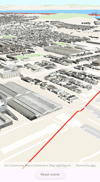
The sample initializes showing the 3D buildings OpenStreetMap layer. Tap the "Load detailed buildings" button to load an additional scene layer that contains more detailed buildings. Notice how the two scene layers overlap and clip into each other. Tap the "Filter OSM buildings" button, to set a SceneLayerPolygonFilter and filter out the OpenStreetMap buildings within the extent of the detailed buildings scene. Notice how the OSM buildings within and intersecting the extent of the detailed buildings layer are hidden. Tap the "Reset scene" button to hide the detailed buildings scene layer and clear the OSM buildings filter.
How it works
- Construct a
Basemapfor the scene using a topographicArcGISVectorTileLayerand the OpenStreetMap 3D BuildingsArcGISSceneLayeras base layers. - Create a
Surfacefor the scene and set the World Elevation 3D as an elevation source. - Add the 3D San Francisco Buildings
ArcGISSceneLayerto the scene's operational layers. - Construct a
SceneLayerPolygonFilterwith the extent of the San Francisco Buildings Scene Layer and theSceneLayerPolygonFilterSpatialRelationship.disjointenum to hide all features within the extent. - Set the
SceneLayerPolygonFilteron the OSM Buildings layer to hide all OSM buildings within the extent of the San Francisco Buildings layer.
Relevant API
- ArcGISSceneLayer
- SceneLayerPolygonFilter
- SceneLayerPolygonFilterSpatialRelationship
About the data
This sample uses the OpenStreetMap 3D Buildings which provides generic 3D outlines of buildings throughout the world. It is based on the OSM Daylight map distribution and is hosted by Esri. It uses the San Francisco 3D Buildings scene layer which provides detailed 3D models of buildings in San Francisco, California, USA.
Additional information
This sample uses SceneLayerPolygonFilterSpatialRelationship.disjoint to hide all features within the extent of the given geometry. You can alternatively use SceneLayerPolygonFilterSpatialRelationship.contains to only show features within the extent of the geometry.
You can also show or hide features in a scene layer using ArcGISSceneLayer.setFeatureVisible or setFeaturesVisible and pass in a feature or list of features and a boolean value to set their visibility.
Tags
3D, buildings, disjoint, exclude, extent, filter, hide, OSM, polygon
Sample Code
// Copyright 2025 Esri
//
// Licensed under the Apache License, Version 2.0 (the "License");
// you may not use this file except in compliance with the License.
// You may obtain a copy of the License at
//
// https://www.apache.org/licenses/LICENSE-2.0
//
// Unless required by applicable law or agreed to in writing, software
// distributed under the License is distributed on an "AS IS" BASIS,
// WITHOUT WARRANTIES OR CONDITIONS OF ANY KIND, either express or implied.
// See the License for the specific language governing permissions and
// limitations under the License.
//
import 'package:arcgis_maps/arcgis_maps.dart';
import 'package:arcgis_maps_sdk_flutter_samples/common/common.dart';
import 'package:flutter/material.dart';
class FilterFeaturesInScene extends StatefulWidget {
const FilterFeaturesInScene({super.key});
@override
State<FilterFeaturesInScene> createState() => _FilterFeaturesInSceneState();
}
class _FilterFeaturesInSceneState extends State<FilterFeaturesInScene>
with SampleStateSupport {
// Create a controller for the scene view.
final _sceneViewController = ArcGISSceneView.createController();
// A flag for when the scene view is ready.
var _ready = false;
// ArcGIS Online services.
final _osmTopographic =
'https://www.arcgis.com/home/item.html?id=1e7d1784d1ef4b79ba6764d0bd6c3150';
final _elevationSource =
'https://elevation3d.arcgis.com/arcgis/rest/services/WorldElevation3D/Terrain3D/ImageServer';
final _sanFranciscoBuildings =
'https://tiles.arcgis.com/tiles/z2tnIkrLQ2BRzr6P/arcgis/rest/services/SanFrancisco_Bldgs/SceneServer';
// San Francisco buildings scene layer for the sample.
late ArcGISSceneLayer _sfBuildingsSceneLayer;
// Open Street Map buildings scene layer for the sample.
late ArcGISSceneLayer _osmBuildingsSceneLayer;
// A Graphic to get San Francisco's information.
Graphic _sfGraphic = Graphic();
// A Graphics overlay to present the graphic for the sample.
final _sfGraphicsOverlay = GraphicsOverlay();
// A Polygon geometry that represents the San Francisco buildings scene layer full extent.
late Geometry _sceneLayerExtentPolygon;
// A filter that limits the visible features of the scene layer.
late SceneLayerPolygonFilter _sceneLayerPolygonFilter;
// A state for filtering features in a scene.
SceneFilterAction _sceneFilterAction = SceneFilterAction.load;
@override
Widget build(BuildContext context) {
return Scaffold(
body: SafeArea(
top: false,
left: false,
right: false,
child: Stack(
children: [
Column(
children: [
Expanded(
// Add a scene view to the widget tree and set a controller.
child: ArcGISSceneView(
controllerProvider: () => _sceneViewController,
onSceneViewReady: onSceneViewReady,
),
),
Center(
child: ElevatedButton(
onPressed: onSceneActionPressed,
child: Text(_sceneFilterAction.label),
),
),
],
),
// Display a progress indicator and prevent interaction until state is ready.
LoadingIndicator(visible: !_ready),
],
),
),
);
}
Future<void> onSceneViewReady() async {
final scene = _setupScene();
_sceneViewController.arcGISScene = scene;
// Create a scene layer for the San Francisco buildings.
_sfBuildingsSceneLayer = ArcGISSceneLayer.withUri(
Uri.parse(_sanFranciscoBuildings),
);
await _sfBuildingsSceneLayer.load();
// Add the graphics overlay to the scene view controller.
_sceneViewController.graphicsOverlays.add(_sfGraphicsOverlay);
_createAndFilterPolygon();
setState(() => _ready = true);
}
ArcGISScene _setupScene() {
// Create a scene.
final scene = ArcGISScene();
// Create on ArcGIS Online portal instance.
final arcGISOnlinePortal = Portal.arcGISOnline();
// Create the Open Street Map scene layer from the portal item.
_osmBuildingsSceneLayer = ArcGISSceneLayer.withItem(
PortalItem.withPortalAndItemId(
portal: arcGISOnlinePortal,
itemId: 'ca0470dbbddb4db28bad74ed39949e25',
),
);
// Add base layers to the basemap in the scene.
scene.basemap?.baseLayers.addAll([
ArcGISVectorTiledLayer.withUri(Uri.parse(_osmTopographic)),
_osmBuildingsSceneLayer,
]);
// Add surface elevation to the scene.
final worldElevationService = Uri.parse(_elevationSource);
final elevationSource = ArcGISTiledElevationSource.withUri(
worldElevationService,
);
scene.baseSurface.elevationSources.add(elevationSource);
// Create camera with an initial camera position.
final camera = Camera.withLocation(
location: ArcGISPoint(x: -122.421, y: 37.7041, z: 207),
heading: 60,
pitch: 70,
roll: 0,
);
// Set the scene's initial viewpoint.
scene.initialViewpoint = Viewpoint.withPointScaleCamera(
center: ArcGISPoint(x: 0, y: 0),
scale: 1,
camera: camera,
);
return scene;
}
// Builds a polygon from the San Francisco buildings extent,
// adds a red outline graphic, and sets up a filter for OSM buildings.
void _createAndFilterPolygon() {
// Build a polygon from the full extent of the San Francisco buildings layer.
final polygonBuilder = PolygonBuilder(
spatialReference: _sceneViewController.spatialReference,
);
final extent = _sfBuildingsSceneLayer.fullExtent!;
polygonBuilder.addPointXY(x: extent.xMin, y: extent.yMin);
polygonBuilder.addPointXY(x: extent.xMax, y: extent.yMin);
polygonBuilder.addPointXY(x: extent.xMax, y: extent.yMax);
polygonBuilder.addPointXY(x: extent.xMin, y: extent.yMax);
// Convert the polygon builder to a geometry.
_sceneLayerExtentPolygon = polygonBuilder.toGeometry();
// Create a red outline symbol with transparent fill.
final outlineSymbol = SimpleFillSymbol(
color: Colors.transparent,
outline: SimpleLineSymbol(color: Colors.red, width: 5),
);
// Create a graphic using the polygon geometry and symbol.
_sfGraphic = Graphic(
geometry: polygonBuilder.toGeometry(),
symbol: outlineSymbol,
);
// Create the SceneLayerPolygonFilter to later apply to the OSM buildings layer.
_sceneLayerPolygonFilter = SceneLayerPolygonFilter(
polygons: [polygonBuilder.toGeometry() as Polygon],
spatialRelationship: SceneLayerPolygonFilterSpatialRelationship.disjoint,
);
}
// Filter scene based on the current filter action.
void onSceneActionPressed() {
switch (_sceneFilterAction) {
case SceneFilterAction.load:
_addBuildings();
case SceneFilterAction.filter:
_filterScene();
case SceneFilterAction.reset:
_resetScene();
}
setState(() => _sceneFilterAction = _sceneFilterAction.next());
}
// Add the San Francisco buildings scene layer and its extent graphic to the scene.
void _addBuildings() {
_sceneViewController.arcGISScene?.operationalLayers.add(
_sfBuildingsSceneLayer,
);
_sfGraphicsOverlay.graphics.add(_sfGraphic);
}
// Apply a polygon filter to hide OSM buildings within the San Francisco extent.
void _filterScene() {
// If no filter is set, assign the polygon filter.
if (_osmBuildingsSceneLayer.polygonFilter == null) {
_osmBuildingsSceneLayer.polygonFilter = _sceneLayerPolygonFilter;
}
// If the filter exists but has no polygons, add the extent polygon.
else {
_sceneLayerPolygonFilter.polygons.add(
_sceneLayerExtentPolygon as Polygon,
);
}
}
// Reset the scene by removing layers, filters, and graphics.
void _resetScene() {
_sceneViewController.arcGISScene!.operationalLayers.clear();
_osmBuildingsSceneLayer.polygonFilter?.polygons.clear();
_sfGraphicsOverlay.graphics.clear();
}
}
// The different states for filtering features in a scene.
enum SceneFilterAction {
load('Load detailed buildings'),
filter('Filter OSM buildings'),
reset('Reset scene');
const SceneFilterAction(this.label);
final String label;
// The next action to apply to a scene.
SceneFilterAction next() {
switch (this) {
case SceneFilterAction.load:
return SceneFilterAction.filter;
case SceneFilterAction.filter:
return SceneFilterAction.reset;
case SceneFilterAction.reset:
return SceneFilterAction.load;
}
}
}