Group a collection of layers together and toggle their visibility as a group.
Use case
Group layers communicate to the user that layers are related and can be managed together.
In a land development project, you might group layers according to the phase of development.
How to use the sample
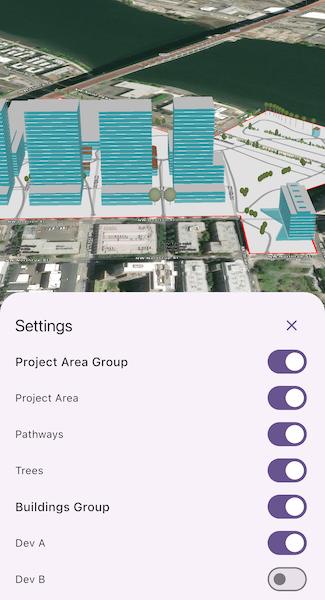
The layers in the scene will be displayed in a table of contents. Toggle the checkbox next to a layer’s name to change its visibility. Turning a group layer’s visibility off will override the visibility of its child layers.
How it works
- Create an empty
GroupLayer. - Add a child layer to the group layer’s layers collection.
- Set the group layer’s
GroupVisibilityModeto change its behavior:
GroupVisibilityMode.independentallows each sublayer to change its visibility independently.GroupVisibilityMode.exclusiveallows only one sublayer to be visible at a time.GroupVisibilityMode.inheritedtreats the group layer as if it is one merged layer.
- To toggle the visibility of the group, simply change the group layer’s visibility property.
Relevant API
- GroupLayer
Additional information
The full extent of a group layer may change when child layers are added/removed. Group layers do not have a spatial reference, but the full extent will have the spatial reference of the first child layer.
Group layers can be saved to web scenes. In web maps, group layers will be ignored.
Tags
group layer, layers
Sample Code
// Copyright 2024 Esri//// Licensed under the Apache License, Version 2.0 (the "License");// you may not use this file except in compliance with the License.// You may obtain a copy of the License at////   https://www.apache.org/licenses/LICENSE-2.0//// Unless required by applicable law or agreed to in writing, software// distributed under the License is distributed on an "AS IS" BASIS,// WITHOUT WARRANTIES OR CONDITIONS OF ANY KIND, either express or implied.// See the License for the specific language governing permissions and// limitations under the License.//
import 'package:arcgis_maps/arcgis_maps.dart';import 'package:arcgis_maps_sdk_flutter_samples/common/common.dart';import 'package:flutter/material.dart';
class GroupLayersTogether extends StatefulWidget {  const GroupLayersTogether({super.key});
  @override  State<GroupLayersTogether> createState() => _GroupLayersTogetherState();}
class _GroupLayersTogetherState extends State<GroupLayersTogether>    with SampleStateSupport {  // Create a controller for the scene view.  final _sceneViewController = ArcGISSceneView.createController();  // A flag for when the scene view is ready and controls can be used.  var _ready = false;  // A flag for when the settings bottom sheet is visible.  var _settingsVisible = false;
  @override  Widget build(BuildContext context) {    return Scaffold(      body: SafeArea(        top: false,        left: false,        right: false,        child: Stack(          children: [            Column(              children: [                Expanded(                  // Add a scene view to the widget tree and set a controller.                  child: ArcGISSceneView(                    controllerProvider: () => _sceneViewController,                    onSceneViewReady: onSceneViewReady,                  ),                ),                Row(                  mainAxisAlignment: MainAxisAlignment.spaceEvenly,                  children: [                    // A button to show the Settings bottom sheet.                    ElevatedButton(                      onPressed: () => setState(() => _settingsVisible = true),                      child: const Text('Settings'),                    ),                  ],                ),              ],            ),            // Display a progress indicator and prevent interaction until state is ready.            LoadingIndicator(visible: !_ready),          ],        ),      ),      // The Settings bottom sheet.      bottomSheet: _settingsVisible ? buildSettings(context) : null,    );  }
  // The build method for the Settings bottom sheet.  Widget buildSettings(BuildContext context) {    return BottomSheetSettings(      onCloseIconPressed: () => setState(() => _settingsVisible = false),      settingsWidgets: (context) => [        Container(          constraints: BoxConstraints(            maxHeight: MediaQuery.sizeOf(context).height * 0.4,          ),          child: SingleChildScrollView(            child: Column(              crossAxisAlignment: CrossAxisAlignment.stretch,              children:                  _sceneViewController.arcGISScene?.operationalLayers                      .whereType<GroupLayer>()                      .map(                        (groupLayer) =>                            GroupLayerWidget(groupLayer: groupLayer),                      )                      .toList() ??                  [],            ),          ),        ),      ],    );  }
  Future<void> onSceneViewReady() async {    // Create a Group Layer for the Project Area Group.    final projectAreaGroupLayer = GroupLayer()..name = 'Project Area Group';    // Create a Feature Layer for the Project Area.    final projectAreaTable = ServiceFeatureTable.withUri(      Uri.parse(        'https://services.arcgis.com/P3ePLMYs2RVChkJx/arcgis/rest/services/DevelopmentProjectArea/FeatureServer/0',      ),    );    final projectAreaLayer = FeatureLayer.withFeatureTable(projectAreaTable)      ..name = 'Project Area';    // Create a Feature Layer for the Pathways.    final pathwaysTable = ServiceFeatureTable.withUri(      Uri.parse(        'https://services.arcgis.com/P3ePLMYs2RVChkJx/arcgis/rest/services/DevA_Pathways/FeatureServer/1',      ),    );    final pathwaysLayer = FeatureLayer.withFeatureTable(pathwaysTable)      ..name = 'Pathways';    // Create a Scene Layer for the Trees.    final treesLayer = ArcGISSceneLayer.withUri(      Uri.parse(        'https://tiles.arcgis.com/tiles/P3ePLMYs2RVChkJx/arcgis/rest/services/DevA_Trees/SceneServer/layers/0',      ),    )..name = 'Trees';    // Add the layers to the Group Layer.    projectAreaGroupLayer.layers.addAll([      projectAreaLayer,      pathwaysLayer,      treesLayer,    ]);
    // Create a Group Layer for the Buildings Group with "exclusive" visibility.    final buildingsGroupLayer = GroupLayer()      ..name = 'Buildings Group'      ..visibilityMode = GroupVisibilityMode.exclusive;    // Create a Scene Layer for the Dev A buildings.    final buildingsALayer = ArcGISSceneLayer.withUri(      Uri.parse(        'https://tiles.arcgis.com/tiles/P3ePLMYs2RVChkJx/arcgis/rest/services/DevA_BuildingShells/SceneServer/layers/0',      ),    )..name = 'Dev A';    // Create a Scene Layer for the Dev B buildings.    final buildingsBLayer = ArcGISSceneLayer.withUri(      Uri.parse(        'https://tiles.arcgis.com/tiles/P3ePLMYs2RVChkJx/arcgis/rest/services/DevB_BuildingShells/SceneServer/layers/0',      ),    )..name = 'Dev B';    buildingsGroupLayer.layers.addAll([buildingsALayer, buildingsBLayer]);
    // Create a scene with the ArcGIS Imagery basemap style.    final scene = ArcGISScene.withBasemapStyle(BasemapStyle.arcGISImagery);    // Add the Group Layers to the scene.    scene.operationalLayers.addAll([      projectAreaGroupLayer,      buildingsGroupLayer,    ]);    // Set the scene to the scene view.    _sceneViewController.arcGISScene = scene;
    // Load the project area layer to get its extent.    await projectAreaLayer.load();    // Set the initial viewpoint centered on the extent of the project area layer.    if (projectAreaLayer.fullExtent != null) {      _sceneViewController.setViewpointCamera(        Camera.withLookAtPoint(          lookAtPoint: projectAreaLayer.fullExtent!.center,          distance: 800,          heading: 0,          pitch: 60,          roll: 0,        ),      );    }
    // Set the ready state variable to true to enable the UI.    setState(() => _ready = true);  }}
// A widget to display a Group Layer and its individual layers with visibility toggles.class GroupLayerWidget extends StatelessWidget {  const GroupLayerWidget({required this.groupLayer, super.key});
  final GroupLayer groupLayer;
  @override  Widget build(BuildContext context) {    // Create a StreamBuilder to listen for changes to the visibility of the Group Layer.    return StreamBuilder(      initialData: groupLayer.isVisible,      stream: groupLayer.onVisibilityChanged,      builder: (context, snapshot) {        return Column(          crossAxisAlignment: CrossAxisAlignment.stretch,          children: [            Row(              children: [                // Display the name of the Group Layer.                Text(                  groupLayer.name,                  style: Theme.of(context).textTheme.titleMedium,                ),                const Spacer(),                // Create a Switch to toggle the visibility of the Group Layer.                Switch(                  value: groupLayer.isVisible,                  onChanged: (value) => groupLayer.isVisible = value,                ),              ],            ),            // Create a list of Switches to toggle the visibility of the individual layers.            ...groupLayer.layers.map((layer) {              return Row(                children: [                  Text(layer.name),                  const Spacer(),                  // Create a StreamBuilder to listen for changes to the visibility of the individual layer.                  StreamBuilder(                    initialData: layer.isVisible,                    stream: layer.onVisibilityChanged,                    builder: (context, snapshot) {                      // Create a Switch to toggle the visibility of the individual layer.                      return Switch(                        value: layer.isVisible,                        onChanged: groupLayer.isVisible                            ? (value) => layer.isVisible = value                            : null,                      );                    },                  ),                ],              );            }),          ],        );      },    );  }}