Extrude features based on their attributes.
Use case
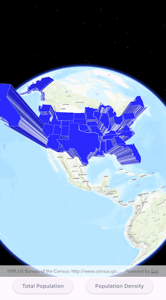
Extrusion is the process of stretching a flat, 2D shape vertically to create a 3D object in a scene. For example, you can extrude building polygons by a height value to create three-dimensional building shapes.
How to use the sample
Tap the button to switch between using population density and total population for extrusion. Higher extrusion directly corresponds to higher attribute values.
How it works
- Create a
ServiceFeatureTablefrom a URL. - Create a feature layer from the service feature table.
- Make sure to set the rendering mode to dynamic,
featureLayer.renderingMode = FeatureRenderingMode.dynamic.
- Make sure to set the rendering mode to dynamic,
- Apply a
SimpleRendererto the feature layer. - Set
ExtrusionModeof renderer,sceneProperties.extrusionMode = ExtrusionMode.absoluteHeight. - Set extrusion expression of renderer,
sceneProperties.extrusionExpression = '[POP2007]/ 10'.
Relevant API
- ExtrusionExpression
- ExtrusionMode
- FeatureLayer
- SceneProperties
- ServiceFeatureTable
- SimpleRenderer
Tags
3D, extrude, extrusion, extrusion expression, height, renderer, scene
Sample Code
show_extruded_features.dart
// Copyright 2025 Esri
//
// Licensed under the Apache License, Version 2.0 (the "License");
// you may not use this file except in compliance with the License.
// You may obtain a copy of the License at
//
// https://www.apache.org/licenses/LICENSE-2.0
//
// Unless required by applicable law or agreed to in writing, software
// distributed under the License is distributed on an "AS IS" BASIS,
// WITHOUT WARRANTIES OR CONDITIONS OF ANY KIND, either express or implied.
// See the License for the specific language governing permissions and
// limitations under the License.
//
import 'package:arcgis_maps/arcgis_maps.dart';
import 'package:arcgis_maps_sdk_flutter_samples/common/common.dart';
import 'package:flutter/material.dart';
class ShowExtrudedFeatures extends StatefulWidget {
const ShowExtrudedFeatures({super.key});
@override
State<ShowExtrudedFeatures> createState() => _ShowExtrudedFeaturesState();
}
class _ShowExtrudedFeaturesState extends State<ShowExtrudedFeatures>
with SampleStateSupport {
// Create a controller for the scene view.
final _sceneViewController = ArcGISSceneView.createController();
// A flag for when the scene view is ready and controls can be used.
var _ready = false;
// An enum representing types of population statistics.
var _filterType = FilterType.totalPopulation;
@override
Widget build(BuildContext context) {
return Scaffold(
body: SafeArea(
top: false,
left: false,
right: false,
child: Stack(
children: [
Column(
children: [
Expanded(
// Add a scene view to the widget tree and set a controller.
child: ArcGISSceneView(
controllerProvider: () => _sceneViewController,
onSceneViewReady: onSceneViewReady,
),
),
Row(
mainAxisAlignment: MainAxisAlignment.spaceEvenly,
// Create a set of evenly spaced buttons for each FilterType value, and when a button is pressed,
// it triggers the changeExtrusionExpression function with the selected filter.
children: FilterType.values
.map(
(filterType) => ElevatedButton(
onPressed: () =>
changeExtrusionExpression(filterType),
child: Text(filterType.name),
),
)
.toList(),
),
],
),
// Display a progress indicator and prevent interaction until state is ready.
LoadingIndicator(visible: !_ready),
],
),
),
);
}
void onSceneViewReady() {
// Define the Uri for the service feature table (US state polygons).
final serviceFeatureTableUri = Uri.parse(
'https://sampleserver6.arcgisonline.com/arcgis/rest/services/Census/MapServer/3',
);
// Create a service feature table from the Uri.
final featureTable = ServiceFeatureTable.withUri(serviceFeatureTableUri);
// Create a feature layer from the service feature table.
final featureLayer = FeatureLayer.withFeatureTable(featureTable);
// Set the rendering mode of the feature layer to be dynamic (needed for extrusion to work).
featureLayer.renderingMode = FeatureRenderingMode.dynamic;
// Create a simple line symbol for the feature layer.
final simpleLineSymbol = SimpleLineSymbol(
color: Colors.white.withAlpha(100),
);
// Create a simple fill symbol for the feature layer.
final simpleFillSymbol = SimpleFillSymbol(
color: const Color(0xFF2727f1),
outline: simpleLineSymbol,
);
// Create a simple renderer for the feature layer.
final simpleRenderer = SimpleRenderer(symbol: simpleFillSymbol);
// Get the scene properties from the simple renderer.
final sceneProperties = simpleRenderer.sceneProperties;
// Set the renderer scene properties.
sceneProperties.extrusionMode = ExtrusionMode.absoluteHeight;
sceneProperties.extrusionExpression = _filterType.extrusionExpression;
// Set the feature layer's renderer to the defined simple renderer.
featureLayer.renderer = simpleRenderer;
// Create a scene with a topographic basemap style.
final scene = ArcGISScene.withBasemapStyle(BasemapStyle.arcGISTopographic);
_sceneViewController.arcGISScene = scene;
// Add the feature layer to the scene's operational layer collection.
scene.operationalLayers.add(featureLayer);
// Set the scene view's viewpoint specified by the camera position.
final point = ArcGISPoint(
x: -10974490,
y: 4814376,
z: 0,
spatialReference: SpatialReference.webMercator,
);
// Create an orbit location camera controller.
final cameraController =
OrbitLocationCameraController.withTargetPositionAndCameraDistance(
targetLocation: point,
distance: 20000000,
);
// Set the scene view's camera controller to the orbit location camera controller.
_sceneViewController.cameraController = cameraController;
// Set the ready state variable to true to enable the sample UI.
setState(() => _ready = true);
}
void changeExtrusionExpression(FilterType filterType) {
setState(() => _filterType = filterType);
// Get the first layer from the scene view's operational layers.
final featureLayer =
_sceneViewController.arcGISScene!.operationalLayers[0] as FeatureLayer;
// Update the renderer's scene properties to the selected extrusion expression.
featureLayer.renderer!.sceneProperties.extrusionExpression =
_filterType.extrusionExpression;
}
}
// An enum representing different types of population statistics filters.
enum FilterType {
totalPopulation(
name: 'Total Population',
extrusionExpression: '[POP2007] / 10',
),
populationDensity(
name: 'Population Density',
extrusionExpression: '[POP07_SQMI] * 5000 + 100000',
);
const FilterType({required this.name, required this.extrusionExpression});
final String name;
final String extrusionExpression;
}