Analyze the viewshed for an object (GeoElement) in a scene.
Use case
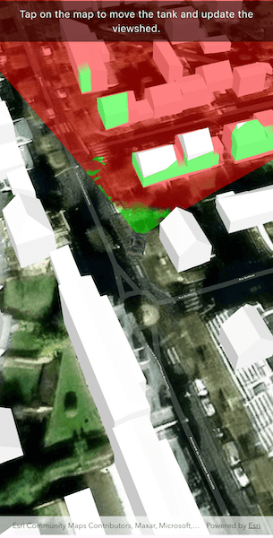
A viewshed analysis is a type of visual analysis you can perform on a scene. The viewshed aims to answer the question 'What can I see from a given location?'. The output is an overlay with two different colors - one representing the visible areas (green) and the other representing the obstructed areas (red).
How to use the sample
Tap to set a destination for the vehicle (a GeoElement). The vehicle will 'drive' towards the tapped location. The viewshed analysis will update as the vehicle moves.
How it works
- Create and show the
ArcGISScene, with an elevation source and a buildings layer. - Add a model (the
GeoElement) to represent the observer (in this case, a tank).- Use a
SimpleRendererwhich has a heading expression set in theGraphicsOverlay. This way you can relate the viewshed's heading to theGeoElementobject's heading.
- Use a
- Create a
GeoElementViewshedwith configuration for the viewshed analysis. - Add the viewshed to an
AnalysisOverlayand add the overlay to the scene. - Configure the SceneView
CameraControllerto orbit the vehicle.
Relevant API
- AnalysisOverlay
- GeodeticDistanceResult
- GeoElementViewshed
- GeometryEngine.distanceGeodetic
- GeometryEngine.moveGeodetic
- ModelSceneSymbol
- OrbitGeoElementCameraController
Offline data
About the data
This sample shows a Buildings in Brest, France Scene from ArcGIS Online. The sample uses a Tank model scene symbol hosted as an item on ArcGIS Online.
Tags
3D, analysis, buildings, model, scene, viewshed, visibility analysis
Sample Code
// Copyright 2025 Esri
//
// Licensed under the Apache License, Version 2.0 (the "License");
// you may not use this file except in compliance with the License.
// You may obtain a copy of the License at
//
// https://www.apache.org/licenses/LICENSE-2.0
//
// Unless required by applicable law or agreed to in writing, software
// distributed under the License is distributed on an "AS IS" BASIS,
// WITHOUT WARRANTIES OR CONDITIONS OF ANY KIND, either express or implied.
// See the License for the specific language governing permissions and
// limitations under the License.
//
import 'dart:async';
import 'dart:io';
import 'package:arcgis_maps/arcgis_maps.dart';
import 'package:arcgis_maps_sdk_flutter_samples/common/common.dart';
import 'package:flutter/material.dart';
import 'package:path_provider/path_provider.dart';
class ShowViewshedFromGeoelementInScene extends StatefulWidget {
const ShowViewshedFromGeoelementInScene({super.key});
@override
State<ShowViewshedFromGeoelementInScene> createState() =>
_ShowViewshedFromGeoelementInSceneState();
}
class _ShowViewshedFromGeoelementInSceneState
extends State<ShowViewshedFromGeoelementInScene>
with SampleStateSupport {
// Create a controller for the scene view.
final _sceneViewController = ArcGISSceneView.createController();
// The graphic for the tank.
Graphic? _tankGraphic;
// Timer for animation.
Timer? _animationTimer;
// Waypoint for tank graphic.
ArcGISPoint? _waypoint;
// A flag for when the map view is ready and controls can be used.
var _ready = false;
@override
Widget build(BuildContext context) {
return Scaffold(
body: SafeArea(
top: false,
left: false,
right: false,
child: Stack(
children: [
// Add a scene view to the widget tree and set a controller.
ArcGISSceneView(
controllerProvider: () => _sceneViewController,
onSceneViewReady: onSceneViewReady,
onTap: onTap,
),
// Display a progress indicator and prevent interaction until state is ready.
LoadingIndicator(visible: !_ready),
// Banner at the top.
SafeArea(
child: IgnorePointer(
child: Container(
width: double.infinity,
padding: const EdgeInsets.all(10),
color: Colors.black.withValues(alpha: 0.5),
child: const Text(
'Tap on the map to move the tank and update the viewshed.',
textAlign: TextAlign.center,
style: TextStyle(color: Colors.white, fontSize: 16),
),
),
),
),
],
),
),
);
}
// Called when the scene view is ready.
Future<void> onSceneViewReady() async {
// Create and configure the scene with elevation.
final scene = _createScene();
// Assign the scene to the scene view controller.
_sceneViewController.arcGISScene = scene;
// Load the tank graphic from the local data.
_tankGraphic = await _loadTankGraphic();
// Add the tank graphic to the scene.
_addTankToScene(_tankGraphic!);
// Set up the orbit camera controller to follow the tank.
_setupCameraController(_tankGraphic!);
// Add the viewshed to the scene.
_addViewshedToScene(_tankGraphic!);
setState(() => _ready = true);
}
// Creates a scene with an imagery basemap and adds elevation data.
ArcGISScene _createScene() {
final scene = ArcGISScene.withBasemapStyle(BasemapStyle.arcGISImagery);
// Add world elevation source to the scene's surface.
final elevationSource = ArcGISTiledElevationSource.withUri(
Uri.parse(
'https://elevation3d.arcgis.com/arcgis/rest/services/WorldElevation3D/Terrain3D/ImageServer',
),
);
scene.baseSurface.elevationSources.add(elevationSource);
// Create the building layer and add it to the scene.
final buildingsLayer = ArcGISSceneLayer.withUri(
Uri.parse(
'https://tiles.arcgis.com/tiles/P3ePLMYs2RVChkJx/arcgis/rest/services/Buildings_Brest/SceneServer/layers/0',
),
);
scene.operationalLayers.add(buildingsLayer);
return scene;
}
// Convert the tapped location into a waypoint within the scene and initiate the tank's animation towards the waypoint.
Future<void> onTap(Offset localPosition) async {
// Convert localPosition to scenePoint.
final scenePoint = await _sceneViewController.screenToLocation(
screen: localPosition,
);
setState(() => _waypoint = scenePoint);
_startTankAnimation();
}
// Animate the tank toward the waypoint.
void _startTankAnimation() {
// Cancel any existing timer.
_animationTimer?.cancel();
_animationTimer = Timer.periodic(const Duration(milliseconds: 100), (
timer,
) async {
if (_tankGraphic == null || _waypoint == null) return;
final tempPos = _tankGraphic!.geometry! as ArcGISPoint;
final currentPos = ArcGISPoint(
x: tempPos.x,
y: tempPos.y,
spatialReference: SpatialReference.wgs84,
);
final target = ArcGISPoint(
x: _waypoint!.x,
y: _waypoint!.y,
spatialReference: SpatialReference.wgs84,
);
// Use geodetic distance to get distance and azimuth.
final result = GeometryEngine.distanceGeodetic(
point1: currentPos,
point2: target,
distanceUnit: LinearUnit(unitId: LinearUnitId.meters),
azimuthUnit: AngularUnit(unitId: AngularUnitId.degrees),
curveType: GeodeticCurveType.geodesic,
);
final distance = result.distance;
final azimuth = result.azimuth1;
// Stop if close enough.
if (distance <= 5) {
_waypoint = null;
timer.cancel();
return;
}
// Move a small step toward the waypoint.
const step = 1.0; // meters
final movedPoints = GeometryEngine.moveGeodetic(
pointCollection: [currentPos],
distance: step,
azimuth: azimuth,
distanceUnit: LinearUnit(unitId: LinearUnitId.meters),
azimuthUnit: AngularUnit(unitId: AngularUnitId.degrees),
curveType: GeodeticCurveType.geodesic,
);
if (movedPoints.isEmpty) return;
final newPoint = movedPoints.first;
_tankGraphic!.geometry = newPoint;
// Update heading.
final currentHeading =
(_tankGraphic!.attributes['HEADING'] as num?)?.toDouble() ?? 0.0;
final headingDiff = shortestAngle(currentHeading, azimuth);
final newHeading = currentHeading + headingDiff / 10;
_tankGraphic!.attributes['HEADING'] = newHeading;
});
}
// Calculate shortest angle to rotate.
double shortestAngle(double from, double to) {
final difference = (to - from + 540) % 360 - 180;
return difference;
}
// Loads the 3D tank model from local sample data and returns it as a Graphic.
Future<Graphic> _loadTankGraphic() async {
const downloadFileName = 'bradley_low_3ds';
final appDir = await getApplicationDocumentsDirectory();
final zipFile = File('${appDir.absolute.path}/$downloadFileName.zip');
if (!zipFile.existsSync()) {
await downloadSampleDataWithProgress(
itemIds: ['07d62a792ab6496d9b772a24efea45d0'],
destinationFiles: [zipFile],
);
}
final tankModelPath =
'${appDir.absolute.path}/$downloadFileName/bradle.3ds';
// Define the tank symbol.
final tankSymbol =
ModelSceneSymbol.withUri(uri: Uri.parse(tankModelPath), scale: 10)
..heading = 90
..anchorPosition = SceneSymbolAnchorPosition.bottom;
// Return the graphic that combines geometry and symbol.
return Graphic(
geometry: ArcGISPoint(x: -4.506390, y: 48.385624),
attributes: {'HEADING': 0.0},
symbol: tankSymbol,
);
}
// Adds the tank graphic to a graphics overlay and sets the initial viewpoint.
void _addTankToScene(Graphic tankGraphic) {
final graphicsOverlay = GraphicsOverlay()
..graphics.add(tankGraphic)
..sceneProperties = LayerSceneProperties(
surfacePlacement: SurfacePlacement.relative,
);
// Configure the heading expression for the tank; this will allow the
// viewshed to update automatically based on the tank's position.
final renderer = SimpleRenderer()
..sceneProperties.headingExpression = '[HEADING]'
..sceneProperties.pitchExpression = '[PITCH]'
..sceneProperties.rollExpression = '[ROLL]';
graphicsOverlay.renderer = renderer;
_sceneViewController.graphicsOverlays.add(graphicsOverlay);
}
// Add viewshed to the scene.
void _addViewshedToScene(Graphic tankGraphic) {
// Create a GeoElementViewshed attached to the scene.
final geoElementViewshed =
GeoElementViewshed(
geoElement: tankGraphic,
horizontalAngle: 90,
verticalAngle: 40,
headingOffset: 0,
pitchOffset: 0,
minDistance: 0.1,
maxDistance: 250,
)
// Offset the observer location to the front of the tank.
..offsetZ = 0.5
..offsetY = 4;
// Create an Analysis Overlay and add the viewshed to it.
final analysisOverlay = AnalysisOverlay()..analyses.add(geoElementViewshed);
// Add the analysis overlay to the scene view.
_sceneViewController.analysisOverlays.add(analysisOverlay);
}
// Configures the orbit camera controller for the tank graphic.
void _setupCameraController(Graphic tankGraphic) {
final cameraController = OrbitGeoElementCameraController(
targetGeoElement: tankGraphic,
distance: 200,
);
_sceneViewController.cameraController = cameraController;
}
}