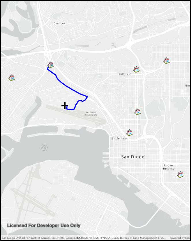
Find a route to the closest facility from a location.
Use case
Quickly and accurately determining the most efficient route between a location and a facility is a frequently encountered task. For example, a paramedic may need to know which hospital in the vicinity offers the possibility of getting an ambulance patient critical medical care in the shortest amount of time. Solving for the closest hospital to the ambulance's location using an impedance of "travel time" would provide this information.
How to use the sample
Tap near any of the hospitals and a route will be displayed from that clicked location to the nearest hospital.
How it works
- Create a
ClosestFacilityTaskusing a Url from an online network analysis service. - Get
ClosestFacilityParametersfrom task,task.CreateDefaultParametersAsync() - Add facilities to parameters,
closestFacilityParameters.Facilities.AddAll(facilities). - Add the incident to parameters,
closestFacilityParametersIncidents. - Get
ClosestFacilityResultfrom solving task with parameters,task.SolveClosestFacilityAsync(facilityParameters) - Get index list of closet facilities to incident,
facilityResult.RankedFacilities[0] - Get index of closest facility,
rankedFacilitiesList[0] - Find closest facility route,
facilityResult.Route(closestFacilityIndex, IncidentIndex) - Display route to
MapView:- Create
Graphicfrom route geometry,new Graphic(route.RouteGeometry) - Add graphic to
GraphicsOverlaywhich is attached to the mapview
- Create
Relevant API
- ClosestFacilityParameters
- ClosestFacilityResult
- ClosestFacilityRoute
- ClosestFacilityTask
- Facility
- Graphic
- GraphicsOverlay
- Incident
- MapView
Tags
incident, network analysis, route, search
Sample Code
ClosestFacility.cs
// Copyright 2021 Esri.
//
// Licensed under the Apache License, Version 2.0 (the "License"); you may not use this file except in compliance with the License.
// You may obtain a copy of the License at: http://www.apache.org/licenses/LICENSE-2.0
//
// Unless required by applicable law or agreed to in writing, software distributed under the License is distributed on an
// "AS IS" BASIS, WITHOUT WARRANTIES OR CONDITIONS OF ANY KIND, either express or implied. See the License for the specific
// language governing permissions and limitations under the License.
using Esri.ArcGISRuntime.Geometry;
using Esri.ArcGISRuntime.Mapping;
using Esri.ArcGISRuntime.Symbology;
using Esri.ArcGISRuntime.Tasks.NetworkAnalysis;
using Esri.ArcGISRuntime.UI;
using Esri.ArcGISRuntime.UI.Controls;
using Foundation;
using System;
using System.Collections.Generic;
using System.Drawing;
using System.Linq;
using System.Threading.Tasks;
using UIKit;
namespace ArcGISRuntime.Samples.ClosestFacility
{
[Register("ClosestFacility")]
[ArcGISRuntime.Samples.Shared.Attributes.Sample(
name: "Find closest facility to an incident (interactive)",
category: "Network analysis",
description: "Find a route to the closest facility from a location.",
instructions: "Tap near any of the hospitals and a route will be displayed from that clicked location to the nearest hospital.",
tags: new[] { "incident", "network analysis", "route", "search" })]
public class ClosestFacility : UIViewController
{
// Hold references to UI controls.
private MapView _myMapView;
// Holds locations of hospitals around San Diego.
private List<Facility> _facilities;
// Graphics overlays for facilities and incidents.
private GraphicsOverlay _facilityGraphicsOverlay;
// Symbol for facilities.
private PictureMarkerSymbol _facilitySymbol;
// Overlay for the incident.
private GraphicsOverlay _incidentGraphicsOverlay;
// Black cross where user clicked.
private MapPoint _incidentPoint;
// Symbol for the incident.
private SimpleMarkerSymbol _incidentSymbol;
// Used to display route between incident and facility to mapview.
private SimpleLineSymbol _routeSymbol;
// Solves task to find closest route between an incident and a facility.
private ClosestFacilityTask _task;
public ClosestFacility()
{
Title = "Closest facility";
}
private async void Initialize()
{
// Construct the map and set the MapView.Map property.
Map map = new Map(BasemapStyle.ArcGISLightGray);
_myMapView.Map = map;
try
{
// Create a ClosestFacilityTask using the San Diego Uri.
_task = await ClosestFacilityTask.CreateAsync(new Uri("https://sampleserver6.arcgisonline.com/arcgis/rest/services/NetworkAnalysis/SanDiego/NAServer/ClosestFacility"));
// List of facilities to be placed around San Diego area.
_facilities = new List<Facility>
{
new Facility(new MapPoint(-1.3042129900625112E7, 3860127.9479775648, SpatialReferences.WebMercator)),
new Facility(new MapPoint(-1.3042193400557665E7, 3862448.873041752, SpatialReferences.WebMercator)),
new Facility(new MapPoint(-1.3046882875518233E7, 3862704.9896770366, SpatialReferences.WebMercator)),
new Facility(new MapPoint(-1.3040539754780494E7, 3862924.5938606677, SpatialReferences.WebMercator)),
new Facility(new MapPoint(-1.3042571225655518E7, 3858981.773018156, SpatialReferences.WebMercator)),
new Facility(new MapPoint(-1.3039784633928463E7, 3856692.5980474586, SpatialReferences.WebMercator)),
new Facility(new MapPoint(-1.3049023883956768E7, 3861993.789732541, SpatialReferences.WebMercator))
};
// Center the map on the San Diego facilities.
Envelope fullExtent = GeometryEngine.CombineExtents(_facilities.Select(facility => facility.Geometry));
await _myMapView.SetViewpointGeometryAsync(fullExtent, 50);
// Create a symbol for displaying facilities.
_facilitySymbol = new PictureMarkerSymbol(new Uri("https://static.arcgis.com/images/Symbols/SafetyHealth/Hospital.png"))
{
Height = 30,
Width = 30
};
// Incident symbol.
_incidentSymbol = new SimpleMarkerSymbol(SimpleMarkerSymbolStyle.Cross, Color.FromArgb(255, 0, 0, 0), 30);
// Route to hospital symbol.
_routeSymbol = new SimpleLineSymbol(SimpleLineSymbolStyle.Solid, Color.FromArgb(255, 0, 0, 255), 5.0f);
// Create Graphics Overlays for incidents and facilities.
_incidentGraphicsOverlay = new GraphicsOverlay();
_facilityGraphicsOverlay = new GraphicsOverlay();
// Create a graphic and add to graphics overlay for each facility.
foreach (Facility facility in _facilities)
{
_facilityGraphicsOverlay.Graphics.Add(new Graphic(facility.Geometry, _facilitySymbol));
}
// Add each graphics overlay to MyMapView.
_myMapView.GraphicsOverlays.Add(_incidentGraphicsOverlay);
_myMapView.GraphicsOverlays.Add(_facilityGraphicsOverlay);
}
catch (Exception e)
{
new UIAlertView("Error", e.ToString(), (IUIAlertViewDelegate)null, "OK", null).Show();
}
}
private async void MyMapView_GeoViewTapped(object sender, GeoViewInputEventArgs e)
{
try
{
_myMapView.GeoViewTapped -= MyMapView_GeoViewTapped;
// Clear any prior incident and routes from the graphics.
_incidentGraphicsOverlay.Graphics.Clear();
// Get the tapped point.
_incidentPoint = e.Location;
// Populate the facility parameters than solve using the task.
await PopulateParametersAndSolveRouteAsync();
}
catch (Exception ex)
{
new UIAlertView("Error", ex.Message, (IUIAlertViewDelegate)null, "OK", null).Show();
}
finally
{
_myMapView.GeoViewTapped += MyMapView_GeoViewTapped;
}
}
private async Task PopulateParametersAndSolveRouteAsync()
{
try
{
// Set facilities and incident in parameters.
ClosestFacilityParameters closestFacilityParameters = await _task.CreateDefaultParametersAsync();
closestFacilityParameters.SetFacilities(_facilities);
closestFacilityParameters.SetIncidents(new List<Incident> { new Incident(_incidentPoint) });
// Use the task to solve for the closest facility.
ClosestFacilityResult result = await _task.SolveClosestFacilityAsync(closestFacilityParameters);
// Get the index of the closest facility to incident. (0) is the index of the incident, [0] is the index of the closest facility.
int closestFacility = result.GetRankedFacilityIndexes(0)[0];
// Get route from closest facility to the incident and display to mapview.
ClosestFacilityRoute route = result.GetRoute(closestFacility, 0);
// Add graphics for the incident and route.
_incidentGraphicsOverlay.Graphics.Add(new Graphic(_incidentPoint, _incidentSymbol));
_incidentGraphicsOverlay.Graphics.Add(new Graphic(route.RouteGeometry, _routeSymbol));
}
catch (Esri.ArcGISRuntime.Http.ArcGISWebException exception)
{
if (exception.Message.Equals("Unable to complete operation."))
{
CreateErrorDialog("Incident not within San Diego area!");
}
else
{
CreateErrorDialog("An ArcGIS web exception occurred. \n" + exception.Message);
}
}
}
private void CreateErrorDialog(string message)
{
// Create Alert.
UIAlertController okAlertController = UIAlertController.Create("Error", message, UIAlertControllerStyle.Alert);
// Add Action.
okAlertController.AddAction(UIAlertAction.Create("OK", UIAlertActionStyle.Default, null));
// Present Alert.
PresentViewController(okAlertController, true, null);
}
public override void ViewDidLoad()
{
base.ViewDidLoad();
Initialize();
}
public override void LoadView()
{
// Create the views.
View = new UIView() { BackgroundColor = ApplicationTheme.BackgroundColor };
_myMapView = new MapView();
_myMapView.TranslatesAutoresizingMaskIntoConstraints = false;
UILabel helpLabel = new UILabel
{
Text = "Tap to show the route to the nearest facility.",
AdjustsFontSizeToFitWidth = true,
TextAlignment = UITextAlignment.Center,
BackgroundColor = UIColor.FromWhiteAlpha(0, .6f),
TextColor = UIColor.White,
Lines = 1,
TranslatesAutoresizingMaskIntoConstraints = false
};
// Add the views.
View.AddSubviews(_myMapView, helpLabel);
// Lay out the views.
NSLayoutConstraint.ActivateConstraints(new[]
{
_myMapView.TopAnchor.ConstraintEqualTo(View.SafeAreaLayoutGuide.TopAnchor),
_myMapView.BottomAnchor.ConstraintEqualTo(View.BottomAnchor),
_myMapView.LeadingAnchor.ConstraintEqualTo(View.LeadingAnchor),
_myMapView.TrailingAnchor.ConstraintEqualTo(View.TrailingAnchor),
helpLabel.TopAnchor.ConstraintEqualTo(View.SafeAreaLayoutGuide.TopAnchor),
helpLabel.LeadingAnchor.ConstraintEqualTo(View.LeadingAnchor),
helpLabel.TrailingAnchor.ConstraintEqualTo(View.TrailingAnchor),
helpLabel.HeightAnchor.ConstraintEqualTo(40)
});
}
public override void ViewWillAppear(bool animated)
{
base.ViewWillAppear(animated);
// Subscribe to events.
_myMapView.GeoViewTapped += MyMapView_GeoViewTapped;
}
public override void ViewDidDisappear(bool animated)
{
base.ViewDidDisappear(animated);
// Unsubscribe from events, per best practice.
_myMapView.GeoViewTapped -= MyMapView_GeoViewTapped;
}
}
}