Determine spatial relationships between two geometries.
Use case
In case of a natural disaster, emergency services can represent the affected areas using polygons. By determining the spatial relationships between these and any other existing features such as populated areas, infrastructure, or natural resources, it is possible to quickly determine which of the existing features might be affected or is in further danger, helping to assess risk and define further action.
How to use the sample
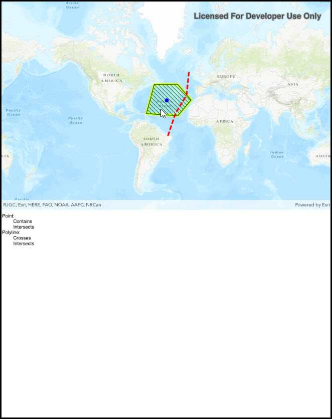
Select one of the three graphics. The tree view will list the relationships the selected graphic has to the other graphic geometries.
How it works
- Get the geometry from two different graphics. In this example the geometry of the selected graphic is compared to the geometry of each unselected graphic.
- Use the methods in
GeometryEngineto check the relationship between the geometries, e.g.contains,disjoint,intersects, etc. If the method returnstrue, the relationship exists.
Relevant API
- Geometry
- GeometryEngine
- GeometryEngine.Contains
- GeometryEngine.Crosses
- GeometryEngine.Disjoint
- GeometryEngine.Intersects
- GeometryEngine.Overlaps
- GeometryEngine.Touches
- GeometryEngine.Within
- GeometryType
- Graphic
- Point
- Polygon
- Polyline
Tags
geometries, relationship, spatial analysis
Sample Code
SpatialRelationships.cs
// Copyright 2018 Esri.
//
// Licensed under the Apache License, Version 2.0 (the "License"); you may not use this file except in compliance with the License.
// You may obtain a copy of the License at: http://www.apache.org/licenses/LICENSE-2.0
//
// Unless required by applicable law or agreed to in writing, software distributed under the License is distributed on an
// "AS IS" BASIS, WITHOUT WARRANTIES OR CONDITIONS OF ANY KIND, either express or implied. See the License for the specific
// language governing permissions and limitations under the License.
using Esri.ArcGISRuntime.Data;
using Esri.ArcGISRuntime.Geometry;
using Esri.ArcGISRuntime.Mapping;
using Esri.ArcGISRuntime.Symbology;
using Esri.ArcGISRuntime.UI;
using Esri.ArcGISRuntime.UI.Controls;
using Foundation;
using System;
using System.Collections.Generic;
using System.Drawing;
using System.Linq;
using UIKit;
namespace ArcGISRuntime.Samples.ListTransformations
{
[Register("SpatialRelationships")]
[ArcGISRuntime.Samples.Shared.Attributes.Sample(
name: "Spatial relationships",
category: "Geometry",
description: "Determine spatial relationships between two geometries.",
instructions: "Select one of the three graphics. The tree view will list the relationships the selected graphic has to the other graphic geometries.",
tags: new[] { "geometries", "relationship", "spatial analysis" })]
public class SpatialRelationships : UIViewController
{
// Hold references to UI controls.
private MapView _myMapView;
private UITextView _resultTextView;
private UIStackView _stackView;
// References to the graphics and graphics overlay.
private GraphicsOverlay _graphicsOverlay;
private Graphic _polygonGraphic;
private Graphic _polylineGraphic;
private Graphic _pointGraphic;
public SpatialRelationships()
{
Title = "Spatial relationships";
}
private async void Initialize()
{
// Configure the basemap.
_myMapView.Map = new Map(BasemapStyle.ArcGISTopographic);
// Create the graphics overlay.
_graphicsOverlay = new GraphicsOverlay();
// Add the overlay to the MapView.
_myMapView.GraphicsOverlays.Add(_graphicsOverlay);
// Update the selection color.
_myMapView.SelectionProperties.Color = Color.Yellow;
// Create the point collection that defines the polygon.
PointCollection polygonPoints = new PointCollection(SpatialReferences.WebMercator)
{
new MapPoint(-5991501.677830, 5599295.131468),
new MapPoint(-6928550.398185, 2087936.739807),
new MapPoint(-3149463.800709, 1840803.011362),
new MapPoint(-1563689.043184, 3714900.452072),
new MapPoint(-3180355.516764, 5619889.608838)
};
// Create the polygon.
Polygon polygonGeometry = new Polygon(polygonPoints);
// Define the symbology of the polygon.
SimpleLineSymbol polygonOutlineSymbol = new SimpleLineSymbol(SimpleLineSymbolStyle.Solid, System.Drawing.Color.Green, 2);
SimpleFillSymbol polygonFillSymbol = new SimpleFillSymbol(SimpleFillSymbolStyle.ForwardDiagonal, System.Drawing.Color.Green, polygonOutlineSymbol);
// Create the polygon graphic and add it to the graphics overlay.
_polygonGraphic = new Graphic(polygonGeometry, polygonFillSymbol);
_graphicsOverlay.Graphics.Add(_polygonGraphic);
// Create the point collection that defines the polyline.
PointCollection polylinePoints = new PointCollection(SpatialReferences.WebMercator)
{
new MapPoint(-4354240.726880, -609939.795721),
new MapPoint(-3427489.245210, 2139422.933233),
new MapPoint(-2109442.693501, 4301843.057130),
new MapPoint(-1810822.771630, 7205664.366363)
};
// Create the polyline.
Polyline polylineGeometry = new Polyline(polylinePoints);
// Create the polyline graphic and add it to the graphics overlay.
_polylineGraphic = new Graphic(polylineGeometry, new SimpleLineSymbol(SimpleLineSymbolStyle.Dash, System.Drawing.Color.Red, 4));
_graphicsOverlay.Graphics.Add(_polylineGraphic);
// Create the point geometry that defines the point graphic.
MapPoint pointGeometry = new MapPoint(-4487263.495911, 3699176.480377, SpatialReferences.WebMercator);
// Define the symbology for the point.
SimpleMarkerSymbol locationMarker = new SimpleMarkerSymbol(SimpleMarkerSymbolStyle.Circle, System.Drawing.Color.Blue, 10);
// Create the point graphic and add it to the graphics overlay.
_pointGraphic = new Graphic(pointGeometry, locationMarker);
_graphicsOverlay.Graphics.Add(_pointGraphic);
try
{
// Set the viewpoint to center on the point.
await _myMapView.SetViewpointAsync(new Viewpoint(pointGeometry, 200000000));
}
catch (Exception e)
{
new UIAlertView("Error", e.ToString(), (IUIAlertViewDelegate)null, "OK", null).Show();
}
}
private async void MyMapView_GeoViewTapped(object sender, GeoViewInputEventArgs e)
{
// Identify the tapped graphics.
IdentifyGraphicsOverlayResult result = null;
try
{
result = await _myMapView.IdentifyGraphicsOverlayAsync(_graphicsOverlay, e.Position, 5, false);
}
catch (Exception ex)
{
new UIAlertView("Error", ex.ToString(), (IUIAlertViewDelegate)null, "OK", null).Show();
}
// Return if there are no results.
if (result == null || result.Graphics.Count < 1)
{
return;
}
// Get the smallest identified graphic.
Graphic identifiedGraphic = result.Graphics.OrderBy(graphic => GeometryEngine.Area(graphic.Geometry)).First();
// Clear any existing selection, then select the tapped graphic.
_graphicsOverlay.ClearSelection();
identifiedGraphic.IsSelected = true;
// Get the selected graphic's geometry.
Geometry selectedGeometry = identifiedGraphic.Geometry;
// Perform the calculation and show the results.
_resultTextView.Text = GetOutputText(selectedGeometry);
}
private string GetOutputText(Geometry selectedGeometry)
{
string output = "";
// Get the relationships.
List<SpatialRelationship> polygonRelationships = GetSpatialRelationships(selectedGeometry, _polygonGraphic.Geometry);
List<SpatialRelationship> polylineRelationships = GetSpatialRelationships(selectedGeometry, _polylineGraphic.Geometry);
List<SpatialRelationship> pointRelationships = GetSpatialRelationships(selectedGeometry, _pointGraphic.Geometry);
// Add the point relationships to the output.
if (selectedGeometry.GeometryType != GeometryType.Point)
{
output += "Point:\n";
foreach (SpatialRelationship relationship in pointRelationships)
{
output += $"\t{relationship}\n";
}
}
// Add the polygon relationships to the output.
if (selectedGeometry.GeometryType != GeometryType.Polygon)
{
output += "Polygon:\n";
foreach (SpatialRelationship relationship in polygonRelationships)
{
output += $"\t{relationship}\n";
}
}
// Add the polyline relationships to the output.
if (selectedGeometry.GeometryType != GeometryType.Polyline)
{
output += "Polyline:\n";
foreach (SpatialRelationship relationship in polylineRelationships)
{
output += $"\t{relationship}\n";
}
}
return output;
}
/// <summary>
/// Returns a list of spatial relationships between two geometries.
/// </summary>
/// <param name="a">The 'a' in "a contains b".</param>
/// <param name="b">The 'b' in "a contains b".</param>
/// <returns>A list of spatial relationships that are true for a and b.</returns>
private static List<SpatialRelationship> GetSpatialRelationships(Geometry a, Geometry b)
{
List<SpatialRelationship> relationships = new List<SpatialRelationship>();
if (GeometryEngine.Crosses(a, b))
{
relationships.Add(SpatialRelationship.Crosses);
}
if (GeometryEngine.Contains(a, b))
{
relationships.Add(SpatialRelationship.Contains);
}
if (GeometryEngine.Disjoint(a, b))
{
relationships.Add(SpatialRelationship.Disjoint);
}
if (GeometryEngine.Intersects(a, b))
{
relationships.Add(SpatialRelationship.Intersects);
}
if (GeometryEngine.Overlaps(a, b))
{
relationships.Add(SpatialRelationship.Overlaps);
}
if (GeometryEngine.Touches(a, b))
{
relationships.Add(SpatialRelationship.Touches);
}
if (GeometryEngine.Within(a, b))
{
relationships.Add(SpatialRelationship.Within);
}
return relationships;
}
public override void ViewDidLoad()
{
base.ViewDidLoad();
Initialize();
}
public override void LoadView()
{
// Create the views.
View = new UIView() { BackgroundColor = ApplicationTheme.BackgroundColor };
_myMapView = new MapView();
_myMapView.TranslatesAutoresizingMaskIntoConstraints = false;
_resultTextView = new UITextView
{
TextColor = ApplicationTheme.ForegroundColor,
Text = "Tap a shape to see its relationship with the others.",
Editable = false,
ScrollEnabled = false,
};
_stackView = new UIStackView(new UIView[] { _myMapView, _resultTextView });
_stackView.Distribution = UIStackViewDistribution.FillEqually;
_stackView.TranslatesAutoresizingMaskIntoConstraints = false;
_stackView.Axis = UILayoutConstraintAxis.Vertical;
// Add the views.
View.AddSubview(_stackView);
// Lay out the views.
NSLayoutConstraint.ActivateConstraints(new[]
{
_stackView.TopAnchor.ConstraintEqualTo(View.SafeAreaLayoutGuide.TopAnchor),
_stackView.LeadingAnchor.ConstraintEqualTo(View.LeadingAnchor),
_stackView.TrailingAnchor.ConstraintEqualTo(View.TrailingAnchor),
_stackView.BottomAnchor.ConstraintEqualTo(View.BottomAnchor)
});
}
public override void TraitCollectionDidChange(UITraitCollection previousTraitCollection)
{
base.TraitCollectionDidChange(previousTraitCollection);
if (View.TraitCollection.VerticalSizeClass == UIUserInterfaceSizeClass.Compact)
{
// Landscape
_stackView.Axis = UILayoutConstraintAxis.Horizontal;
}
else
{
// Portrait
_stackView.Axis = UILayoutConstraintAxis.Vertical;
}
}
public override void ViewWillAppear(bool animated)
{
base.ViewWillAppear(animated);
// Subscribe to events.
_myMapView.GeoViewTapped += MyMapView_GeoViewTapped;
}
public override void ViewDidDisappear(bool animated)
{
base.ViewDidDisappear(animated);
// Unsubscribe from events, per best practice.
_myMapView.GeoViewTapped -= MyMapView_GeoViewTapped;
}
}
}