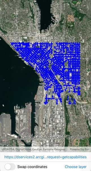
Browse a WFS service for layers and add them to the map.
Use case
Services often have multiple layers available for display. For example, a feature service for a city might have layers representing roads, land masses, building footprints, parks, and facilities. A user can choose to only show the road network and parks for a park accessibility analysis.
How to use the sample
A list of layers in the WFS service will be shown. Select a layer to display.
Some WFS services return coordinates in X,Y order, while others return coordinates in lat/long (Y,X) order. If you don't see features rendered or you see features in the wrong location, use the checkbox to change the coordinate order and reload.
How it works
- Create a
WfsServiceobject with a URL to a WFS feature service. - Obtain a list of
WfsLayerInfofromWfsService.ServiceInfo. - When a layer is selected, create a
WfsFeatureTablefrom theWfsLayerInfo.- Set the axis order if necessary.
- Create a feature layer from the feature table.
- Add the feature layer to the map.
Relevant API
- FeatureLayer
- WfsFeatureTable
- WfsFeatureTable.AxisOrder
- WfsLayerInfo
- WfsService
- WfsServiceInfo
About the data
The sample is configured with a sample WFS service, but you can load other WFS services if desired. The default service shows Seattle downtown features hosted on ArcGIS Online.
Tags
browse, catalog, feature, layers, OGC, service, web, WFS
Sample Code
// Copyright 2019 Esri.
//
// Licensed under the Apache License, Version 2.0 (the "License"); you may not use this file except in compliance with the License.
// You may obtain a copy of the License at: http://www.apache.org/licenses/LICENSE-2.0
//
// Unless required by applicable law or agreed to in writing, software distributed under the License is distributed on an
// "AS IS" BASIS, WITHOUT WARRANTIES OR CONDITIONS OF ANY KIND, either express or implied. See the License for the specific
// language governing permissions and limitations under the License.
using ArcGISRuntime;
using Esri.ArcGISRuntime.Data;
using Esri.ArcGISRuntime.Geometry;
using Esri.ArcGISRuntime.Mapping;
using Esri.ArcGISRuntime.Ogc;
using Esri.ArcGISRuntime.Symbology;
using Esri.ArcGISRuntime.UI.Controls;
using Foundation;
using System;
using System.Diagnostics;
using System.Drawing;
using UIKit;
namespace ArcGISRuntimeXamarin.Samples.BrowseWfsLayers
{
[Register("BrowseWfsLayers")]
[ArcGISRuntime.Samples.Shared.Attributes.Sample(
name: "Browse WFS layers",
category: "Layers",
description: "Browse a WFS service for layers and add them to the map.",
instructions: "A list of layers in the WFS service will be shown. Select a layer to display.",
tags: new[] { "OGC", "WFS", "browse", "catalog", "feature", "layers", "service", "web" })]
public class BrowseWfsLayers : UIViewController
{
// Hold references to UI controls.
private MapView _myMapView;
private UISwitch _toggleAxisOrderSwitch;
private UIActivityIndicatorView _loadingProgressBar;
private UIBarButtonItem _chooseLayersButton;
private UIBarButtonItem _loadServiceButton;
// Hold a reference to the WFS service info - used to get list of available layers.
private WfsServiceInfo _serviceInfo;
// URL to the WFS service.
private const string ServiceUrl = "https://dservices2.arcgis.com/ZQgQTuoyBrtmoGdP/arcgis/services/Seattle_Downtown_Features/WFSServer?service=wfs&request=getcapabilities";
public BrowseWfsLayers()
{
Title = "Browse WFS service for layers";
}
private void Initialize()
{
// Update the UI.
_loadServiceButton.Title = ServiceUrl;
// Create the map with imagery basemap.
_myMapView.Map = new Map(BasemapStyle.ArcGISImageryStandard);
LoadService();
}
private async void LoadService()
{
try
{
_loadingProgressBar.StartAnimating();
_loadServiceButton.Enabled = false;
_chooseLayersButton.Enabled = false;
// Create the WFS service.
WfsService service = new WfsService(new Uri(_loadServiceButton.Title));
// Load the WFS service.
await service.LoadAsync();
// Get the service metadata.
_serviceInfo = service.ServiceInfo;
}
catch (Exception ex)
{
Debug.WriteLine(ex);
new UIAlertView("Error", ex.Message, (IUIAlertViewDelegate)null, "Error loading service", null).Show();
}
finally
{
// Update the UI.
_loadingProgressBar.StopAnimating();
_loadServiceButton.Enabled = true;
_chooseLayersButton.Enabled = true;
}
}
private async void LoadSelectedLayer(WfsLayerInfo selectedLayerInfo)
{
// Show the progress bar.
_loadingProgressBar.StartAnimating();
// Clear the existing layers.
_myMapView.Map.OperationalLayers.Clear();
try
{
// Create the WFS feature table.
WfsFeatureTable table = new WfsFeatureTable(selectedLayerInfo);
// Set the feature request mode to manual - only manual is supported at v100.5.
// In this mode, you must manually populate the table - panning and zooming won't request features automatically.
table.FeatureRequestMode = FeatureRequestMode.ManualCache;
// Set the axis order based on the UI.
if (_toggleAxisOrderSwitch.On)
{
table.AxisOrder = OgcAxisOrder.Swap;
}
else
{
table.AxisOrder = OgcAxisOrder.NoSwap;
}
// Populate the WFS table.
await table.PopulateFromServiceAsync(new QueryParameters(), false, null);
// Create a feature layer from the WFS table.
FeatureLayer wfsFeatureLayer = new FeatureLayer(table);
// Choose a renderer for the layer based on the table.
wfsFeatureLayer.Renderer = GetRendererForTable(table) ?? wfsFeatureLayer.Renderer;
// Add the layer to the map.
_myMapView.Map.OperationalLayers.Add(wfsFeatureLayer);
// Zoom to the extent of the selected layer.
await _myMapView.SetViewpointGeometryAsync(selectedLayerInfo.Extent, 50);
}
catch (Exception ex)
{
Debug.WriteLine(ex);
new UIAlertView("Error", ex.Message, (IUIAlertViewDelegate)null, "Couldn't load layer.", null).Show();
}
finally
{
// Hide the progress bar.
_loadingProgressBar.StopAnimating();
}
}
private void ShowLayerOptions(object sender, EventArgs e)
{
// Create the view controller that will present the list of layers.
UIAlertController layerSelectionAlert = UIAlertController.Create("Select a layer", "", UIAlertControllerStyle.ActionSheet);
// Add an option for each layer.
foreach (WfsLayerInfo layerInfo in _serviceInfo.LayerInfos)
{
// Selecting a layer will call the lambda method, which will show the layer.
layerSelectionAlert.AddAction(UIAlertAction.Create(layerInfo.Title, UIAlertActionStyle.Default, action => LoadSelectedLayer(layerInfo)));
}
// Fix to prevent crash on iPad.
var popoverPresentationController = layerSelectionAlert.PopoverPresentationController;
if (popoverPresentationController != null)
{
popoverPresentationController.BarButtonItem = _chooseLayersButton;
}
// Show the alert.
PresentViewController(layerSelectionAlert, true, null);
}
private Renderer GetRendererForTable(FeatureTable table)
{
switch (table.GeometryType)
{
case GeometryType.Point:
case GeometryType.Multipoint:
return new SimpleRenderer(new SimpleMarkerSymbol(SimpleMarkerSymbolStyle.Circle, Color.Blue, 4));
case GeometryType.Polygon:
case GeometryType.Envelope:
return new SimpleRenderer(new SimpleFillSymbol(SimpleFillSymbolStyle.Solid, Color.Blue, null));
case GeometryType.Polyline:
return new SimpleRenderer(new SimpleLineSymbol(SimpleLineSymbolStyle.Solid, Color.Blue, 1));
}
return null;
}
public override void LoadView()
{
// Create the views.
View = new UIView { BackgroundColor = ApplicationTheme.BackgroundColor };
_myMapView = new MapView();
_myMapView.TranslatesAutoresizingMaskIntoConstraints = false;
_toggleAxisOrderSwitch = new UISwitch();
UILabel axisOrderLabel = new UILabel();
axisOrderLabel.Text = "Swap coordinates";
_chooseLayersButton = new UIBarButtonItem();
_chooseLayersButton.Title = "Choose layer";
_chooseLayersButton.Enabled = false;
_loadServiceButton = new UIBarButtonItem();
UIToolbar loadBar = new UIToolbar();
loadBar.TranslatesAutoresizingMaskIntoConstraints = false;
loadBar.Items = new[]
{
_loadServiceButton
};
UIToolbar toolbar = new UIToolbar();
toolbar.TranslatesAutoresizingMaskIntoConstraints = false;
toolbar.Items = new[]
{
new UIBarButtonItem(_toggleAxisOrderSwitch),
new UIBarButtonItem(UIBarButtonSystemItem.FixedSpace) {Width = 8},
new UIBarButtonItem(axisOrderLabel),
new UIBarButtonItem(UIBarButtonSystemItem.FlexibleSpace),
_chooseLayersButton
};
_loadingProgressBar = new UIActivityIndicatorView(UIActivityIndicatorViewStyle.WhiteLarge);
_loadingProgressBar.TranslatesAutoresizingMaskIntoConstraints = false;
_loadingProgressBar.HidesWhenStopped = true;
_loadingProgressBar.BackgroundColor = UIColor.FromWhiteAlpha(0, .6f);
// Add the views.
View.AddSubviews(_myMapView, loadBar, toolbar, _loadingProgressBar);
// Lay out the views.
NSLayoutConstraint.ActivateConstraints(new[]
{
_myMapView.TopAnchor.ConstraintEqualTo(View.SafeAreaLayoutGuide.TopAnchor),
_myMapView.BottomAnchor.ConstraintEqualTo(loadBar.TopAnchor),
_myMapView.LeadingAnchor.ConstraintEqualTo(View.LeadingAnchor),
_myMapView.TrailingAnchor.ConstraintEqualTo(View.TrailingAnchor),
loadBar.TopAnchor.ConstraintEqualTo(_myMapView.BottomAnchor),
loadBar.BottomAnchor.ConstraintEqualTo(toolbar.TopAnchor),
loadBar.LeadingAnchor.ConstraintEqualTo(View.LeadingAnchor),
loadBar.TrailingAnchor.ConstraintEqualTo(View.TrailingAnchor),
toolbar.TopAnchor.ConstraintEqualTo(loadBar.BottomAnchor),
toolbar.LeadingAnchor.ConstraintEqualTo(View.LeadingAnchor),
toolbar.TrailingAnchor.ConstraintEqualTo(View.TrailingAnchor),
toolbar.BottomAnchor.ConstraintEqualTo(View.SafeAreaLayoutGuide.BottomAnchor),
_loadingProgressBar.TopAnchor.ConstraintEqualTo(View.SafeAreaLayoutGuide.TopAnchor),
_loadingProgressBar.LeadingAnchor.ConstraintEqualTo(View.LeadingAnchor),
_loadingProgressBar.TrailingAnchor.ConstraintEqualTo(View.TrailingAnchor),
_loadingProgressBar.BottomAnchor.ConstraintEqualTo(View.BottomAnchor)
});
}
public override void ViewDidLoad()
{
base.ViewDidLoad();
Initialize();
}
public override void ViewWillAppear(bool animated)
{
base.ViewWillAppear(animated);
// Subscribe to events.
_chooseLayersButton.Clicked += ShowLayerOptions;
_loadServiceButton.Clicked += ServiceLinkClick;
}
private void ServiceLinkClick(object sender, EventArgs e)
{
UIAlertView alert = new UIAlertView()
{
Message = "Enter WFS URL.",
AlertViewStyle = UIAlertViewStyle.PlainTextInput,
CancelButtonIndex = 1
};
alert.GetTextField(0).Text = _loadServiceButton.Title;
alert.AddButton("Load");
alert.AddButton("Cancel");
alert.Clicked += (object s, UIButtonEventArgs a) =>
{
if (a.ButtonIndex != alert.CancelButtonIndex)
{
_loadServiceButton.Title = alert.GetTextField(0).Text;
LoadService();
}
};
alert.Show();
}
public override void ViewDidDisappear(bool animated)
{
base.ViewDidDisappear(animated);
// Unsubscribe from events, per best practice.
_chooseLayersButton.Clicked -= ShowLayerOptions;
_loadServiceButton.Clicked -= ServiceLinkClick;
}
}
}