Update feature attributes in an online feature service.
Use case
Online feature services can be updated with new data. This is useful for updating existing data in real time while working in the field.
How to use the sample
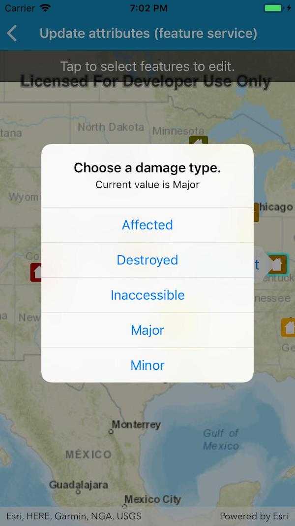
To change the feature's damage property, tap the feature to select it, and update the damage type using the drop down.
How it works
- Create a
ServiceFeatureTableobject from a URL.- When the table loads, you can get the domain to determine which options to present in your UI.
- Create a
FeatureLayerobject from theServiceFeatureTable. - Select features from the
FeatureLayer. - To update the feature's attribute, first load it, then use the
SetAttributeValue. - Update the table with
UpdateFeatureAsync. - After a change, apply the changes on the server using
ApplyEditsAsync.
Relevant API
- ArcGISFeature
- FeatureLayer
- ServiceFeatureTable
Tags
amend, attribute, details, edit, editing, information, value
Sample Code
UpdateAttributes.cs
// Copyright 2019 Esri.
//
// Licensed under the Apache License, Version 2.0 (the "License"); you may not use this file except in compliance with the License.
// You may obtain a copy of the License at: http://www.apache.org/licenses/LICENSE-2.0
//
// Unless required by applicable law or agreed to in writing, software distributed under the License is distributed on an
// "AS IS" BASIS, WITHOUT WARRANTIES OR CONDITIONS OF ANY KIND, either express or implied. See the License for the specific
// language governing permissions and limitations under the License.
using ArcGISRuntime;
using Esri.ArcGISRuntime.Data;
using Esri.ArcGISRuntime.Geometry;
using Esri.ArcGISRuntime.Mapping;
using Esri.ArcGISRuntime.UI.Controls;
using Foundation;
using System;
using System.Collections.Generic;
using System.Linq;
using UIKit;
namespace ArcGISRuntimeXamarin.Samples.UpdateAttributes
{
[Register("UpdateAttributes")]
[ArcGISRuntime.Samples.Shared.Attributes.Sample(
name: "Update attributes (feature service)",
category: "Data",
description: "Update feature attributes in an online feature service.",
instructions: "To change the feature's damage property, tap the feature to select it, and update the damage type using the drop down.",
tags: new[] { "amend", "attribute", "details", "edit", "editing", "information", "value" })]
public class UpdateAttributes : UIViewController
{
// Hold references to UI controls.
private MapView _myMapView;
private UIButton _changeValueButton;
// URL to the feature service.
private const string FeatureServiceUrl = "https://sampleserver6.arcgisonline.com/arcgis/rest/services/DamageAssessment/FeatureServer/0";
// Name of the field that will be updated.
private const string AttributeFieldName = "typdamage";
// Hold a reference to the feature layer.
private FeatureLayer _damageLayer;
// Hold a reference to the selected feature.
private ArcGISFeature _selectedFeature;
// Hold a reference to the domain.
private CodedValueDomain _domain;
public UpdateAttributes()
{
Title = "Update attributes (feature service)";
}
private void Initialize()
{
// Create the map with streets basemap.
_myMapView.Map = new Map(BasemapStyle.ArcGISStreets);
// Create the feature table, referring to the Damage Assessment feature service.
ServiceFeatureTable damageTable = new ServiceFeatureTable(new Uri(FeatureServiceUrl));
// When the table loads, use it to discover the domain of the typdamage field.
damageTable.Loaded += DamageTable_Loaded;
// Create a feature layer to visualize the features in the table.
_damageLayer = new FeatureLayer(damageTable);
// Add the layer to the map.
_myMapView.Map.OperationalLayers.Add(_damageLayer);
// Zoom to the United States.
_myMapView.SetViewpointCenterAsync(new MapPoint(-10800000, 4500000, SpatialReferences.WebMercator), 3e7);
}
private void DamageTable_Loaded(object sender, EventArgs e)
{
// Unsubscribe from event.
((ServiceFeatureTable) sender).Loaded -= DamageTable_Loaded;
// This code needs to work with the UI, so it needs to run on the UI thread.
BeginInvokeOnMainThread(() =>
{
// Get the relevant field from the table.
ServiceFeatureTable table = (ServiceFeatureTable) sender;
Field typeDamageField = table.Fields.First(field => field.Name == AttributeFieldName);
// Get the domain for the field.
_domain = (CodedValueDomain) typeDamageField.Domain;
});
}
private async void MapView_Tapped(object sender, GeoViewInputEventArgs e)
{
// Skip if the sample isn't ready yet.
if (_damageLayer == null) return;
// Clear any existing selection.
_damageLayer.ClearSelection();
// Dismiss any existing callouts.
_myMapView.DismissCallout();
try
{
// Perform an identify to determine if a user tapped on a feature.
IdentifyLayerResult identifyResult = await _myMapView.IdentifyLayerAsync(_damageLayer, e.Position, 8, false);
// Do nothing if there are no results.
if (!identifyResult.GeoElements.Any())
{
return;
}
// Get the tapped feature.
_selectedFeature = (ArcGISFeature) identifyResult.GeoElements.First();
// Select the feature.
_damageLayer.SelectFeature(_selectedFeature);
// Update the UI for the selection.
ShowFeatureCallout();
}
catch (Exception ex)
{
ShowMessage("Error selecting feature.", ex.ToString());
}
}
private void ShowFeatureCallout()
{
// Get the current value.
string currentAttributeValue = _selectedFeature.Attributes[AttributeFieldName].ToString();
// Unsubscribe from previous event handler.
if (_changeValueButton != null) _changeValueButton.TouchUpInside -= ShowDamageTypeChoices;
// Set up the UI for the callout.
_changeValueButton = new UIButton();
_changeValueButton.SetTitle($"{currentAttributeValue} - Edit", UIControlState.Normal);
_changeValueButton.SetTitleColor(View.TintColor, UIControlState.Normal);
_changeValueButton.TouchUpInside += ShowDamageTypeChoices;
// Show the callout.
_myMapView.ShowCalloutAt((MapPoint) _selectedFeature.Geometry, _changeValueButton);
}
private void ShowDamageTypeChoices(object sender, EventArgs e)
{
// Show the currently selected attribute value.
string message = $"Current value is {_selectedFeature.Attributes[AttributeFieldName]}";
// Create the alert controller - will show current value and the options for changing the value.
UIAlertController alertController = UIAlertController.Create("Choose a damage type.", message, UIAlertControllerStyle.Alert);
// Get the list of valid choices - all of the coded values that aren't currently selected.
IEnumerable<CodedValue> possibleChoices = _domain.CodedValues.Where(value => value.Name != _selectedFeature.Attributes[AttributeFieldName].ToString());
// Add an action (shows as button) for every choice.
foreach (CodedValue codeValue in possibleChoices)
{
alertController.AddAction(UIAlertAction.Create(codeValue.Name, UIAlertActionStyle.Default, action => UpdateDamageType(codeValue.Name)));
}
// Allow the user to cancel.
alertController.AddAction(UIAlertAction.Create("Cancel", UIAlertActionStyle.Cancel, null));
// Show the alert.
PresentViewController(alertController, true, null);
}
private async void UpdateDamageType(string selectedAttributeValue)
{
try
{
// Load the feature.
await _selectedFeature.LoadAsync();
// Update the attribute value.
_selectedFeature.SetAttributeValue(AttributeFieldName, selectedAttributeValue);
// Update the table.
await _selectedFeature.FeatureTable.UpdateFeatureAsync(_selectedFeature);
// Update the service.
ServiceFeatureTable table = (ServiceFeatureTable) _selectedFeature.FeatureTable;
await table.ApplyEditsAsync();
ShowMessage("Success!", $"Edited feature {_selectedFeature.Attributes["objectid"]}");
}
catch (Exception ex)
{
ShowMessage("Failed to edit feature", ex.ToString());
}
finally
{
// Clear the selection.
_damageLayer.ClearSelection();
_selectedFeature = null;
// Dismiss any callout.
_myMapView.DismissCallout();
}
}
private void ShowMessage(string title, string message)
{
// Create the alert controller.
UIAlertController alertController = UIAlertController.Create(title, message, UIAlertControllerStyle.Alert);
alertController.AddAction(UIAlertAction.Create("OK", UIAlertActionStyle.Default, null));
// Show the alert.
PresentViewController(alertController, true, null);
}
public override void ViewDidLoad()
{
base.ViewDidLoad();
Initialize();
}
public override void LoadView()
{
// Create the views.
View = new UIView() { BackgroundColor = ApplicationTheme.BackgroundColor };
_myMapView = new MapView();
_myMapView.TranslatesAutoresizingMaskIntoConstraints = false;
UILabel helpLabel = new UILabel
{
Text = "Tap to select features to edit.",
AdjustsFontSizeToFitWidth = true,
TextAlignment = UITextAlignment.Center,
BackgroundColor = UIColor.FromWhiteAlpha(0, .6f),
TextColor = UIColor.White,
Lines = 1,
TranslatesAutoresizingMaskIntoConstraints = false
};
// Add the views.
View.AddSubviews(_myMapView, helpLabel);
// Lay out the views.
NSLayoutConstraint.ActivateConstraints(new[]
{
_myMapView.TopAnchor.ConstraintEqualTo(View.SafeAreaLayoutGuide.TopAnchor),
_myMapView.BottomAnchor.ConstraintEqualTo(View.BottomAnchor),
_myMapView.LeadingAnchor.ConstraintEqualTo(View.LeadingAnchor),
_myMapView.TrailingAnchor.ConstraintEqualTo(View.TrailingAnchor),
helpLabel.TopAnchor.ConstraintEqualTo(View.SafeAreaLayoutGuide.TopAnchor),
helpLabel.LeadingAnchor.ConstraintEqualTo(View.LeadingAnchor),
helpLabel.TrailingAnchor.ConstraintEqualTo(View.TrailingAnchor),
helpLabel.HeightAnchor.ConstraintEqualTo(40)
});
}
public override void ViewWillAppear(bool animated)
{
base.ViewWillAppear(animated);
// Subscribe to events.
_myMapView.GeoViewTapped += MapView_Tapped;
if (_changeValueButton != null) _changeValueButton.TouchUpInside += ShowDamageTypeChoices;
}
public override void ViewDidDisappear(bool animated)
{
base.ViewDidDisappear(animated);
// Unsubscribe from events, per best practice.
_myMapView.GeoViewTapped -= MapView_Tapped;
if (_changeValueButton != null) _changeValueButton.TouchUpInside -= ShowDamageTypeChoices;
}
}
}