Browse a WFS service for layers and add them to the map.
Use case
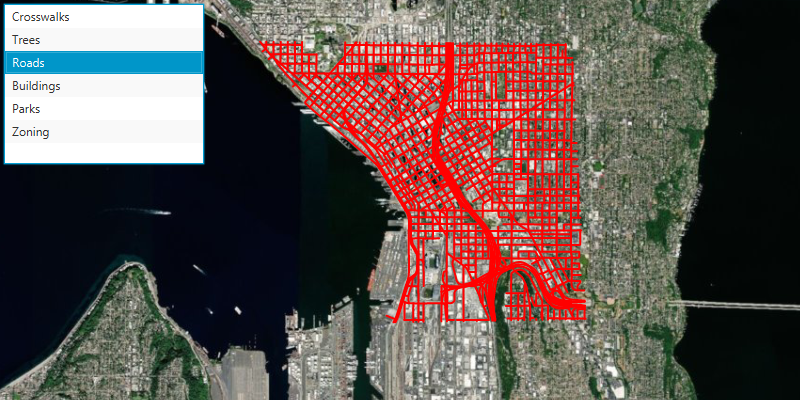
Services often have multiple layers available for display. For example, a feature service for a city might have layers representing roads, land masses, building footprints, parks, and facilities. A user can choose to only show the road network and parks for a park accessibility analysis.
How to use the sample
A list of layers in the WFS service will be shown. Select a layer to display it.
How it works
- Create a
WfsServiceobject with a URL to a WFS feature service. - Obtain a list of
WfsLayerInfofromWfsService.getServiceInfo().getLayerInfos(). - When a layer is selected, create a
WfsFeatureTablefrom theWfsLayerInfo. - Create a feature layer from the feature table.
- Add the feature layer to the map.
Relevant API
- FeatureLayer
- WfsFeatureTable
- WfsLayerInfo
- WfsService
- WfsServiceInfo
About the data
The sample is configured with a sample WFS service, but you can load other WFS services if desired. The default service shows Seattle downtown features hosted on ArcGIS Online.
Tags
browse, catalog, feature, layers, OGC, service, web, WFS
Sample Code
/* * Copyright 2022 Esri. * * Licensed under the Apache License, Version 2.0 (the "License"); * you may not use this file except in compliance with the License. * You may obtain a copy of the License at * * http://www.apache.org/licenses/LICENSE-2.0 * * Unless required by applicable law or agreed to in writing, software * distributed under the License is distributed on an "AS IS" BASIS, * WITHOUT WARRANTIES OR CONDITIONS OF ANY KIND, either express or implied. * See the License for the specific language governing permissions and * limitations under the License. */module com.esri.samples.browse_wfs_layers {  // require ArcGIS Maps SDK for Java module  requires com.esri.arcgisruntime;
  // handle SLF4J http://www.slf4j.org/codes.html#StaticLoggerBinder  requires org.slf4j.nop;
  // require JavaFX modules that the application uses  requires javafx.graphics;  requires javafx.controls;
  exports com.esri.samples.browse_wfs_layers;}
/* * Copyright 2019 Esri. * * Licensed under the Apache License, Version 2.0 (the "License"); you may not * use this file except in compliance with the License. You may obtain a copy of * the License at * * http://www.apache.org/licenses/LICENSE-2.0 * * Unless required by applicable law or agreed to in writing, software * distributed under the License is distributed on an "AS IS" BASIS, WITHOUT * WARRANTIES OR CONDITIONS OF ANY KIND, either express or implied. See the * License for the specific language governing permissions and limitations under * the License. */
package com.esri.samples.browse_wfs_layers;
import javafx.application.Application;import javafx.geometry.Insets;import javafx.geometry.Pos;import javafx.scene.Scene;import javafx.scene.control.Alert;import javafx.scene.control.ListCell;import javafx.scene.control.ListView;import javafx.scene.control.ProgressIndicator;import javafx.scene.layout.StackPane;import javafx.scene.paint.Color;import javafx.stage.Stage;
import com.esri.arcgisruntime.ArcGISRuntimeEnvironment;import com.esri.arcgisruntime.data.QueryParameters;import com.esri.arcgisruntime.data.ServiceFeatureTable;import com.esri.arcgisruntime.layers.FeatureLayer;import com.esri.arcgisruntime.loadable.LoadStatus;import com.esri.arcgisruntime.mapping.ArcGISMap;import com.esri.arcgisruntime.mapping.BasemapStyle;import com.esri.arcgisruntime.mapping.view.MapView;import com.esri.arcgisruntime.ogc.wfs.OgcAxisOrder;import com.esri.arcgisruntime.ogc.wfs.WfsFeatureTable;import com.esri.arcgisruntime.ogc.wfs.WfsLayerInfo;import com.esri.arcgisruntime.ogc.wfs.WfsService;import com.esri.arcgisruntime.symbology.SimpleFillSymbol;import com.esri.arcgisruntime.symbology.SimpleLineSymbol;import com.esri.arcgisruntime.symbology.SimpleMarkerSymbol;import com.esri.arcgisruntime.symbology.SimpleRenderer;
import java.util.List;
public class BrowseWfsLayersSample extends Application {
private MapView mapView; private ArcGISMap map; private ProgressIndicator wfsServiceIndicator, wfsTableIndicator;
// keep loadables in scope to avoid garbage collection private WfsService wfsService; private WfsFeatureTable wfsFeatureTable;
@Override public void start(Stage stage) throws Exception {
// create stack pane and JavaFX app scene StackPane stackPane = new StackPane(); Scene scene = new Scene(stackPane); scene.getStylesheets().add(getClass().getResource("/browse_wfs_layers/style.css").toExternalForm());
// set title, size, and add JavaFX scene to stage stage.setTitle("Browse WFS Layers"); stage.setWidth(800); stage.setHeight(700); stage.setScene(scene); stage.show();
// authentication with an API key or named user is required to access basemaps and other location services String yourAPIKey = System.getProperty("apiKey"); ArcGISRuntimeEnvironment.setApiKey(yourAPIKey);
// create a list view to show all the layers in a WFS service ListView<WfsLayerInfo> wfsLayerNamesListView = new ListView<>(); wfsLayerNamesListView.setMaxSize(200, 160);
// create progress indicators wfsServiceIndicator = new ProgressIndicator(); wfsTableIndicator = new ProgressIndicator(); wfsTableIndicator.setVisible(false);
// create a map with the standard imagery basemap style map = new ArcGISMap(BasemapStyle.ARCGIS_IMAGERY_STANDARD);
// create a map view and set the map to it mapView = new MapView(); mapView.setMap(map);
// create a WFS service with a URL and load it wfsService = new WfsService("https://dservices2.arcgis.com/ZQgQTuoyBrtmoGdP/arcgis/services/Seattle_Downtown_Features/WFSServer?service=wfs&request=getcapabilities"); wfsService.loadAsync();
// show the progress indicator when the WFS service is loading wfsServiceIndicator.visibleProperty().bind(wfsService.loadStatusProperty().isEqualTo(LoadStatus.LOADING));
// when the WFS service has loaded, add its layer information to the list view for browsing wfsService.loadStatusProperty().addListener((observable, oldValue, newValue) -> { if (newValue == LoadStatus.LOADED) { // add the list of WFS layers to the list view List<WfsLayerInfo> wfsLayerInfos = wfsService.getServiceInfo().getLayerInfos(); wfsLayerNamesListView.getItems().addAll(wfsLayerInfos); } else if (newValue == LoadStatus.FAILED_TO_LOAD) { new Alert(Alert.AlertType.ERROR, "WFS Service Failed to Load!\n" + wfsService.loadErrorProperty().get().getCause().getMessage()).show(); } });
// populate the list view with layer names wfsLayerNamesListView.setCellFactory(list -> new ListCell<>() {
@Override protected void updateItem(WfsLayerInfo wfsLayerInfo, boolean bln) { super.updateItem(wfsLayerInfo, bln); if (wfsLayerInfo != null) { String fullNameOfWfsLayer = wfsLayerInfo.getName(); String[] split = fullNameOfWfsLayer.split(":"); String smallName = split[1]; setText(smallName); } } });
// load the selected layer from the list view when the layer is selected wfsLayerNamesListView.getSelectionModel().selectedItemProperty().addListener(observable -> updateMap(wfsLayerNamesListView.getSelectionModel().getSelectedItem()) );
// add the controls to the stack pane stackPane.getChildren().addAll(mapView, wfsLayerNamesListView, wfsServiceIndicator, wfsTableIndicator); StackPane.setAlignment(wfsLayerNamesListView, Pos.TOP_LEFT); StackPane.setMargin(wfsLayerNamesListView, new Insets(10)); }
/** * Adds a WfsLayerInfo to the map's operational layers, with a random color renderer. * @param wfsLayerInfo the WfsLayerInfo that the map will display */ private void updateMap(WfsLayerInfo wfsLayerInfo){
// show progress indicator when populating feature table wfsTableIndicator.setVisible(true);
// clear the map's operational layers map.getOperationalLayers().clear();
// create a WFSFeatureTable from the WFSLayerInfo wfsFeatureTable = new WfsFeatureTable(wfsLayerInfo);
// set the feature request mode to manual. The table must be manually populated as panning and zooming won't request features automatically. wfsFeatureTable.setFeatureRequestMode(ServiceFeatureTable.FeatureRequestMode.MANUAL_CACHE); // define the coordinate order for the WFS service wfsFeatureTable.setAxisOrder(OgcAxisOrder.NO_SWAP);
// create a feature layer to visualize the WFS features FeatureLayer wfsFeatureLayer = new FeatureLayer(wfsFeatureTable);
// populate the table and set the viewpoint to that of the layer's full extent when done. wfsFeatureTable.populateFromServiceAsync(new QueryParameters(), false, null ).addDoneListener(()->{ wfsTableIndicator.setVisible(false); mapView.setViewpointGeometryAsync(wfsFeatureLayer.getFullExtent(), 50); });
// apply a renderer to the feature layer once the table is loaded (the renderer is based on the table's geometry type) wfsFeatureTable.addDoneLoadingListener(()->{ switch (wfsFeatureTable.getGeometryType()) { case POINT: wfsFeatureLayer.setRenderer(new SimpleRenderer(new SimpleMarkerSymbol(SimpleMarkerSymbol.Style.CIRCLE, Color.AQUA, 4))); break; case POLYGON: wfsFeatureLayer.setRenderer(new SimpleRenderer(new SimpleFillSymbol(SimpleFillSymbol.Style.SOLID, Color.YELLOW, null))); break; case POLYLINE: wfsFeatureLayer.setRenderer(new SimpleRenderer(new SimpleLineSymbol(SimpleLineSymbol.Style.SOLID, Color.RED, 2))); break; } });
// add the layer to the map's operational layers map.getOperationalLayers().add(wfsFeatureLayer); }
/** * Stops and releases all resources used in application. */ @Override public void stop() { if (mapView != null) { mapView.dispose(); } }
/** * Opens and runs application. * * @param args arguments passed to this application */ public static void main(String[] args) {
Application.launch(args); }}