Follow step-by-step instructions to build apps that incorporate ArcGIS Maps functionality.
Maps
Create a map that displays one of the many basemaps available from the basemap styles service
Display a map
Create a map that uses a basemap service layer and zoom to a specified location.

Add a point, line, and polygon
Add shapes (graphics) to represent features on the map.
Display a web map
Display a preauthored map stored as an ArcGIS Online portal item.
Scenes
Display data in 3D with a scene.

Display a scene
Create a scene that uses a basemap service layer and zoom to a specified location.

Display a web scene
Display a preauthored scene stored as an ArcGIS Online portal item.
Layers
Add additional datasets to your map or scene.
Add a feature layer
Display feature service data hosted on ArcGIS Online.

Style a feature layer
Use symbols and renderers to create custom styling for a feature layer.

Add a feature layer from a portal item
Display a feature layer with preauthored styling and saved as an ArcGIS Online portal item.
Query
Query features using spatial and/or attribute
Search and location
Show the current device location. Find addresses, businesses, and places with the Geocoding service
Display device location
Show the location of the device that is running your app.

Search for an address
Display the geographic location for an address string.

Find places
Locate businesses, addresses, or points-of-interest on the map.
Routing
Find routes and directions with the Routing service

Spatial and data analysis
Work with geographic data to analyze spatial relationships or make measurements.

Display a viewshed
Find areas of a scene that are hidden or visible based on terrain and 3D objects.

Display a line of sight
Show where the view is obstructed along a line between two locations in a scene.

Measure a distance in 3D
Interactively measure the vertical, horizontal, and direct distance between points in a scene.
Offline
Use tools to prepare data for offline use. Build applications to display, analyze, and edit data locally without an internet connection.
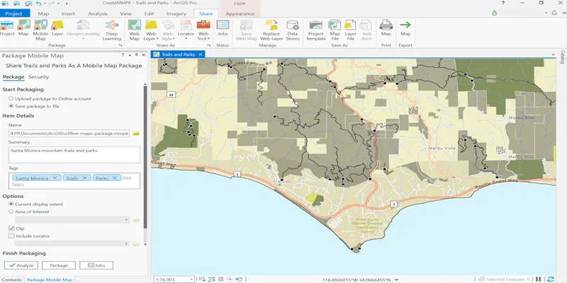
Create a mobile map package
Use ArcGIS Pro to package a map for offline use.

Create an offline map area
Use ArcGIS Online to create an offline map area for your app users.

Display a map from a mobile map package
Display a map that’s been packaged for offline use.

Display an offline map (on-demand)
Download and display an offline map for a specified geographic area.
Security and authentication
Implement user authentication
