Learn how to display the current device location on a map
You can display the device location on a map or scene. This is important for workflows that require the user’s current location, such as finding nearby businesses, navigating from the current location, or identifying and collecting geospatial information.
By default, location display uses the device’s location provider. Your app can also process input from other location providers, such as an external GPS receiver or a provider that returns a simulated location. For more information, see the Show device location topic.
Prerequisites
Before starting this tutorial:
-
You need an ArcGIS Location Platform or ArcGIS Online account.
-
Your system meets the system requirements.
Develop or Download
You have two options for completing this tutorial:
Option 1: Develop the code
To start the tutorial, complete the Display a map tutorial. This creates a map to display the Santa Monica Mountains in California using the topographic basemap from the ArcGIS Basemap Styles service
Open an Xcode project
- Open the
.xcodeprojproject you created by completing the Display a map tutorial. - Continue with the following instructions to display the current device location on a map or scene.
Add a custom iOS target property
The app must provide a message that tells the user why the app is requesting access to the user’s location when the app is in use.
-
In Xcode, in the Project navigator, select the target app.
-
Click the Info tab and add the “Privacy - Location When In Use Usage Description” key under Custom iOS Target Properties.
-
Add a string value describing how the app would use the device location. For example, “Your location is used to show your position on the map.”
To learn more about requesting user authorization, see the Note in the Location data sources section of the Device location guide topic.
Import Core Location
-
In Xcode, in the Project Navigator, click ContentView.swift.
-
In the Editor, import the CoreLocation framework. This is required to request the user’s location.
ContentView.swiftimport ArcGISimport CoreLocation
Initialize the map
-
The map will zoom to the extent
An extent is a bounding rectangle with points that delineate an area for a map or scene. of the current location, so you don’t need to set the viewpoint anymore. Remove the mapStateObjectand replace it with just a map initializer.ContentView.swiftstruct ContentView: View {private let map = Map(basemapStyle: .arcGISTopographic)
Add location display to map view
-
Create the location display using the system location data source.
ContentView.swiftstruct ContentView: View {private let map = Map(basemapStyle: .arcGISTopographic)private let locationDisplay = LocationDisplay(dataSource: SystemLocationDataSource()) -
Add the location display modifier to the map view.
ContentView.swiftvar body: some View {MapView(map: map).locationDisplay(locationDisplay)}}
Request user authorization to use location
The app must request authorization from the user to access the device location. The user can grant or deny the request.
-
In the task modifier, create a
CLLocationManager. -
If the authorization status is not determined, request “in use authorization”.
ContentView.swiftvar body: some View {MapView(map: map).locationDisplay(locationDisplay).task {let locationManager = CLLocationManager()if locationManager.authorizationStatus == .notDetermined {locationManager.requestWhenInUseAuthorization()}}}
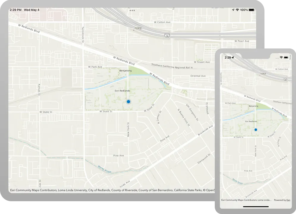
Show the current location
A map viewLocationDisplay for showing the current location of the device
Instances of this class manage the display of device location on a map view: the symbols, animation, auto pan behavior, and so on. Location display is an overlay of the map view, and displays above everything else, including graphics overlays.
The location display does not retrieve location information, that is the job of the associated data source, which provides location updates on a regular basis. In addition to the default system location data source, you can use location providers based on external GPS devices or a simulated location source.
Each map view has its own instance of a location display and instances of location display and location data source are not shared by multiple map views. This allows you to start and stop location display independently on multiple map views without affecting each other.
-
Start displaying the location by calling the data source’s
start()method.ContentView.swiftvar body: some View {MapView(map: map).locationDisplay(locationDisplay).task {let locationManager = CLLocationManager()if locationManager.authorizationStatus == .notDetermined {locationManager.requestWhenInUseAuthorization()}do {try await locationDisplay.dataSource.start()} catch {}}} -
Set the initial zoom scale and the auto pan mode.
ContentView.swiftvar body: some View {MapView(map: map).locationDisplay(locationDisplay).task {let locationManager = CLLocationManager()if locationManager.authorizationStatus == .notDetermined {locationManager.requestWhenInUseAuthorization()}do {try await locationDisplay.dataSource.start()locationDisplay.initialZoomScale = 40_000locationDisplay.autoPanMode = .recenter} catch {}}}
Error handling
-
Add a
BoolcalledfailedToStart.ContentView.swiftstruct ContentView: View {private let map = Map(basemapStyle: .arcGISTopographic)private let locationDisplay = LocationDisplay(dataSource: SystemLocationDataSource())@State private var failedToStart = false -
In the catch closure, set the
failedToStartboolean to true. If the location display fails to start, the value will be changed.ContentView.swiftdo {try await locationDisplay.dataSource.start()locationDisplay.initialZoomScale = 40_000locationDisplay.autoPanMode = .recenter} catch {self.failedToStart = true} -
Present an alert if the location display failed to start.
ContentView.swift31 collapsed lines// Copyright 2022 Esri//// Licensed under the Apache License, Version 2.0 (the "License");// you may not use this file except in compliance with the License.// You may obtain a copy of the License at//// https://www.apache.org/licenses/LICENSE-2.0//// Unless required by applicable law or agreed to in writing, software// distributed under the License is distributed on an "AS IS" BASIS,// WITHOUT WARRANTIES OR CONDITIONS OF ANY KIND, either express or implied.// See the License for the specific language governing permissions and// limitations under the License.import SwiftUIimport ArcGISimport CoreLocationstruct ContentView: View {private let map = Map(basemapStyle: .arcGISTopographic)private let locationDisplay = LocationDisplay(dataSource: SystemLocationDataSource())@State private var failedToStart = falsevar body: some View {MapView(map: map).locationDisplay(locationDisplay).task {let locationManager = CLLocationManager()if locationManager.authorizationStatus == .notDetermined {locationManager.requestWhenInUseAuthorization()}do {try await locationDisplay.dataSource.start()locationDisplay.initialZoomScale = 40_000locationDisplay.autoPanMode = .recenter} catch {self.failedToStart = true}}.alert("Location display failed to start", isPresented: $failedToStart) {}}2 collapsed lines}
Run the solution
-
Press Command + R to run the app.
If you are using the Xcode simulator your system must meet these minimum requirements: macOS 14 (Sonoma), Xcode 16, iOS 18. If you are using a physical device, then refer to the system requirements.
-
When the app runs, you’ll see the system prompt requesting to use the device location. Tap to either Allow once or While using the app.
-
If the app is running on a simulator, you’ll have to provide a simulated location. Go to the Features menu of the Simulator. Under Location, choose a predefined option or enter a custom Location.
Your map should now show the device’s location, either simulated or actual.
Alternatively, you can download the tutorial solution, as follows.
Option 2: Download the solution
-
Click the
Download solutionlink under Solution and unzip the file to a location on your machine. -
Open the
.xcodeprojfile in Xcode.
Since the downloaded solution does not contain authentication credentials, you must first set up authentication to create credentials, and then add the developer credentials to the solution.
Set up authentication
To access the secure ArcGIS location services
You can implement API key authentication or user authentication in this tutorial. Compare the differences below:
API key authentication
- Users are not required to sign in.
- Requires creating an API key credential
API key credentials are an item that contains the parameters used to create and manage long-lived access tokens for API key authentication. They are a type of developer credential. with the correct privileges. - API keys
An API key is a long-lived access token created using API key credentials. They are valid for up to one year and are typically embedded directly into client applications. are long-lived access tokens. - Service usage is billed to the API key owner/developer.
- Simplest authentication method to implement.
- Recommended approach for new ArcGIS developers.
Learn more in API key authentication.
User authentication
- Users are required to sign in with an ArcGIS account
An ArcGIS account is an identity with a user type and set of privileges that can access specific ArcGIS products, tools, APIs, services, and resources. The main account types that can be used for development are an ArcGIS Location Platform account, ArcGIS Online account, and ArcGIS Enterprise account. ArcGIS Location Platform and ArcGIS Online accounts are also associated with a subscription. . - User accounts must have privilege
Privileges are a set of permissions assigned to ArcGIS accounts, developer credentials, and applications that grant access to secure resources and functionality in ArcGIS. to access the ArcGIS servicesA service, also known as an ArcGIS service, is software that supports an ArcGIS REST API and provides geospatial functionality or data. A service can be hosted by Esri or in ArcGIS Enterprise. used in application. - Requires creating OAuth credentials
OAuth credentials are an item that contains parameters required to implement user authentication or app authentication, including a .client_id,client_secret, and redirect URIs. They are a type of developer credential. - Application uses a redirect URL and client ID.
- Service usage is billed to the organization of the user signed into the application.
Learn more in User authentication.
To complete this tutorial, click on the tab in the switcher below for your authentication type of choice, either API key authentication or User authentication.
Create a new API key access token
-
Complete the Create an API key tutorial and create an API key with the following privilege(s)
Privileges are a set of permissions assigned to ArcGIS accounts, developer credentials, and applications that grant access to secure resources and functionality in ArcGIS. :- Privileges
- Location services > Basemaps
- Privileges
-
Copy and paste the API key access token into a safe location. It will be used in a later step.
Create new OAuth credentials to access the secure resources used in this tutorial.
-
Complete the Create OAuth credentials for user authentication tutorial to obtain a Client ID and Redirect URL.
A
Client IDuniquely identifies your app on the authenticating server. If the server cannot find an app with the provided Client ID, it will not proceed with authentication.The
Redirect URL(also referred to as a callback url) is used to identify a response from the authenticating server when the system returns control back to your app after an OAuth login. Since it does not necessarily represent a valid endpoint that a user could navigate to, the redirect URL can use a custom scheme, such asmy-app://auth. It is important to make sure the redirect URL used in your app’s code matches a redirect URL configured on the authenticating server. -
Copy and paste the Client ID and Redirect URL into a safe location. They will be used in a later step.
All users that access this application need account privileges
Set developer credentials in the solution
To allow your app users to access ArcGIS location services
Pass your API Key access token to the ArcGISEnvironment.
-
In the Project Navigator, click MainApp.swift.
-
Set the
AuthenticationModeto.apiKey.MainApp.swift// Change the `AuthenticationMode` to `.apiKey` if your application uses API key authentication.private var authenticationMode: AuthenticationMode { .apiKey } -
Set the
apiKeyproperty with your API key access token.MainApp.swift31 collapsed lines// Copyright 2022 Esri//// Licensed under the Apache License, Version 2.0 (the "License");// you may not use this file except in compliance with the License.// You may obtain a copy of the License at//// https://www.apache.org/licenses/LICENSE-2.0//// Unless required by applicable law or agreed to in writing, software// distributed under the License is distributed on an "AS IS" BASIS,// WITHOUT WARRANTIES OR CONDITIONS OF ANY KIND, either express or implied.// See the License for the specific language governing permissions and// limitations under the License.import SwiftUIimport ArcGISimport ArcGISToolkit@mainstruct MainApp: App {// The authentication mode.private enum AuthenticationMode {case apiKeycase user}// Change the `AuthenticationMode` to `.apiKey` if your application uses API key authentication.private var authenticationMode: AuthenticationMode { .apiKey }// Please enter an API key access token if your application uses API key authentication.private let apiKey = APIKey("<#YOUR-ACCESS-TOKEN#>")43 collapsed lines// Setup an `Authenticator` with OAuth configuration if your application uses OAuth credentials.@ObservedObject var authenticator = Authenticator(oAuthUserConfigurations: [OAuthUserConfiguration(// Please enter OAuth credentials for user authentication.portalURL: URL(string: "<#YOUR-PORTAL-URL#>")!,clientID: "<#YOUR-CLIENT-ID#>",redirectURL: URL(string: "<#YOUR-REDIRECT-URL#>")!)])func setAuthentication() {switch authenticationMode {case .apiKey:ArcGISEnvironment.apiKey = apiKeycase .user:ArcGISEnvironment.authenticationManager.arcGISAuthenticationChallengeHandler = authenticator}}init() {setAuthentication()}var body: some SwiftUI.Scene {WindowGroup {ContentView().authenticator(authenticator).ignoresSafeArea()}}}
Best Practice: The access token is stored directly in the code as a convenience for this tutorial. Do not store credentials directly in source code in a production environment.
Use the Authenticator toolkit component to manage your OAuth credentialsclient_id, client_secret, and redirect URIs. They are a type of developer credential. ArcGISEnvironment.
-
In the Project Navigator, click MainApp.swift.
-
Set the
AuthenticationModeto.user.MainApp.swift// Change the `AuthenticationMode` to `.user` if your application uses OAuth credentials.private var authenticationMode: AuthenticationMode { .user } -
Set your
portalURL,clientIDandredirectURLvalues.MainApp.swift36 collapsed lines// Copyright 2022 Esri//// Licensed under the Apache License, Version 2.0 (the "License");// you may not use this file except in compliance with the License.// You may obtain a copy of the License at//// https://www.apache.org/licenses/LICENSE-2.0//// Unless required by applicable law or agreed to in writing, software// distributed under the License is distributed on an "AS IS" BASIS,// WITHOUT WARRANTIES OR CONDITIONS OF ANY KIND, either express or implied.// See the License for the specific language governing permissions and// limitations under the License.import SwiftUIimport ArcGISimport ArcGISToolkit@mainstruct MainApp: App {// The authentication mode.private enum AuthenticationMode {case apiKeycase user}// Change the `AuthenticationMode` to `.user` if your application uses OAuth credentials.private var authenticationMode: AuthenticationMode { .apiKey }// Please enter an API key access token if your application uses API key authentication.private let apiKey = APIKey("<#YOUR-ACCESS-TOKEN#>")// Setup an `Authenticator` with OAuth configuration if your application uses OAuth credentials.@ObservedObject var authenticator = Authenticator(oAuthUserConfigurations: [OAuthUserConfiguration(// Please enter OAuth credentials for user authentication.portalURL: URL(string: "<#YOUR-PORTAL-URL#>")!,clientID: "<#YOUR-CLIENT-ID#>",redirectURL: URL(string: "<#YOUR-REDIRECT-URL#>")!)])28 collapsed linesfunc setAuthentication() {switch authenticationMode {case .apiKey:ArcGISEnvironment.apiKey = apiKeycase .user:ArcGISEnvironment.authenticationManager.arcGISAuthenticationChallengeHandler = authenticator}}init() {setAuthentication()}var body: some SwiftUI.Scene {WindowGroup {ContentView().authenticator(authenticator).ignoresSafeArea()}}}
Best Practice: The OAuth credentials are stored directly in the code as a convenience for this tutorial. Do not store credentials directly in source code in a production environment.
Run the solution
-
Press Command + R to run the app.
If you are using the Xcode simulator your system must meet these minimum requirements: macOS 14 (Sonoma), Xcode 16, iOS 18. If you are using a physical device, then refer to the system requirements.
-
When the app runs, you’ll see the system prompt requesting to use the device location. Tap to either Allow once or While using the app.
-
If the app is running on a simulator, you’ll have to provide a simulated location. Go to the Features menu of the Simulator. Under Location, choose a predefined option or enter a custom Location.
Your map should now show the device’s location, either simulated or actual.
What’s next?
Learn how to use additional API features, ArcGIS location services, and ArcGIS tools in these tutorials: