A utility network A utility network is a feature service that represents a utility system, such as water, gas, or electricity. A utility network provides the capabilities to visualize, edit, and analyze utility assets and data. Learn more is the main component users work with when managing utility and telecom networks in ArcGIS, providing a comprehensive framework for the modeling of utility systems such as electric, gas, water, storm water, wastewater, and telecommunications. It is designed to model all of the components that make up your system—such as wires, pipes, valves, zones, devices, and circuits—and allows you to build real-world behavior into the network features you model.

You must use ArcGIS Pro ArcGIS Pro is a professional desktop GIS application that can explore, visualize, analyze, and manage 2D and 3D data. Learn more to create a utility network A utility network is a feature service that represents a utility system, such as water, gas, or electricity. A utility network provides the capabilities to visualize, edit, and analyze utility assets and data. Learn more . Build your utility network within an enterprise geodatabase A geodatabase is a spatial data storage format that can contain multiple datasets of geographic features and non-spatial tabular data, as well as attachments, field domain definitions, and relationships between layers/tables. Learn more then publish it using ArcGIS Enterprise ArcGIS Enterprise is a GIS mapping, analytics, data hosting, and content management product that can be hosted on-premise or in a cloud infrastructure. It includes software, applications, tools, APIs, and services for users and developers. Learn more . Once it’s available as a feature service A feature service is a data service that provides access to spatial and non-spatial data in feature layers, feature layer views, and tables. Learn more , a utility network can be used in your ArcGIS Maps SDK for Swift app.

See the following topics in the ArcGIS Pro documentation for more information about utility networks:

Utility network

Using ArcGIS Maps SDK for Swift, you can add the following utility network A utility network is a feature service that represents a utility system, such as water, gas, or electricity. A utility network provides the capabilities to visualize, edit, and analyze utility assets and data. Learn more capabilities to your app:

  • Display a utility network—Visualize assets on a map and see how assets are connected.
  • Get associated utility elements—Explore associations 
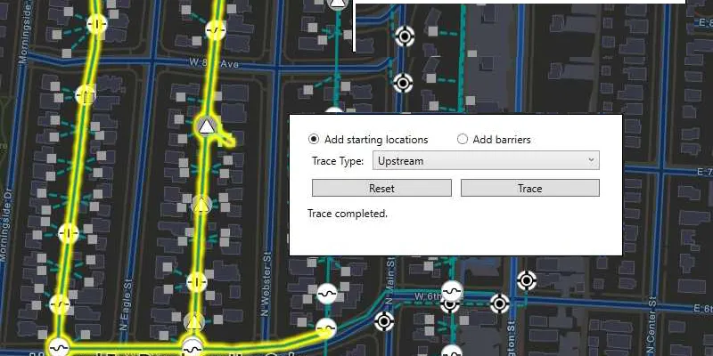
An association is a relationship between two elements that is reflected in a utility network topology. Learn more that model connectivity, containment, and attachment between utility elements A utility element is an entity in a utility network that corresponds to a feature or a part of a feature (for example, a terminal inside a device). Learn more .
  • Trace a utility network—Analyze how resources, such as gas, water, or electricity flow through the network.
  • Take a utility network offline—Take utility network information offline Offline is the state of having no network connection and applications cannot access ArcGIS Online or ArcGIS Enterprise. Learn more and work with it while disconnected. Display and query associations, make simple edits to utility network features, and synchronize edits with ArcGIS Enterprise ArcGIS Enterprise is a GIS mapping, analytics, data hosting, and content management product that can be hosted on-premise or in a cloud infrastructure. It includes software, applications, tools, APIs, and services for users and developers. Learn more .

Consult the Licensing levels and capabilities topic to help determine how your app must be licensed when working with a utility network.

Samples