Swift Package Manager
The ArcGIS Maps SDK for Swift can be easily integrated into your Xcode project using Swift Package Manager.
Xcode 26
-
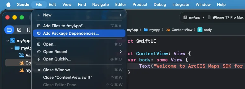
Open your Xcode project. In the menu bar, select File > Add Package Dependencies…
-
In the search bar, enter
https://github.com/Esri/arcgis-maps-sdk-swiftas the package repository URL. -
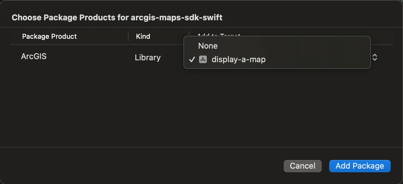
Optionally, select an option for the Dependency Rule if you want to specify an exact version or a range of versions to use.
-
Click Add Package
-
Select the app from the Add to Target list. Click Add Package.
-
Select the target app. Under Frameworks, Libraries, and Embedded Content, click the + sign and add “ArcGIS” if it isn’t present already.

-
To use this API, add the following import statement to any of your swift code (.swift) files:
import ArcGIS -
After importing ArcGIS, you may need to distinguish between a SwiftUI protocol and an ArcGIS protocol. To do so, add the API prefix accordingly.
var body: some SwiftUI.Scene {WindowGroup {ContentView()}}
Additional downloads
Additional sources of sample code, data, and tools are available to enhance your development projects. You can even download this guide as stand-alone developer documentation.
Sample code
Get hands-on sample code that illustrates a variety of powerful capabilities that you can add to your own applications. Search for samples and browse the relevant code in the samples documentation or download the code from the samples repository and run them locally.
ArcGIS Maps SDK for Swift Toolkit
ArcGIS Maps SDK for Swift Toolkit, an open source project maintained by the ArcGIS Maps SDK for Swift team, contains controls and utilities to simplify your app development. Check out the Examples project to see these components in action or read through the documentation to learn more about them.
Stand-alone developer documentation
You can download the developer documentation as an archive from the downloads page. The archive contains instructions to serve the documentation from a local web server so you can access it without a connection to the internet. The stand-alone documentation includes the developer guide, API reference, tutorials, and samples documentation. This documentation is designed to run on a local stand-alone computer or on an internal network and not on the public internet.
To serve the documentation locally:
- Download the documentation for the SDK you want to use. The downloaded files are in a .zip archive format.
- Extract the archive to a local folder. The extracted archive has two subfolders:
publicandinstall. - Open the
README.mdfile in theinstallfolder and follow the instructions for your chosen web server.
Supplemental data
StreetMap Premium
StreetMap Premium delivers a high-quality, multiscale cartographic map
If you want to use StreetMap Premium data (the StreetMap Premium extension), download the demonstration data from the downloads page for development and testing. Please contact Esri Customer Service for access to a region of your choice for development and testing or to license StreetMap Premium data for deployment.
Projection Engine data
Datum transformations are used when geometries must be projected from one spatial reference to another when there is a difference in the datum that underlies the two spatial references. Datum transformations can be mathematically defined (equation-based transformations), or may rely on external supporting files (grid-based transformations). Certain Projection Engine data files must be present when you use a grid-based transformation in your app; attempting to use a transformation with missing Projection Engine files will cause an error. The API can detect whether the necessary files are available on the local file system.
If your app requires grid-based transformations, you can download supporting Projection Engine files from the downloads page. See the Spatial references topic for more information about working with coordinate systems, projections, and datum transformations.
Electronic Navigational Charts (ENC)
Electronic navigational charts (ENCs) are georeferenced vector datasets for the visualization and analysis of hydrographic and maritime information. This SDK supports ENCs that conform to the International Hydrographic Organization (IHO) S-57 standard.
If you want to work with Electronic Navigational Charts (ENC), download the hydrography directory from the downloads page.
See the Display electronic navigational charts topic for more information about working with ENC data.