Extrude features based on their attributes.
Use case
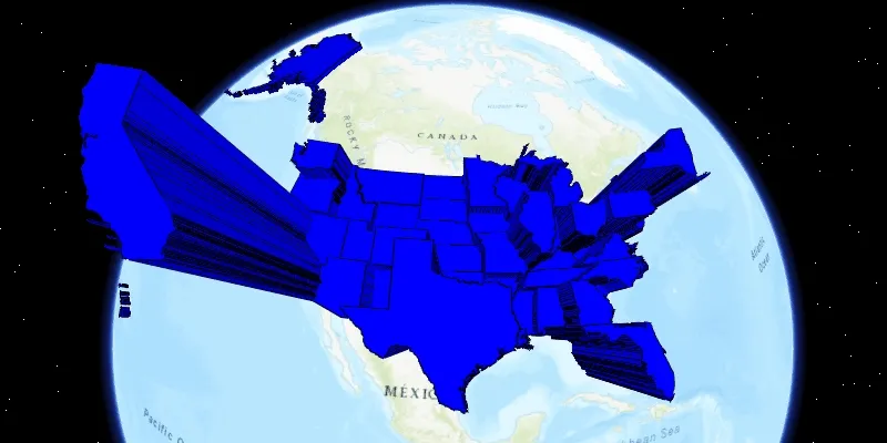
Extrusion is the process of stretching a flat, 2D shape vertically to create a 3D object in a scene. For example, you can extrude building polygons by a height value to create three-dimensional building shapes.
How to use the sample
Press the button to switch between using population density and total population for extrusion. Higher extrusion directly corresponds to higher attribute values.
How it works
- Create a
ServiceFeatureTablefrom a URL. - Create a feature layer from the service feature table.
- Make sure to set the rendering mode to dynamic using
statesFeatureLayer.setRenderingMode(FeatureLayer.RenderingMode.DYNAMIC).
- Make sure to set the rendering mode to dynamic using
- Apply a
SimpleRendererto the feature layer. - Set the extrusion mode of the render using
renderer.getSceneProperties().setExtrusionMode(SceneProperties.ExtrusionMode.ABSOLUTE_HEIGHT). - Set the extrusion expression of the renderer using
renderer.getSceneProperties().setExtrusionExpression(expression).
Relevant API
- ExtrusionExpression
- ExtrusionMode
- FeatureLayer
- FeatureLayer
- SceneProperties
- ServiceFeatureTable
- SimpleRenderer
Tags
3D, extrude, extrusion, extrusion expression, height, renderer, scene
Sample code
FeatureLayerExtrusionSample.java
/* * Copyright 2017 Esri. * * Licensed under the Apache License, Version 2.0 (the "License"); you may not * use this file except in compliance with the License. You may obtain a copy of * the License at * * http://www.apache.org/licenses/LICENSE-2.0 * * Unless required by applicable law or agreed to in writing, software * distributed under the License is distributed on an "AS IS" BASIS, WITHOUT * WARRANTIES OR CONDITIONS OF ANY KIND, either express or implied. See the * License for the specific language governing permissions and limitations under * the License. */
package com.esri.samples.feature_layer_extrusion;
import javafx.application.Application;import javafx.collections.FXCollections;import javafx.geometry.Insets;import javafx.geometry.Pos;import javafx.scene.Scene;import javafx.scene.control.ComboBox;import javafx.scene.control.ListCell;import javafx.scene.layout.StackPane;import javafx.scene.paint.Color;import javafx.stage.Stage;import javafx.util.StringConverter;
import com.esri.arcgisruntime.ArcGISRuntimeEnvironment;import com.esri.arcgisruntime.data.ServiceFeatureTable;import com.esri.arcgisruntime.geometry.Point;import com.esri.arcgisruntime.geometry.SpatialReferences;import com.esri.arcgisruntime.layers.FeatureLayer;import com.esri.arcgisruntime.mapping.ArcGISScene;import com.esri.arcgisruntime.mapping.BasemapStyle;import com.esri.arcgisruntime.mapping.view.Camera;import com.esri.arcgisruntime.mapping.view.SceneView;import com.esri.arcgisruntime.symbology.Renderer;import com.esri.arcgisruntime.symbology.SimpleFillSymbol;import com.esri.arcgisruntime.symbology.SimpleLineSymbol;import com.esri.arcgisruntime.symbology.SimpleRenderer;
public class FeatureLayerExtrusionSample extends Application {
  private SceneView sceneView;
  @Override  public void start(Stage stage) {
    StackPane stackPane = new StackPane();    Scene fxScene = new Scene(stackPane);    // for adding styling to any controls that are added    fxScene.getStylesheets().add(getClass().getResource("/feature_layer_extrusion/style.css").toExternalForm());
    // set title, size, and add scene to stage    stage.setTitle("Feature Layer Extrusion Sample");    stage.setWidth(800);    stage.setHeight(700);    stage.setScene(fxScene);    stage.show();
    // authentication with an API key or named user is required to access basemaps and other location services    String yourAPIKey = System.getProperty("apiKey");    ArcGISRuntimeEnvironment.setApiKey(yourAPIKey);
    // create a scene with a basemap style and set it to the scene view    ArcGISScene scene = new ArcGISScene(BasemapStyle.ARCGIS_TOPOGRAPHIC);    sceneView = new SceneView();    sceneView.setArcGISScene(scene);    stackPane.getChildren().add(sceneView);
    // get us census data as a service feature table    ServiceFeatureTable statesServiceFeatureTable = new ServiceFeatureTable("https://sampleserver6.arcgisonline.com/arcgis/rest/services/Census/MapServer/3");
    // creates feature layer from table and add to scene    final FeatureLayer statesFeatureLayer = new FeatureLayer(statesServiceFeatureTable);    // feature layer must be rendered dynamically for extrusion to work    statesFeatureLayer.setRenderingMode(FeatureLayer.RenderingMode.DYNAMIC);    scene.getOperationalLayers().add(statesFeatureLayer);
    // symbols are used to display features (US states) from table    SimpleLineSymbol lineSymbol = new SimpleLineSymbol(SimpleLineSymbol.Style.SOLID, Color.BLACK, 1.0f);    SimpleFillSymbol fillSymbol = new SimpleFillSymbol(SimpleFillSymbol.Style.SOLID, Color.BLUE, lineSymbol);    final SimpleRenderer renderer = new SimpleRenderer(fillSymbol);    // set the extrusion mode to absolute height    renderer.getSceneProperties().setExtrusionMode(Renderer.SceneProperties.ExtrusionMode.ABSOLUTE_HEIGHT);    statesFeatureLayer.setRenderer(renderer);
    // set camera to focus on state features    Point lookAtPoint = new Point(-10974490, 4814376, 0, SpatialReferences.getWebMercator());    sceneView.setViewpointCamera(new Camera(lookAtPoint, 10000000, 0, 20, 0));
    // create a combo box to choose between different expressions/attributes to extrude by    ComboBox<ExtrusionAttribute> attributeComboBox = new ComboBox<>();    attributeComboBox.setCellFactory(list -> new ListCell<ExtrusionAttribute> (){      @Override      protected void updateItem(ExtrusionAttribute attribute, boolean bln) {
        super.updateItem(attribute, bln);        if (attribute != null) {          setText(attribute.getName());        }      }    });    attributeComboBox.setConverter(new StringConverter<ExtrusionAttribute>() {
      @Override      public String toString(ExtrusionAttribute travelMode) {        return travelMode != null ? travelMode.getName() : "";      }
      @Override      public ExtrusionAttribute fromString(String fileName) {        return null;      }    });    // scale down outlier populations    ExtrusionAttribute populationDensity = new ExtrusionAttribute("Population Density","[POP07_SQMI] * 5000 + 100000");    // scale up density    ExtrusionAttribute totalPopulation = new ExtrusionAttribute("Total Population", "[POP2007]/ 10");    attributeComboBox.setItems(FXCollections.observableArrayList(populationDensity, totalPopulation));    stackPane.getChildren().add(attributeComboBox);    StackPane.setAlignment(attributeComboBox, Pos.TOP_LEFT);    StackPane.setMargin(attributeComboBox, new Insets(10, 0, 0, 10));
    // set the extrusion expression on the renderer when one is chosen in the combo box    attributeComboBox.getSelectionModel().selectedItemProperty().addListener(e -> {      ExtrusionAttribute selectedAttribute = attributeComboBox.getSelectionModel().getSelectedItem();      renderer.getSceneProperties().setExtrusionExpression(selectedAttribute.getExpression());    });
    // start with total population selected    attributeComboBox.getSelectionModel().select(totalPopulation);  }
  /**   * Create a helper class for showing the extrusion attribute name in a ComboBox.   */  private class ExtrusionAttribute {
    private String name;    private String expression;
    public ExtrusionAttribute(String name, String expression) {      this.name = name;      this.expression = expression;    }
    public String getName() {      return name;    }
    public String getExpression() {      return expression;    }  }
  /**   * Stops and releases all resources used in application.   */  @Override  public void stop() {
    if (sceneView != null) {      sceneView.dispose();    }  }
  /**   * Opens and runs application.   *   * @param args arguments passed to this application   */  public static void main(String[] args) {
    Application.launch(args);  }}