Show features from an online feature service.
Use case
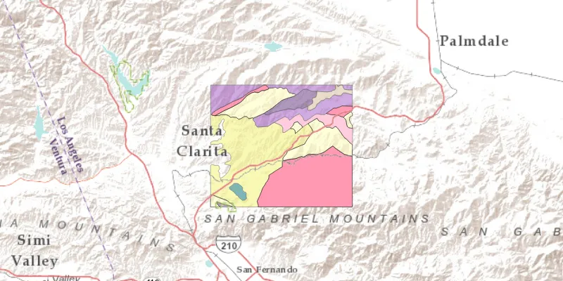
Feature services are useful for sharing vector GIS data with clients so that individual features can be queried, displayed, and edited.
How to use the sample
Run the sample and view the feature service as an operational layer on top of the basemap. Zoom and pan around the map to see the features in greater detail.
How it works
- Create a
ServiceFeatureTablefrom a URL. - Create a feature layer from the service feature table.
- Add the feature layer to your ArcGISMap using
ArcGISMap.getOperationalLayers().add(FeatureLayer).
Relevant API
- ArcGISMap
- FeatureLayer
- MapView
- ServiceFeatureTable
Tags
feature table, layer, layers, service
Sample code
FeatureLayerFeatureServiceSample.java
/* * Copyright 2017 Esri. * * Licensed under the Apache License, Version 2.0 (the "License"); you may not * use this file except in compliance with the License. You may obtain a copy of * the License at * * http://www.apache.org/licenses/LICENSE-2.0 * * Unless required by applicable law or agreed to in writing, software * distributed under the License is distributed on an "AS IS" BASIS, WITHOUT * WARRANTIES OR CONDITIONS OF ANY KIND, either express or implied. See the * License for the specific language governing permissions and limitations under * the License. */
package com.esri.samples.feature_layer_feature_service;
import javafx.application.Application;import javafx.scene.Scene;import javafx.scene.layout.StackPane;import javafx.stage.Stage;
import com.esri.arcgisruntime.ArcGISRuntimeEnvironment;import com.esri.arcgisruntime.data.ServiceFeatureTable;import com.esri.arcgisruntime.geometry.Point;import com.esri.arcgisruntime.geometry.SpatialReferences;import com.esri.arcgisruntime.layers.FeatureLayer;import com.esri.arcgisruntime.mapping.ArcGISMap;import com.esri.arcgisruntime.mapping.BasemapStyle;import com.esri.arcgisruntime.mapping.Viewpoint;import com.esri.arcgisruntime.mapping.view.MapView;
public class FeatureLayerFeatureServiceSample extends Application {
  private MapView mapView;
  private static final String GEOLOGY_FEATURE_SERVICE =      "https://sampleserver6.arcgisonline.com/arcgis/rest/services/Energy/Geology/FeatureServer/9";
  @Override  public void start(Stage stage) {
    try {      // create stack pane and application scene      StackPane stackPane = new StackPane();      Scene scene = new Scene(stackPane);
      // size the stage, add a title, and set scene to stage      stage.setTitle("Feature Layer Feature Service Sample");      stage.setHeight(700);      stage.setWidth(800);      stage.setScene(scene);      stage.show();
      // authentication with an API key or named user is required to access basemaps and other location services      String yourAPIKey = System.getProperty("apiKey");      ArcGISRuntimeEnvironment.setApiKey(yourAPIKey);
      // create a map with the terrain basemap style      ArcGISMap map = new ArcGISMap(BasemapStyle.ARCGIS_TERRAIN);
      // create a map view and set the map to it      mapView = new MapView();      mapView.setMap(map);
      // set a viewpoint on the map view      mapView.setViewpoint(new Viewpoint(new Point(-13176752, 4090404, SpatialReferences.getWebMercator()), 500000));
      // create feature layer with its service feature table      // create the service feature table      ServiceFeatureTable serviceFeatureTable = new ServiceFeatureTable(GEOLOGY_FEATURE_SERVICE);
      // create the feature layer using the service feature table      FeatureLayer featureLayer = new FeatureLayer(serviceFeatureTable);
      // add the feature layer to the map's operational layers      map.getOperationalLayers().add(featureLayer);
      // add the map view to stack pane      stackPane.getChildren().add(mapView);
    } catch (Exception e) {      // on any error, display stack trace      e.printStackTrace();    }  }
  /**   * Stops and releases all resources used in application.   */  @Override  public void stop() {
    // release resources when the application closes    if (mapView != null) {      mapView.dispose();    }  }
  /**   * Opens and runs application.   *   * @param args arguments passed to this application   */  public static void main(String[] args) {
    Application.launch(args);  }}