Display maps and use locators to enable search and routing offline using a mobile map package.
Use case
Mobile map packages make it easy to transmit and store the necessary components for an offline map experience including: transportation networks (for routing/navigation), locators (address search, forward and reverse geocoding), and maps.
A field worker might download a mobile map package to support their operations while working offline, for example to navigate remote oil field roads.
How to use the sample
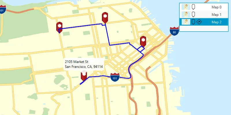
Click the “Open mobile map package” button to bring up a file choosing dialog. Browse to and select a .mmpk file. When chosen, the maps inside the mobile map package will be displayed in a list view. Click on a map in the list to open it.
If the mobile map package has a locator task, the list items will have a pin icon. Click on the map to reverse geocode the clicked locations’s address if a locator task is available.
If the map contains transportation networks, it will have a navigation icon. Click on the map to add locations. If transportation networks are available, a route will be calculated between locations.
How it works
- Create a
MobileMapPackagepassing in the path to the local mmpk file. - Get a list of maps inside the package with
mobileMapPackage.getMaps(). - If the package has a locator, access it with
mobileMapPackage.getLocatorTask(). - To see if a map contains transportation networks, call
map.getTransportationNetworks(). EachTransportationNetworkDatasetcan be used to construct aRouteTask.
Relevant API
- GeocodeResult
- MobileMapPackage
- ReverseGeocodeParameters
- Route
- RouteParameters
- RouteResult
- RouteTask
- TransportationNetworkDataset
Offline data
This sample uses the San Francisco mobile map package and the Yellowstone mobile map package. Both are downloaded from ArcGIS Online automatically.
Tags
disconnected, field mobility, geocode, network, network analysis, offline, routing, search, transportation
Sample code
/* * Copyright 2018 Esri. * * Licensed under the Apache License, Version 2.0 (the "License"); you may not * use this file except in compliance with the License. You may obtain a copy of * the License at * * http://www.apache.org/licenses/LICENSE-2.0 * * Unless required by applicable law or agreed to in writing, software * distributed under the License is distributed on an "AS IS" BASIS, WITHOUT * WARRANTIES OR CONDITIONS OF ANY KIND, either express or implied. See the * License for the specific language governing permissions and limitations under * the License. */
package com.esri.samples.mobile_map_search_and_route;
import java.io.ByteArrayInputStream;import java.io.File;import java.nio.file.Path;import java.util.HashMap;import java.util.List;
import com.esri.arcgisruntime.data.TransportationNetworkDataset;import com.esri.arcgisruntime.geometry.Point;import com.esri.arcgisruntime.loadable.LoadStatus;import com.esri.arcgisruntime.mapping.ArcGISMap;import com.esri.arcgisruntime.mapping.MobileMapPackage;import com.esri.arcgisruntime.mapping.view.Callout;import com.esri.arcgisruntime.mapping.view.Graphic;import com.esri.arcgisruntime.mapping.view.GraphicsOverlay;import com.esri.arcgisruntime.mapping.view.MapView;import com.esri.arcgisruntime.symbology.LineSymbol;import com.esri.arcgisruntime.symbology.PictureMarkerSymbol;import com.esri.arcgisruntime.symbology.SimpleLineSymbol;import com.esri.arcgisruntime.tasks.geocode.GeocodeResult;import com.esri.arcgisruntime.tasks.geocode.ReverseGeocodeParameters;import com.esri.arcgisruntime.tasks.networkanalysis.Route;import com.esri.arcgisruntime.tasks.networkanalysis.RouteTask;import com.esri.arcgisruntime.tasks.networkanalysis.Stop;
import javafx.application.Application;import javafx.geometry.Insets;import javafx.geometry.Point2D;import javafx.geometry.Pos;import javafx.scene.Scene;import javafx.scene.control.Alert;import javafx.scene.control.Button;import javafx.scene.control.ListCell;import javafx.scene.control.ListView;import javafx.scene.image.Image;import javafx.scene.image.ImageView;import javafx.scene.input.MouseButton;import javafx.scene.layout.HBox;import javafx.scene.layout.StackPane;import javafx.scene.paint.Color;import javafx.stage.FileChooser;import javafx.stage.Stage;import javafx.util.Duration;
public class MobileMapSearchAndRouteSample extends Application {
  private MapView mapView;  private MobileMapPackage mobileMapPackage;
  @Override  public void start(Stage stage) {
    try {      // create stack pane and application scene      var stackPane = new StackPane();      var scene = new Scene(stackPane);
      // set title, size, and add scene to stage      stage.setTitle("Mobile Map Search and Route Sample");      stage.setWidth(800);      stage.setHeight(700);      stage.setScene(scene);      stage.show();
      // create a map view      mapView = new MapView();
      // create a list view to list the maps in a mobile map package      ListView<ArcGISMap> mapPackageListView = new ListView<>();      mapPackageListView.setMaxSize(170, 100);
      // create a file chooser to find local mmpk files      var fileChooser = new FileChooser();      FileChooser.ExtensionFilter mmpkFilter = new FileChooser.ExtensionFilter("Map Packages (*.mmpk)", "*.mmpk");      fileChooser.getExtensionFilters().add(mmpkFilter);      fileChooser.setInitialDirectory(new File(System.getProperty("data.dir"), Path.of( "samples-data", "mmpk").toString()));
      // click a button to open the file chooser      Button findMmpkButton = new Button("Open mobile map package");      findMmpkButton.setOnAction(e -> {        File selectedMmpk = fileChooser.showOpenDialog(mapView.getScene().getWindow());        if (selectedMmpk != null) {          // remember the directory of the mmpk for next time          fileChooser.setInitialDirectory(selectedMmpk.getParentFile());          fileChooser.setInitialFileName(selectedMmpk.getAbsolutePath());
          // clear the map and list selection from any previous mmpks          mapPackageListView.getSelectionModel().clearSelection();          mapPackageListView.getItems().clear();          mapView.setMap(null);
          // create a mobile map package from the file path and load it          mobileMapPackage = new MobileMapPackage(selectedMmpk.getAbsolutePath());          mobileMapPackage.loadAsync();          mobileMapPackage.addDoneLoadingListener(() -> {            if (mobileMapPackage.getLoadStatus() == LoadStatus.LOADED && !mobileMapPackage.getMaps().isEmpty()) {              if (!mobileMapPackage.getMaps().isEmpty()) {                // show the maps belonging to the mobile map package in the list view                mobileMapPackage.getMaps().forEach(map -> mapPackageListView.getItems().add(map));                // default to displaying the first map in the map view                mapPackageListView.getSelectionModel().select(mobileMapPackage.getMaps().get(0));              } else {                var alert = new Alert(Alert.AlertType.WARNING, "Map package does not have any maps");                alert.initOwner(mapView.getScene().getWindow());                alert.show();              }            } else {              new Alert(Alert.AlertType.ERROR, "Failed to load the mobile map package").show();            }          });        }      });
      // create a custom list item for each of the map package's maps      mapPackageListView.setCellFactory(list -> new ListCell<>() {        @Override        protected void updateItem(ArcGISMap map, boolean bln) {          super.updateItem(map, bln);          if (map != null) {            var hBox = new HBox();            hBox.setMinWidth(100);
            // show the mobile map package thumbnail image            var thumbnailImageView = new ImageView();            hBox.getChildren().add(thumbnailImageView);            thumbnailImageView.setFitHeight(20);            thumbnailImageView.setPreserveRatio(true);            mobileMapPackage.getItem().fetchThumbnailAsync().toCompletableFuture().whenComplete(              (thumbnailData, exception) -> {                if (exception == null) {                  thumbnailImageView.setImage(new Image(new ByteArrayInputStream(thumbnailData)));                } else {                  exception.printStackTrace();                }              });
            // show a location pin symbol in the list item if the map package includes a locator task            if (mobileMapPackage.getLocatorTask() != null) {              var locatorImageView = new ImageView();              locatorImageView.setFitHeight(20);              locatorImageView.setPreserveRatio(true);              locatorImageView.setImage(new Image(getClass().getResourceAsStream("/pinOutlineSymbol.png")));              hBox.getChildren().add(locatorImageView);            }
            // show a routing symbol in the list item if the map has transportation networks            if (!map.getTransportationNetworks().isEmpty()) {              var routingImageView = new ImageView();              routingImageView.setFitHeight(20);              routingImageView.setPreserveRatio(true);              routingImageView.setImage(new Image(getClass().getResourceAsStream("/routingSymbol.png")));              hBox.getChildren().add(routingImageView);            }            setGraphic(hBox);
            // set the list cell's text to the map's index            setText("Map " + this.getIndex());          } else {            setGraphic(null);            setText(null);          }        }      });
      // create a graphics overlay for showing geocoded locations (for when the mobile map package has a locator task)      var locationsGraphicsOverlay = new GraphicsOverlay();      mapView.getGraphicsOverlays().add(locationsGraphicsOverlay);      var image = new Image(getClass().getResourceAsStream("/pin.png"), 0, 80, true, true);      var pinSymbol = new PictureMarkerSymbol(image);      pinSymbol.loadAsync();
      // create a graphics overlay for showing routes (for when the map has transportation network datasets)      var routesGraphicsOverlay = new GraphicsOverlay();      mapView.getGraphicsOverlays().add(routesGraphicsOverlay);      LineSymbol lineSymbol = new SimpleLineSymbol(SimpleLineSymbol.Style.SOLID, Color.BLUE, 3);
      // switch the map in the map view to the one selected in the list view      mapPackageListView.getSelectionModel().selectedItemProperty().addListener(o -> {        ArcGISMap selectedMap = mapPackageListView.getSelectionModel().getSelectedItem();        if (selectedMap != null) {          mapView.setMap(selectedMap);          // clear any previous locations/routes          locationsGraphicsOverlay.getGraphics().clear();          routesGraphicsOverlay.getGraphics().clear();          mapView.getCallout().setVisible(false);        }      });
      // perform a reverse geocode where the user clicks on the map view if the mobile map package has a locator task      mapView.setOnMouseClicked(e -> {        if (e.isStillSincePress() && e.getButton() == MouseButton.PRIMARY && mobileMapPackage != null && mobileMapPackage.getLocatorTask() != null) {          Point2D point = new Point2D(e.getX(), e.getY());          Point mapPoint = mapView.screenToLocation(point);
          // perform a reverse geocode at the clicked location          var reverseGeocodeParameters = new ReverseGeocodeParameters();          reverseGeocodeParameters.setMaxResults(1);          mobileMapPackage.getLocatorTask().reverseGeocodeAsync(mapPoint, reverseGeocodeParameters).toCompletableFuture()            .whenComplete((geocodeResults, exception) -> {              if (exception == null) {                // show a pin graphic and a callout with the geocode's address                if (!geocodeResults.isEmpty()) {                  // get the geocode from the singleton list of geocode results                  GeocodeResult geocode = geocodeResults.get(0);                  Point location = geocode.getDisplayLocation();
                  // get attributes from the result for the callout                  String address = geocode.getAttributes().get("Match_addr").toString();                  HashMap<String, Object> graphicAttributes = new HashMap<>();                  graphicAttributes.put("title", address.split(",")[0]);                  graphicAttributes.put("detail", address.substring(address.indexOf(", ") + 2));
                  // create a marker for the location                  Graphic marker = new Graphic(geocode.getDisplayLocation(), graphicAttributes, pinSymbol);                  locationsGraphicsOverlay.getGraphics().add(marker);
                  // display the callout at the location                  Callout callout = mapView.getCallout();                  callout.setTitle(marker.getAttributes().get("title").toString());                  callout.setDetail(marker.getAttributes().get("detail").toString());                  callout.setLeaderPosition(Callout.LeaderPosition.BOTTOM);                  callout.showCalloutAt(location, new Point2D(0, -24), Duration.ZERO);
                  // if the map has transportation network datasets, solve for a route between the last two locations                  if (!mapView.getMap().getTransportationNetworks().isEmpty() && locationsGraphicsOverlay.getGraphics().size() > 1) {                    // use the first transportation network dataset in the map to create a route task                    TransportationNetworkDataset networkDataset = mapView.getMap().getTransportationNetworks().get(0);                    var routeTask = new RouteTask(networkDataset);                    // create route parameters with the last two locations' stops                    List<Graphic> locationGraphics = locationsGraphicsOverlay.getGraphics();                    List<Stop> stops = locationGraphics.subList(Math.max(locationGraphics.size() - 2, 0), locationGraphics.size())                      .stream()                      .map(g -> new Stop((Point) g.getGeometry()))                      .toList();                    routeTask.createDefaultParametersAsync().toCompletableFuture()                      .thenCompose(routeParameters -> {                        routeParameters.setStops(stops);                        // solve the route and display the result graphic                        return routeTask.solveRouteAsync(routeParameters).toCompletableFuture();                      }).whenComplete((routeResult, throwable) -> {                        if (throwable == null) {                          Route route = routeResult.getRoutes().get(0);                          Graphic routeGraphic = new Graphic(route.getRouteGeometry(), lineSymbol);                          routesGraphicsOverlay.getGraphics().add(routeGraphic);                        } else {                          var alert = new Alert(Alert.AlertType.WARNING, "No path found between stops");                          alert.initOwner(mapView.getScene().getWindow());                          alert.show();                        }                      });                  }                }              } else {                // show warning if reverse geocode completed with an exception                var alert = new Alert(Alert.AlertType.WARNING, "No address found at this location");                alert.initOwner(mapView.getScene().getWindow());                alert.show();              }            });        }      });
      // add the map view, button, and list view to the stack pane      stackPane.getChildren().addAll(mapView, findMmpkButton, mapPackageListView);      StackPane.setAlignment(findMmpkButton, Pos.TOP_LEFT);      StackPane.setAlignment(mapPackageListView, Pos.TOP_RIGHT);      StackPane.setMargin(findMmpkButton, new Insets(10));      StackPane.setMargin(mapPackageListView, new Insets(10));    } catch (Exception e) {      // on any error, display the stack trace.      e.printStackTrace();    }  }
  /**   * Stops and releases all resources used in application.   */  @Override  public void stop() {
    if (mapView != null) {      mapView.dispose();    }  }
  /**   * Opens and runs application.   *   * @param args arguments passed to this application   */  public static void main(String[] args) {
    Application.launch(args);  }
}