Add rasters and feature tables from a GeoPackage to a map.
Use case
The OGC GeoPackage specification defines an open standard for sharing raster and vector data. You may want to use GeoPackage files to support file-based sharing of geographic data.
How to use the sample
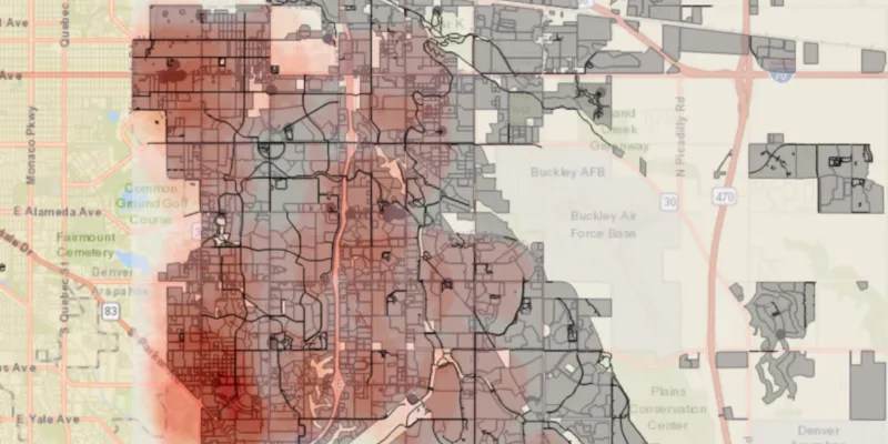
When the sample loads, the feature tables and rasters from the GeoPackage will be shown on the map.
How it works
- Open a
GeoPackagefrom a file. - Iterate through available rasters, exposed by
geopackage.getGeoPackageRasters().- For each raster, create a raster layer using
new Rasterlayer(geopackageRaster), then add it to the map.
- For each raster, create a raster layer using
- Iterate through available feature tables, exposed by
geopackage.getGeoPackageFeatureTables().- For each feature table, create a feature layer using
new FeatureLayer(geopackageFeatureTable), then add it to the map.
- For each feature table, create a feature layer using
Relevant API
- GeoPackage
- GeoPackageFeatureTable
- GeoPackageRaster
About the data
This sample features an Aurora Colorado GeoPackage which holds datasets that cover Aurora, Colorado: Public art (points), Bike trails (lines), Subdivisions (polygons), Airport noise (raster), and liquour license density (raster).
Additional information
GeoPackage uses a single SQLite file (.gpkg) that conforms to the OGC GeoPackage Standard. You can create a GeoPackage file (.gpkg) from your own data using the create a SQLite Database tool in ArcGIS Pro.
Tags
container, geopackage, layer, map, OGC, package, raster, table
Sample code
/* * Copyright 2018 Esri. * * Licensed under the Apache License, Version 2.0 (the "License"); you may not * use this file except in compliance with the License. You may obtain a copy of * the License at * * http://www.apache.org/licenses/LICENSE-2.0 * * Unless required by applicable law or agreed to in writing, software * distributed under the License is distributed on an "AS IS" BASIS, WITHOUT * WARRANTIES OR CONDITIONS OF ANY KIND, either express or implied. See the * License for the specific language governing permissions and limitations under * the License. */
package com.esri.samples.read_geopackage;
import java.io.File;
import javafx.application.Application;import javafx.scene.Scene;import javafx.scene.control.Alert;import javafx.scene.layout.StackPane;import javafx.stage.Stage;
import com.esri.arcgisruntime.ArcGISRuntimeEnvironment;import com.esri.arcgisruntime.data.GeoPackage;import com.esri.arcgisruntime.layers.FeatureLayer;import com.esri.arcgisruntime.layers.RasterLayer;import com.esri.arcgisruntime.loadable.LoadStatus;import com.esri.arcgisruntime.mapping.ArcGISMap;import com.esri.arcgisruntime.mapping.BasemapStyle;import com.esri.arcgisruntime.mapping.Viewpoint;import com.esri.arcgisruntime.mapping.view.MapView;
public class ReadGeoPackageSample extends Application {
  private GeoPackage geoPackage; // keep loadable in scope to avoid garbage collection  private MapView mapView;
  @Override  public void start(Stage stage) {
    try {      // create stack pane and application scene      StackPane stackPane = new StackPane();      Scene scene = new Scene(stackPane);
      // set title, size, and add scene to stage      stage.setTitle("Read GeoPackage Sample");      stage.setWidth(800);      stage.setHeight(700);      stage.setScene(scene);      stage.show();
      // authentication with an API key or named user is required to access basemaps and other location services      String yourAPIKey = System.getProperty("apiKey");      ArcGISRuntimeEnvironment.setApiKey(yourAPIKey);
      // create a map with the streets basemap style      final ArcGISMap map = new ArcGISMap(BasemapStyle.ARCGIS_STREETS);
      // create a map view and set the map to it      mapView = new MapView();      mapView.setMap(map);
      // set a viewpoint on the map view      mapView.setViewpoint(new Viewpoint(39.7294, -104.8319, 288895));
      // load the local GeoPackage      File geoPackageFile = new File(System.getProperty("data.dir"), "./samples-data/auroraCO/AuroraCO.gpkg");      geoPackage = new GeoPackage(geoPackageFile.getAbsolutePath());      geoPackage.loadAsync();      geoPackage.addDoneLoadingListener(() -> {        if (geoPackage.getLoadStatus() == LoadStatus.LOADED) {          // add raster layers from the rasters in the GeoPackage          geoPackage.getGeoPackageRasters().forEach(raster -> {            RasterLayer rasterLayer = new RasterLayer(raster);            // make the layer semi-transparent to see through it            rasterLayer.setOpacity(0.5f);
            map.getOperationalLayers().add(rasterLayer);          });
          // add feature layers from the feature tables in the GeoPackage          geoPackage.getGeoPackageFeatureTables().forEach(table -> {            FeatureLayer featureLayer = new FeatureLayer(table);
            map.getOperationalLayers().add(featureLayer);          });        } else {          new Alert(Alert.AlertType.ERROR, "GeoPackage failed to load").show();        }      });
      // add the map view to the stack pane      stackPane.getChildren().add(mapView);
    } catch (Exception e) {      // on any error, display the stack trace      e.printStackTrace();    }  }
  /**   * Stops and releases all resources used in application.   */  @Override  public void stop() {
    if (mapView != null) {      mapView.dispose();    }  }
  /**   * Opens and runs application.   *   * @param args arguments passed to this application   */  public static void main(String[] args) {
    Application.launch(args);  }
}