What is a global data search?
You can retrieve global demographic data, also known as standard demographics, for 170 countries and regions. The data include population, income, age, households, education, spending, jobs, marital status, and key facts.
How to access the data
To get standard demographic data using the enrich operation, you use the Key data collection. This is provided for you by default if you do not provide a data collection for the enrich operation.
The Key data collection contains the following data variables, which will populated when you run the request:
| Data variable | Description | Examples |
|---|---|---|
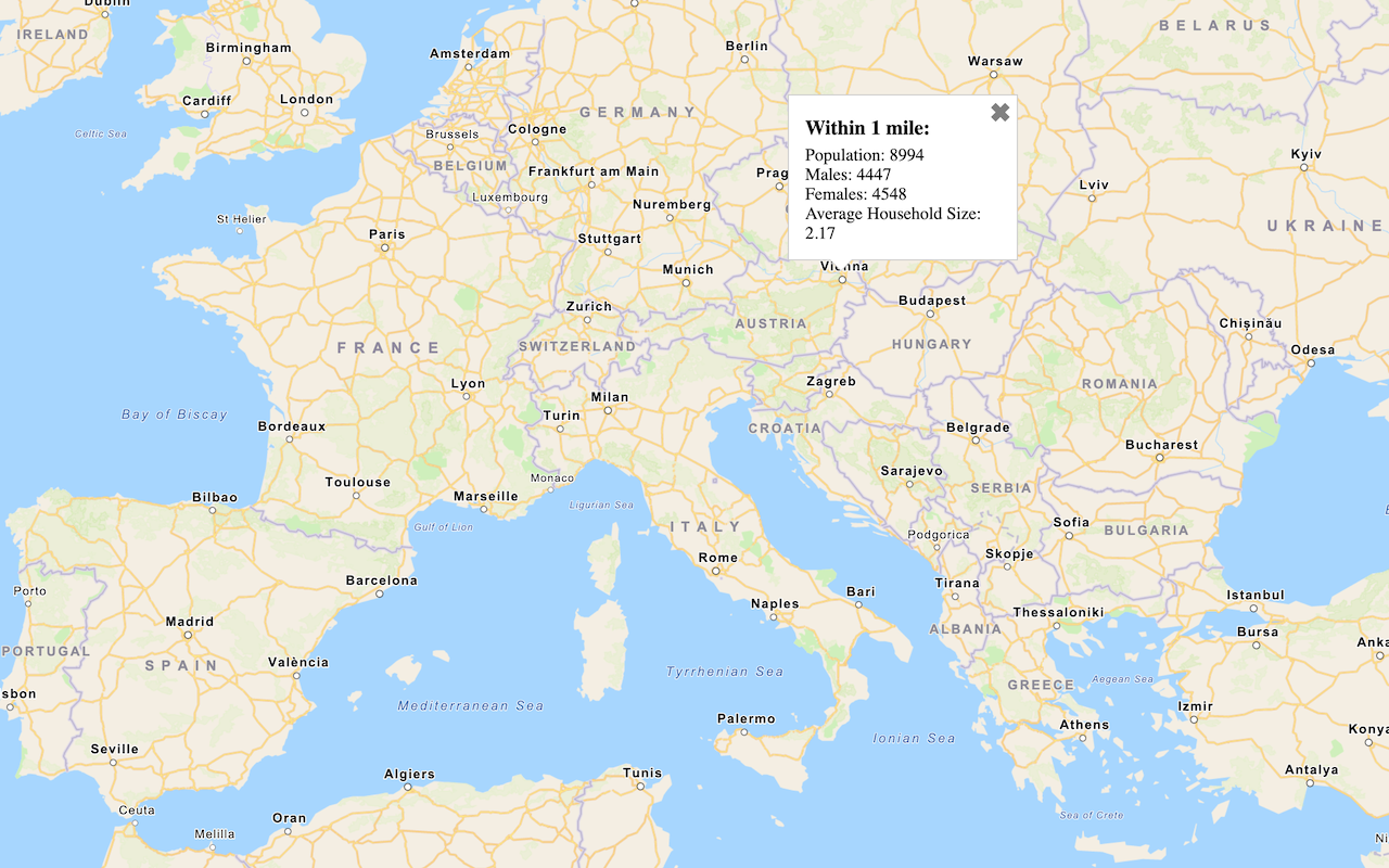
TOTPOP | Total population | 619 |
TOTHH | Total households | 354 |
AVGHHSZ | Average household size | 1.75 |
MALES | Total male population | 292 |
FEMALES | Total female population | 328 |
URL request
Learn more about standard and enhanced endpoints in Service endpoints.
https://geoenrich.arcgis.com/arcgis/rest/services/World/geoenrichmentserver/Geoenrichment/enrich?<parameters>Required parameters
| Name | Description | Examples |
|---|---|---|
f | The format of the data returned. | f=json f=pjson f=geojson f=csv |
token | An API key or OAuth 2.0 access token. Learn how to get an access token in Security and authentication. | token=< token=< |
study | The input point, address, line, polygon or administrative boundary | studystudystudy |
Key parameters
| Name | Description | Examples |
|---|---|---|
analysis | Returns a subset of attributes from one or more data collections. | ["food.X1131_ |
data | Returns a preassembled list of analysis variables curated for specific countries and regions. | [educationalattainment] |
return | Retrieves the study area's geometry for display on a map. | true, false |
Additional parameters:
The add returns percent, average and index attributes. The intersecting parameter returns information about administrative boundaries intersected by an input point. The use parameter provides a performance hint to the service when all input study areas lie within the same country or region.
Code examples
Find global facts (1 mile buffer)
Use the GeoEnrichment service to enrich a 1 mile ring buffer using the only required parameter, study. With the search box, select a pre-defined location or click on the map to submit a point and create a 1 mile ring buffer. Facts are returned from the default data collection, Key Global Facts. Key Global facts contains five analysis variables that are tabulated for all countries and regions.
Steps
-
Reference the service.
-
Define
studyto submit a point.Areas -
Set the API key.
APIs
function getDemographicData(point) {
// Request demographic data
arcgisRest.queryDemographicData({
studyAreas: [{ "geometry": { "x": point.longitude, "y": point.latitude } }],
authentication: authentication
})
.then((response) => {
if (response.results[0].value.FeatureSet.length > 0 &&
response.results[0].value.FeatureSet[0].features.length > 0) {
const attributes = response.results[0].value.FeatureSet[0].features[0].attributes;
showData(attributes, point);
} else {
console.log("No data found.");
}
});
}
REST API
curl https://geoenrich.arcgis.com/arcgis/rest/services/World/geoenrichmentserver/Geoenrichment/enrich? \
-d "studyAreas=[{'geometry':{'x': -117.1956, 'y': 34.0572}}]"
-d "f=json"
-d "token=<ACCESS_TOKEN>"{
"results" : [ {
"paramName" : "GeoEnrichmentResult",
"dataType" : "GeoEnrichmentResult",
"value" : {
"version" : "2.0",
"FeatureSet" : [ {
"displayFieldName" : "",
"fieldAliases" : {
"ID" : "Id",
"OBJECTID" : "Object ID",
"sourceCountry" : "Country code",
"areaType" : "Area type",
Tutorials
Query demographic data
Query demographic information for locations around the world with the GeoEnrichment service.

Enrich data sources
Enrich data with demographic information and local business facts using the spatial analysis service.
Find data using analysis variables
Learn how to use the Analysis Variable Finder to get enrichment data.
Find data using data collections
Learn how to use the Data Collection Finder to get enrichment data.
Services
GeoEnrichment service
Find facts and demographic information about a location or area.
API support
- 1. Access via ArcGIS REST JS or use a task.
- 2. Access via HTTP request.
- 3. Access via HTTP request and authentication.
- 4. Access via ArcGIS REST JS.