Display coordinate system grids including Latitude/Longitude, MGRS, UTM and USNG on a map view. Also, toggle label visibility and change the color of grid lines and grid labels.
Use case
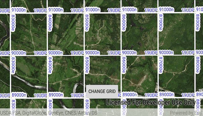
Grids are often used on printed maps, but can also be helpful on digital maps, to identify locations on a map.
How to use the sample
Tap on the 'Change Grid' button to open a settings view. You can select type of grid from 'Grid Type' (LatLong, MGRS, UTM and USNG) and modify its properties like label visibility, grid line color, and grid label color.
How it works
- Create an instance of one of the
Gridtypes. - Grid lines and labels can be styled per grid level with
setLineSymbol(gridLevel, lineSymbol)andsetTextSymbol(gridLevel, textSymbol)methods on the grid. - The label position can be set with
setLabelPosition(labelPosition)method on the grid. - For the
LatitudeLongitudeGridtype, you can specify a label format ofDECIMAL_DEGREESorDEGREES_MINUTES_SECONDS. - To set the grid, use the
setGrid(grid)method on the map view.
Relevant API
- Grid
- LatitudeLongitudeGrid
- MapView
- MgrsGrid
- SimpleLineSymbol
- TextSymbol
- UsngGrid
- UtmGrid
Tags
coordinates, degrees, graticule, grid, latitude, longitude, MGRS, minutes, seconds, USNG, UTM
Sample Code
MainActivity.java
/* Copyright 2018 Esri
*
* Licensed under the Apache License, Version 2.0 (the "License");
* you may not use this file except in compliance with the License.
* You may obtain a copy of the License at
*
* http://www.apache.org/licenses/LICENSE-2.0
*
* Unless required by applicable law or agreed to in writing, software
* distributed under the License is distributed on an "AS IS" BASIS,
* WITHOUT WARRANTIES OR CONDITIONS OF ANY KIND, either express or implied.
* See the License for the specific language governing permissions and
* limitations under the License.
*
*/
package com.esri.arcgisruntime.sample.displaygrid;
import android.graphics.Color;
import android.os.Bundle;
import android.view.View;
import android.widget.AdapterView;
import android.widget.ArrayAdapter;
import android.widget.Button;
import android.widget.CheckBox;
import android.widget.Spinner;
import android.widget.Toast;
import androidx.appcompat.app.AlertDialog;
import androidx.appcompat.app.AppCompatActivity;
import com.esri.arcgisruntime.ArcGISRuntimeEnvironment;
import com.esri.arcgisruntime.geometry.Point;
import com.esri.arcgisruntime.geometry.SpatialReference;
import com.esri.arcgisruntime.mapping.ArcGISMap;
import com.esri.arcgisruntime.mapping.BasemapStyle;
import com.esri.arcgisruntime.mapping.Viewpoint;
import com.esri.arcgisruntime.mapping.view.Grid;
import com.esri.arcgisruntime.mapping.view.LatitudeLongitudeGrid;
import com.esri.arcgisruntime.mapping.view.MapView;
import com.esri.arcgisruntime.mapping.view.MgrsGrid;
import com.esri.arcgisruntime.mapping.view.UsngGrid;
import com.esri.arcgisruntime.mapping.view.UtmGrid;
import com.esri.arcgisruntime.symbology.LineSymbol;
import com.esri.arcgisruntime.symbology.SimpleLineSymbol;
import com.esri.arcgisruntime.symbology.TextSymbol;
public class MainActivity extends AppCompatActivity {
private MapView mMapView;
private CheckBox mLabelsCheckBox;
private int mLineColor;
private int mLabelColor;
@Override
protected void onCreate(Bundle savedInstanceState) {
super.onCreate(savedInstanceState);
setContentView(R.layout.activity_main);
// authentication with an API key or named user is required to access basemaps and other
// location services
ArcGISRuntimeEnvironment.setApiKey(BuildConfig.API_KEY);
// inflate views from activity_main
mMapView = findViewById(R.id.mapView);
Button mMenuButton = findViewById(R.id.menu_button);
// set up a popup menu to manage grid settings
final AlertDialog.Builder builder = new AlertDialog.Builder(this);
final View view = getLayoutInflater().inflate(R.layout.popup_menu, null);
builder.setView(view);
final AlertDialog dialog = builder.create();
// inflate views from popup_menu
Spinner mGridSpinner = view.findViewById(R.id.layer_spinner);
mLabelsCheckBox = view.findViewById(R.id.labels_checkBox);
Spinner mColorsSpinner = view.findViewById(R.id.line_color_spinner);
Spinner mLabelColorSpinner = view.findViewById(R.id.label_color_spinner);
// create drop-down list of different grids
ArrayAdapter<String> adapter = new ArrayAdapter<>(this, android.R.layout.simple_spinner_item,
getResources().getStringArray(R.array.layers_array));
adapter.setDropDownViewResource(android.R.layout.simple_spinner_dropdown_item);
mGridSpinner.setAdapter(adapter);
// create drop-down list of different colors
ArrayAdapter<String> colorAdapter = new ArrayAdapter<>(this, android.R.layout.simple_spinner_item,
getResources().getStringArray(R.array.colors_array));
colorAdapter.setDropDownViewResource(android.R.layout.simple_spinner_dropdown_item);
mColorsSpinner.setAdapter(colorAdapter);
// create drop-down list of different label colors
ArrayAdapter<String> labelColorAdapter = new ArrayAdapter<>(this, android.R.layout.simple_spinner_item,
getResources().getStringArray(R.array.colors_array));
labelColorAdapter.setDropDownViewResource(android.R.layout.simple_spinner_dropdown_item);
mLabelColorSpinner.setAdapter(labelColorAdapter);
// create a map with imagery basemap
ArcGISMap map = new ArcGISMap(BasemapStyle.ARCGIS_IMAGERY);
// set the map to be displayed in this view
mMapView.setMap(map);
// set viewpoint
final Point center = new Point(-7702852.905619, 6217972.345771, 23227, SpatialReference.create(3857));
mMapView.setViewpoint(new Viewpoint(center, 23227));
// set defaults on grid
mMapView.setGrid(new LatitudeLongitudeGrid());
mLabelsCheckBox.setChecked(true);
// change different grids on the Map View
mGridSpinner.setOnItemSelectedListener(new AdapterView.OnItemSelectedListener() {
@Override public void onItemSelected(AdapterView<?> parent, View view, int position, long id) {
// set the grid type
switch (position) {
case 0:
mMapView.setGrid(new LatitudeLongitudeGrid());
mMapView.setViewpointScaleAsync(23227);
break;
case 1:
mMapView.setGrid(new MgrsGrid());
mMapView.setViewpointScaleAsync(23227);
break;
case 2:
mMapView.setGrid(new UtmGrid());
mMapView.setViewpointScaleAsync(10000000);
break;
case 3:
mMapView.setGrid(new UsngGrid());
mMapView.setViewpointScaleAsync(23227);
break;
default:
Toast.makeText(MainActivity.this,"Unsupported option", Toast.LENGTH_SHORT).show();
break;
}
// make sure settings persist on grid type change
setLabelVisibility();
changeGridColor(mLineColor);
changeLabelColor(mLabelColor);
}
@Override public void onNothingSelected(AdapterView<?> parent) {
}
});
// change grid lines color
mColorsSpinner.setOnItemSelectedListener(new AdapterView.OnItemSelectedListener() {
@Override public void onItemSelected(AdapterView<?> parent, View view, int position, long id) {
//set the color
switch (position) {
case 0:
mLineColor = Color.RED;
break;
case 1:
mLineColor = Color.WHITE;
break;
case 2:
mLineColor = Color.BLUE;
break;
default:
Toast.makeText(MainActivity.this,"Unsupported option", Toast.LENGTH_SHORT).show();
break;
}
changeGridColor(mLineColor);
}
@Override public void onNothingSelected(AdapterView<?> parent) {
}
});
// change grid labels color
mLabelColorSpinner.setOnItemSelectedListener(new AdapterView.OnItemSelectedListener() {
@Override public void onItemSelected(AdapterView<?> parent, View view, int position, long id) {
// set the color
switch (position) {
case 0:
mLabelColor = Color.RED;
break;
case 1:
mLabelColor = Color.WHITE;
break;
case 2:
mLabelColor = Color.BLUE;
break;
default:
Toast.makeText(MainActivity.this,"Unsupported option", Toast.LENGTH_SHORT).show();
break;
}
changeLabelColor(mLabelColor);
}
@Override public void onNothingSelected(AdapterView<?> parent) {
}
});
// hide and show label visibility when the checkbox is clicked
mLabelsCheckBox.setOnClickListener(v -> setLabelVisibility());
// display pop-up box when button is clicked
mMenuButton.setOnClickListener(v -> dialog.show());
}
private void setLabelVisibility() {
mMapView.getGrid().setLabelVisible(mLabelsCheckBox.isChecked());
}
private void changeGridColor(int color) {
Grid grid = mMapView.getGrid();
int gridLevels = grid.getLevelCount();
for (int gridLevel = 0; gridLevel <= gridLevels - 1; gridLevel++) {
LineSymbol lineSymbol = new SimpleLineSymbol(SimpleLineSymbol.Style.SOLID, color, gridLevel + 1);
grid.setLineSymbol(gridLevel, lineSymbol);
}
}
private void changeLabelColor(int color) {
Grid grid = mMapView.getGrid();
int gridLevels = grid.getLevelCount();
for (int gridLevel = 0; gridLevel <= gridLevels - 1; gridLevel++) {
TextSymbol textSymbol = new TextSymbol();
textSymbol.setColor(color);
textSymbol.setSize(14);
textSymbol.setHorizontalAlignment(TextSymbol.HorizontalAlignment.LEFT);
textSymbol.setVerticalAlignment(TextSymbol.VerticalAlignment.BOTTOM);
textSymbol.setHaloColor(Color.WHITE);
textSymbol.setHaloWidth(gridLevel + 1);
grid.setTextSymbol(gridLevel, textSymbol);
}
}
@Override
protected void onPause() {
super.onPause();
mMapView.pause();
}
@Override
protected void onResume() {
super.onResume();
mMapView.resume();
}
@Override
protected void onDestroy() {
super.onDestroy();
mMapView.dispose();
}
}