Cut a geometry along a polyline.
Use case
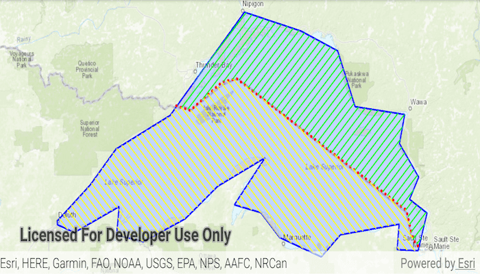
You might cut a polygon representing a large parcel to subdivide it into smaller parcels.
How to use the sample
Tap the "Cut" button to cut the polygon with the polyline and see the resulting parts (shaded in different colors).
How it works
- Pass the geometry and polyline to
GeometryEngine.cutto cut the geometry along the polyline. - Loop through the returned list of part geometries. Some of these geometries may be multi-part.
Relevant API
- GeometryEngine
- Polygon
- Polyline
Tags
cut, geometry, split
Sample Code
MainActivity.java
/* Copyright 2018 Esri
*
* Licensed under the Apache License, Version 2.0 (the "License");
* you may not use this file except in compliance with the License.
* You may obtain a copy of the License at
*
* http://www.apache.org/licenses/LICENSE-2.0
*
* Unless required by applicable law or agreed to in writing, software
* distributed under the License is distributed on an "AS IS" BASIS,
* WITHOUT WARRANTIES OR CONDITIONS OF ANY KIND, either express or implied.
* See the License for the specific language governing permissions and
* limitations under the License.
*
*/
package com.esri.arcgisruntime.sample.cutgeometry;
import java.util.Arrays;
import java.util.List;
import android.os.Bundle;
import android.widget.Button;
import androidx.appcompat.app.AppCompatActivity;
import com.esri.arcgisruntime.ArcGISRuntimeEnvironment;
import com.esri.arcgisruntime.geometry.Geometry;
import com.esri.arcgisruntime.geometry.GeometryEngine;
import com.esri.arcgisruntime.geometry.Point;
import com.esri.arcgisruntime.geometry.PointCollection;
import com.esri.arcgisruntime.geometry.Polygon;
import com.esri.arcgisruntime.geometry.Polyline;
import com.esri.arcgisruntime.geometry.SpatialReferences;
import com.esri.arcgisruntime.mapping.ArcGISMap;
import com.esri.arcgisruntime.mapping.BasemapStyle;
import com.esri.arcgisruntime.mapping.view.Graphic;
import com.esri.arcgisruntime.mapping.view.GraphicsOverlay;
import com.esri.arcgisruntime.mapping.view.MapView;
import com.esri.arcgisruntime.symbology.SimpleFillSymbol;
import com.esri.arcgisruntime.symbology.SimpleLineSymbol;
public class MainActivity extends AppCompatActivity {
private MapView mMapView;
@Override
protected void onCreate(Bundle savedInstanceState) {
super.onCreate(savedInstanceState);
setContentView(R.layout.activity_main);
// authentication with an API key or named user is required to access basemaps and other
// location services
ArcGISRuntimeEnvironment.setApiKey(BuildConfig.API_KEY);
// inflate views from layout
mMapView = findViewById(R.id.mapView);
Button cutButton = findViewById(R.id.cutButton);
// create a map with the Basemap Style topographic
ArcGISMap map = new ArcGISMap(BasemapStyle.ARCGIS_TOPOGRAPHIC);
// set the map to be displayed in this view
mMapView.setMap(map);
// create a graphic overlay
final GraphicsOverlay graphicsOverlay = new GraphicsOverlay();
mMapView.getGraphicsOverlays().add(graphicsOverlay);
// create a blue polygon graphic to cut
final Graphic polygonGraphic = new Graphic(createLakeSuperiorPolygon(),
new SimpleFillSymbol(SimpleFillSymbol.Style.SOLID,0x220000FF,
new SimpleLineSymbol(SimpleLineSymbol.Style.SOLID, 0xFF0000FF, 2)));
graphicsOverlay.getGraphics().add(polygonGraphic);
// create a red polyline graphic to cut the polygon
final Graphic polylineGraphic = new Graphic(createBorder(), new SimpleLineSymbol(SimpleLineSymbol.Style.DOT,
0xFFFF0000, 3));
graphicsOverlay.getGraphics().add(polylineGraphic);
// zoom to show the polygon graphic
mMapView.setViewpointGeometryAsync(polygonGraphic.getGeometry());
// create a button to perform the cut operation
cutButton.setOnClickListener(v -> {
List<Geometry> parts = GeometryEngine
.cut(polygonGraphic.getGeometry(), (Polyline) polylineGraphic.getGeometry());
// create graphics for the US and Canada sides
Graphic canadaSide = new Graphic(parts.get(0), new SimpleFillSymbol(SimpleFillSymbol.Style.BACKWARD_DIAGONAL,
0xFF00FF00, new SimpleLineSymbol(SimpleLineSymbol.Style.NULL, 0xFFFFFFFF, 0)));
Graphic usSide = new Graphic(parts.get(1), new SimpleFillSymbol(SimpleFillSymbol.Style.FORWARD_DIAGONAL,
0xFFFFFF00, new SimpleLineSymbol(SimpleLineSymbol.Style.NULL, 0xFFFFFFFF, 0)));
graphicsOverlay.getGraphics().addAll(Arrays.asList(canadaSide, usSide));
cutButton.setEnabled(false);
});
}
/**
* Creates a polyline along the US/Canada border over Lake Superior.
*
* @return polyline
*/
private static Polyline createBorder() {
PointCollection points = new PointCollection(SpatialReferences.getWebMercator());
points.add(new Point(-9981328.687124, 6111053.281447));
points.add(new Point(-9946518.044066, 6102350.620682));
points.add(new Point(-9872545.427566, 6152390.920079));
points.add(new Point(-9838822.617103, 6157830.083057));
points.add(new Point(-9446115.050097, 5927209.572793));
points.add(new Point(-9430885.393759, 5876081.440801));
points.add(new Point(-9415655.737420, 5860851.784463));
return new Polyline(points);
}
/**
* Creates a polygon of points around Lake Superior.
*
* @return polygon
*/
private static Polygon createLakeSuperiorPolygon() {
PointCollection points = new PointCollection(SpatialReferences.getWebMercator());
points.add(new Point(-10254374.668616, 5908345.076380));
points.add(new Point(-10178382.525314, 5971402.386779));
points.add(new Point(-10118558.923141, 6034459.697178));
points.add(new Point(-9993252.729399, 6093474.872295));
points.add(new Point(-9882498.222673, 6209888.368416));
points.add(new Point(-9821057.766387, 6274562.532928));
points.add(new Point(-9690092.583250, 6241417.023616));
points.add(new Point(-9605207.742329, 6206654.660191));
points.add(new Point(-9564786.389509, 6108834.986367));
points.add(new Point(-9449989.747500, 6095091.726408));
points.add(new Point(-9462116.153346, 6044160.821855));
points.add(new Point(-9417652.665244, 5985145.646738));
points.add(new Point(-9438671.768711, 5946341.148031));
points.add(new Point(-9398250.415891, 5922088.336339));
points.add(new Point(-9419269.519357, 5855797.317714));
points.add(new Point(-9467775.142741, 5858222.598884));
points.add(new Point(-9462924.580403, 5902686.086985));
points.add(new Point(-9598740.325877, 5884092.264688));
points.add(new Point(-9643203.813979, 5845287.765981));
points.add(new Point(-9739406.633691, 5879241.702350));
points.add(new Point(-9783061.694736, 5922896.763395));
points.add(new Point(-9844502.151022, 5936640.023354));
points.add(new Point(-9773360.570059, 6019099.583107));
points.add(new Point(-9883306.649729, 5968977.105610));
points.add(new Point(-9957681.938918, 5912387.211662));
points.add(new Point(-10055501.612742, 5871965.858842));
points.add(new Point(-10116942.069028, 5884092.264688));
points.add(new Point(-10111283.079633, 5933406.315128));
points.add(new Point(-10214761.742852, 5888134.399970));
points.add(new Point(-10254374.668616, 5901877.659929));
return new Polygon(points);
}
@Override
protected void onPause() {
super.onPause();
mMapView.pause();
}
@Override
protected void onResume() {
super.onResume();
mMapView.resume();
}
@Override
protected void onDestroy() {
super.onDestroy();
mMapView.dispose();
}
}