Set the map's reference scale and which feature layers should honor the reference scale.
Use case
Setting a reference scale on an ArcGISMap fixes the size of symbols and text to the desired height and width at that scale. As you zoom in and out, symbols and text will increase or decrease in size accordingly. When no reference scale is set, symbol and text sizes remain the same size relative to the MapView.
Map annotations are typically only relevant at certain scales. For instance, annotations to a map showing a construction site are only relevant at that construction site's scale. So, when the map is zoomed out that information shouldn't scale with the MapView, but should instead remain scaled with the ArcGISMap.
How to use the sample
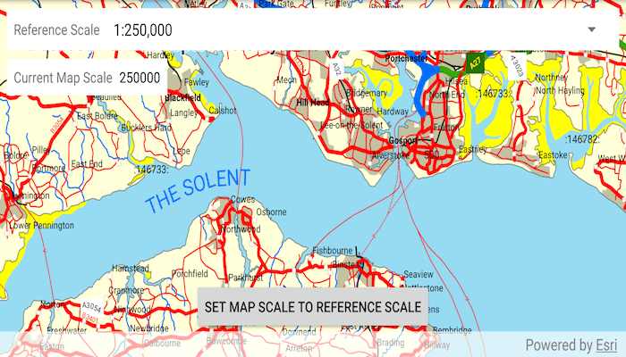
- Use the drop down at the top to set the map's reference scale (1:500,000 1:250,000 1:100,000 1:50,000).
- Tap the button to set the map scale to the reference scale.
- Use the checkboxes in the overflow menu to set which feature layers should honor the reference scale.
How it works
- Get and set the reference scale property on the
ArcGISMapobject. - If checked, get and set the scale symbols property on each individual
FeatureLayerobject.
Relevant API
- ArcGISMap
- FeatureLayer
Additional information
The map reference scale should normally be set by the map's author and not exposed to the end user like it is in this sample.
Tags
map, reference scale, scene
Sample Code
/* Copyright 2019 Esri
*
* Licensed under the Apache License, Version 2.0 (the "License");
* you may not use this file except in compliance with the License.
* You may obtain a copy of the License at
*
* http://www.apache.org/licenses/LICENSE-2.0
*
* Unless required by applicable law or agreed to in writing, software
* distributed under the License is distributed on an "AS IS" BASIS,
* WITHOUT WARRANTIES OR CONDITIONS OF ANY KIND, either express or implied.
* See the License for the specific language governing permissions and
* limitations under the License.
*
*/
package com.esri.arcgisruntime.mapreferencescale;
import android.os.Bundle;
import androidx.appcompat.app.AppCompatActivity;
import android.view.Menu;
import android.view.MenuItem;
import android.view.View;
import android.widget.AdapterView;
import android.widget.Button;
import android.widget.Spinner;
import android.widget.TextView;
import com.esri.arcgisruntime.layers.FeatureLayer;
import com.esri.arcgisruntime.mapping.ArcGISMap;
import com.esri.arcgisruntime.mapping.LayerList;
import com.esri.arcgisruntime.mapping.Viewpoint;
import com.esri.arcgisruntime.mapping.view.MapView;
import com.esri.arcgisruntime.portal.Portal;
import com.esri.arcgisruntime.portal.PortalItem;
public class MainActivity extends AppCompatActivity {
private MapView mMapView;
private LayerList mOperationalLayers;
@Override
protected void onCreate(Bundle savedInstanceState) {
super.onCreate(savedInstanceState);
setContentView(R.layout.activity_main);
// get web map as an ArcGISMap
Portal portal = new Portal(getString(R.string.runtime_portal_url));
PortalItem portalItem = new PortalItem(portal, getString(R.string.isle_of_wight_portal_item));
ArcGISMap map = new ArcGISMap(portalItem);
// get a reference to the map view and set the map to it
mMapView = findViewById(R.id.mapView);
mMapView.setMap(map);
// get a reference to the spinner
Spinner referenceScaleSpinner = findViewById(R.id.reference_scale_spinner);
referenceScaleSpinner.setOnItemSelectedListener(new AdapterView.OnItemSelectedListener() {
@Override public void onItemSelected(AdapterView<?> adapterView, View view, int position, long l) {
// get the reference scale from the spinner in the format "1:25,000"
String referenceScaleString = String.valueOf(adapterView.getItemAtPosition(position));
// use regex to get just the reference scale number as a string
referenceScaleString = referenceScaleString.substring(referenceScaleString.indexOf(':') + 1)
.replaceAll(",", "");
// set the reference scale with the double value of the reference scale string
setReferenceScale(Double.valueOf(referenceScaleString));
}
@Override public void onNothingSelected(AdapterView<?> adapterView) {
}
});
// set initial selection to the 3rd option, 1:250,000
referenceScaleSpinner.setSelection(2);
// update map scale indicator on map scale change
TextView mapScale = findViewById(R.id.currMapScaleTextView);
mMapView.addMapScaleChangedListener(
mapScaleChangedEvent -> mapScale.setText(String.valueOf(Math.round(mMapView.getMapScale()))));
// use the current viewpoint's center and the current reference scale to set a new viewpoint
Button matchScalesButton = findViewById(R.id.matchScalesButton);
matchScalesButton.setOnClickListener(view -> mMapView.setViewpointAsync(new Viewpoint(
mMapView.getCurrentViewpoint(Viewpoint.Type.CENTER_AND_SCALE).getTargetGeometry().getExtent().getCenter(),
mMapView.getMap().getReferenceScale()), 1));
}
/**
* Set and get the map's reference scale.
*
* @param referenceScale as a double
*/
private void setReferenceScale(double referenceScale) {
mMapView.getMap().setReferenceScale(referenceScale);
}
/**
* Set and get scale symbols for the given feature layer.
*
* @param featureLayer that should honor scale symbols or not
* @param isScaleSymbols true to honor reference scale, false to ignore reference scale
*/
private void setScaleSymbol(FeatureLayer featureLayer, boolean isScaleSymbols) {
featureLayer.setScaleSymbols(isScaleSymbols);
}
@Override public boolean onCreateOptionsMenu(Menu menu) {
// once the map is loaded
mMapView.getMap().addDoneLoadingListener(() -> {
// get the map's operational layer list
mOperationalLayers = mMapView.getMap().getOperationalLayers();
// add each of those layers to the menu and set them to checked
for (int i = 0; i < mOperationalLayers.size(); i++) {
menu.add(Menu.NONE, i, Menu.NONE, mOperationalLayers.get(i).getName());
menu.getItem(i).setCheckable(true);
menu.getItem(i).setChecked(true);
}
});
return super.onCreateOptionsMenu(menu);
}
@Override public boolean onOptionsItemSelected(MenuItem item) {
// toggle the checkbox of the menu item
item.setChecked(!item.isChecked());
// set the feature layer to honor the reference scale, or not
setScaleSymbol((FeatureLayer) mOperationalLayers.get(item.getItemId()), item.isChecked());
return super.onOptionsItemSelected(item);
}
@Override
protected void onPause() {
mMapView.pause();
super.onPause();
}
@Override
protected void onResume() {
super.onResume();
mMapView.resume();
}
@Override
protected void onDestroy() {
mMapView.dispose();
super.onDestroy();
}
}