Display a WMS layer using a WMS service URL.
Use case
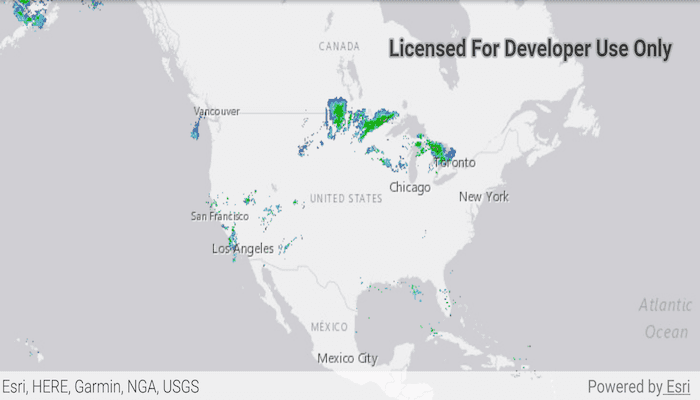
WMS is an OGC standard for displaying maps from images that are dynamically-generated on a web server. WMS is particularly useful for data that changes frequently, contains cartographically complex detail, or requires an open source data standard.
How to use the sample
The map will load automatically when the sample starts.
How it works
- Create a
WmsLayerspecifying the URL of the service and the names of layers you want to display.- Note: The name comes from the
Nameproperty, not theTitleproperty. On many services, the title is human-readable while the name is a numeric identifier.
- Note: The name comes from the
- Add the layer to the map as an operational layer with
map.getOperationalLayers().add(wmsLayer).
About the data
This sample uses a U.S. National Weather Service radar map. Because WMS services generate map images on-the-fly, this layer is always up-to-date with the latest NOAA NEXRAD radar observations.
Relevant API
- ArcGISMap
- MapView
- WmsLayer
Tags
OGC, web map service, WMS
Sample Code
MainActivity.java
/* Copyright 2017 Esri
*
* Licensed under the Apache License, Version 2.0 (the "License");
* you may not use this file except in compliance with the License.
* You may obtain a copy of the License at
*
* http://www.apache.org/licenses/LICENSE-2.0
*
* Unless required by applicable law or agreed to in writing, software
* distributed under the License is distributed on an "AS IS" BASIS,
* WITHOUT WARRANTIES OR CONDITIONS OF ANY KIND, either express or implied.
* See the License for the specific language governing permissions and
* limitations under the License.
*
*/
package com.esri.arcgisruntime.sample.wmslayerurl;
import java.util.ArrayList;
import java.util.List;
import android.os.Bundle;
import androidx.appcompat.app.AppCompatActivity;
import com.esri.arcgisruntime.ArcGISRuntimeEnvironment;
import com.esri.arcgisruntime.layers.WmsLayer;
import com.esri.arcgisruntime.mapping.ArcGISMap;
import com.esri.arcgisruntime.mapping.BasemapStyle;
import com.esri.arcgisruntime.mapping.Viewpoint;
import com.esri.arcgisruntime.mapping.view.MapView;
public class MainActivity extends AppCompatActivity {
private MapView mMapView;
@Override
protected void onCreate(Bundle savedInstanceState) {
super.onCreate(savedInstanceState);
setContentView(R.layout.activity_main);
// authentication with an API key or named user is required to access basemaps and other
// location services
ArcGISRuntimeEnvironment.setApiKey(BuildConfig.API_KEY);
// inflate MapView from layout
mMapView = findViewById(R.id.mapView);
// create a map with a light gray basemap
ArcGISMap map = new ArcGISMap(BasemapStyle.ARCGIS_LIGHT_GRAY);
// set the map to be displayed in this view
mMapView.setMap(map);
mMapView.setViewpoint(new Viewpoint( 39.8, -98.6, 100000000));
// hold a list of uniquely-identifying WMS layer names to display
List<String> wmsLayerNames = new ArrayList<>();
wmsLayerNames.add("1");
// create a new WMS layer displaying the specified layers from the service
WmsLayer wmsLayer = new WmsLayer(getString(R.string.wms_layer_url), wmsLayerNames);
// add the layer to the map
map.getOperationalLayers().add(wmsLayer);
}
@Override
protected void onPause() {
mMapView.pause();
super.onPause();
}
@Override
protected void onResume() {
super.onResume();
mMapView.resume();
}
@Override
protected void onDestroy() {
mMapView.dispose();
super.onDestroy();
}
}