Display a file with a KML network link, including displaying any network link control messages at launch.
Use case
KML files can reference other KML files on the network and support automatically refreshing content. For example, survey workers will benefit from KML data shown on their devices automatically refreshing to show the most up-to-date state. Additionally, discovering KML files linked to the data they are currently viewing provides additional information to make better decisions in the field.
How to use the sample
The sample will load the KML file automatically. The data shown should refresh automatically every few seconds. Pan and zoom to explore the map.
How it works
- Create a
KmlDatasetfrom a KML source which has network links. - Construct a
KmlLayerwith the dataset and add the layer as an operational layer withMapView.getMap().getOperationalLayers().add(kmlLayer). - To listen for network messages, add a
KmlNetworkLinkMessageReceivedListeneron the dataset.
Relevant API
- KmlDataset
- KmlLayer
About the data
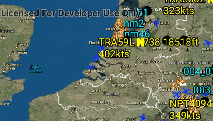
This map shows the current air traffic in parts of Europe with heading, altitude, and ground speed. Additionally, noise levels from ground monitoring stations are shown.
Tags
keyhole, KML, KMZ, network link, network link control, OGC
Sample Code
/* Copyright 2018 Esri
*
* Licensed under the Apache License, Version 2.0 (the "License");
* you may not use this file except in compliance with the License.
* You may obtain a copy of the License at
*
* http://www.apache.org/licenses/LICENSE-2.0
*
* Unless required by applicable law or agreed to in writing, software
* distributed under the License is distributed on an "AS IS" BASIS,
* WITHOUT WARRANTIES OR CONDITIONS OF ANY KIND, either express or implied.
* See the License for the specific language governing permissions and
* limitations under the License.
*
*/
package com.esri.arcgisruntime.sample.displaykmlnetworklinks;
import android.os.Bundle;
import android.util.Log;
import android.widget.Toast;
import androidx.appcompat.app.AppCompatActivity;
import com.esri.arcgisruntime.ArcGISRuntimeEnvironment;
import com.esri.arcgisruntime.layers.KmlLayer;
import com.esri.arcgisruntime.loadable.LoadStatus;
import com.esri.arcgisruntime.mapping.ArcGISMap;
import com.esri.arcgisruntime.mapping.BasemapStyle;
import com.esri.arcgisruntime.mapping.Viewpoint;
import com.esri.arcgisruntime.mapping.view.MapView;
import com.esri.arcgisruntime.ogc.kml.KmlDataset;
public class MainActivity extends AppCompatActivity {
private static final String TAG = MainActivity.class.getSimpleName();
private MapView mMapView;
@Override
protected void onCreate(Bundle savedInstanceState) {
super.onCreate(savedInstanceState);
setContentView(R.layout.activity_main);
// authentication with an API key or named user is required to access basemaps and other
// location services
ArcGISRuntimeEnvironment.setApiKey(BuildConfig.API_KEY);
// get the reference to the map view
mMapView = findViewById(R.id.mapView);
// create a map with the dark gray canvas basemap
ArcGISMap map = new ArcGISMap(BasemapStyle.ARCGIS_DARK_GRAY);
// set the map to the map view
mMapView.setMap(map);
mMapView.setViewpoint(new Viewpoint(51.960403, 10.029217, 10000000));
// create a kml data set from a URL
KmlDataset kmlDataset = new KmlDataset(getString(R.string.european_air_traffic_kml_url));
// show an alert when any network link messages are received
kmlDataset.addKmlNetworkLinkMessageReceivedListener(kmlNetworkLinkMessageReceivedEvent -> {
String message = "KML Network Link Message: " + kmlNetworkLinkMessageReceivedEvent.getMessage();
Toast.makeText(this, message, Toast.LENGTH_LONG).show();
Log.i(TAG, message);
});
// a KML layer created from a remote KML file
KmlLayer kmlLayer = new KmlLayer(kmlDataset);
// clear the existing layers from the map
mMapView.getMap().getOperationalLayers().clear();
// add the KML layer to the map as an operational layer.
mMapView.getMap().getOperationalLayers().add(kmlLayer);
// report errors if failed to load
kmlDataset.addDoneLoadingListener(() -> {
if (kmlDataset.getLoadStatus() != LoadStatus.LOADED) {
String error = "Failed to load kml layer from URL: " + kmlDataset.getLoadError().getMessage();
Toast.makeText(this, error, Toast.LENGTH_LONG).show();
Log.e(TAG, error);
}
});
}
@Override
protected void onPause() {
mMapView.pause();
super.onPause();
}
@Override
protected void onResume() {
super.onResume();
mMapView.resume();
}
@Override
protected void onDestroy() {
mMapView.dispose();
super.onDestroy();
}
}