Find the service area within a network from a given point.
Use case
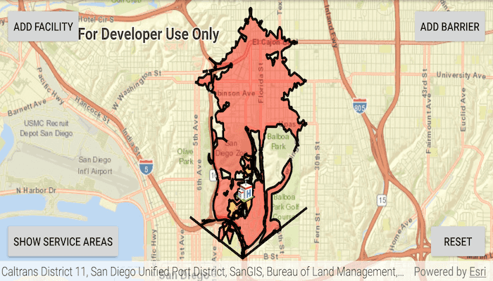
A service area shows locations that can be reached from a facility based off a certain impedance, such as travel time or distance. Barriers can increase impedance by either adding to the time it takes to pass through the barrier or by altogether preventing passage.
You might calculate the region around a hospital in which ambulances can service in 30 min or less.
How to use the sample
In order to find any service areas at least one facility needs to be added to the map view.
- To add a facility, tap the facility button, then tap anywhere on the map.
- To add a barrier, tap the barrier button, and tap multiple locations on map. Hit the barrier button again to finish drawing barrier. Hitting any other button will also stop the barrier from drawing.
- To show service areas around facilities that were added, tap show service areas button.
- The reset button clears all graphics and resets the service area task.
How it works
- Create a new
ServiceAreaTaskfrom a network service. - Create default
ServiceAreaParametersfrom the service area task. - Set the parameters to return polygons (true) to return all service areas.
- Add a
ServiceAreaFacilityto the parameters. - Get the
ServiceAreaResultby solving the service area task using the parameters. - Get any
ServiceAreaPolygonsthat were returned, serviceAreaResult.getResultPolygons(facilityIndex). - Display the service area polygons as graphics in a
GraphicsOverlayon theMapView.
Relevant API
- PolylineBarrier
- ServiceAreaFacility
- ServiceAreaParameters
- ServiceAreaPolygon
- ServiceAreaResult
- ServiceAreaTask
Tags
barriers, facilities, impedance, logistics, routing
Sample Code
MainActivity.java
/*
* Copyright 2019 Esri
*
* Licensed under the Apache License, Version 2.0 (the "License");
* you may not use this file except in compliance with the License.
* You may obtain a copy of the License at
*
* http://www.apache.org/licenses/LICENSE-2.0
*
* Unless required by applicable law or agreed to in writing, software
* distributed under the License is distributed on an "AS IS" BASIS,
* WITHOUT WARRANTIES OR CONDITIONS OF ANY KIND, either express or implied.
* See the License for the specific language governing permissions and
* limitations under the License.
*/
package com.esri.arcgisruntime.sample.findserviceareainteractive;
import java.util.ArrayList;
import java.util.Arrays;
import java.util.Collections;
import java.util.List;
import java.util.concurrent.ExecutionException;
import android.graphics.Color;
import android.os.Bundle;
import android.util.Log;
import android.view.MotionEvent;
import android.widget.Button;
import android.widget.Toast;
import androidx.appcompat.app.AppCompatActivity;
import com.esri.arcgisruntime.ArcGISRuntimeEnvironment;
import com.esri.arcgisruntime.concurrent.ListenableFuture;
import com.esri.arcgisruntime.geometry.Point;
import com.esri.arcgisruntime.geometry.Polyline;
import com.esri.arcgisruntime.geometry.PolylineBuilder;
import com.esri.arcgisruntime.mapping.ArcGISMap;
import com.esri.arcgisruntime.mapping.BasemapStyle;
import com.esri.arcgisruntime.mapping.Viewpoint;
import com.esri.arcgisruntime.mapping.view.DefaultMapViewOnTouchListener;
import com.esri.arcgisruntime.mapping.view.Graphic;
import com.esri.arcgisruntime.mapping.view.GraphicsOverlay;
import com.esri.arcgisruntime.mapping.view.MapView;
import com.esri.arcgisruntime.symbology.PictureMarkerSymbol;
import com.esri.arcgisruntime.symbology.SimpleFillSymbol;
import com.esri.arcgisruntime.symbology.SimpleLineSymbol;
import com.esri.arcgisruntime.tasks.networkanalysis.PolylineBarrier;
import com.esri.arcgisruntime.tasks.networkanalysis.ServiceAreaFacility;
import com.esri.arcgisruntime.tasks.networkanalysis.ServiceAreaParameters;
import com.esri.arcgisruntime.tasks.networkanalysis.ServiceAreaPolygon;
import com.esri.arcgisruntime.tasks.networkanalysis.ServiceAreaPolygonDetail;
import com.esri.arcgisruntime.tasks.networkanalysis.ServiceAreaResult;
import com.esri.arcgisruntime.tasks.networkanalysis.ServiceAreaTask;
public class MainActivity extends AppCompatActivity {
private static final String TAG = MainActivity.class.getSimpleName();
private MapView mMapView;
private ServiceAreaParameters mServiceAreaParameters;
private PolylineBuilder mBarrierBuilder;
@Override
protected void onCreate(Bundle savedInstanceState) {
super.onCreate(savedInstanceState);
setContentView(R.layout.activity_main);
// authentication with an API key or named user is required to access basemaps and other
// location services
ArcGISRuntimeEnvironment.setApiKey(BuildConfig.API_KEY);
// get a reference to the map view
mMapView = findViewById(R.id.mapView);
// create a map with a streets base map
ArcGISMap map = new ArcGISMap(BasemapStyle.ARCGIS_STREETS);
mMapView.setMap(map);
// set the view point to San Diego, where the service task area is
mMapView.setViewpoint(new Viewpoint(32.73, -117.14, 75000));
// create service area task from url
ServiceAreaTask serviceAreaTask = new ServiceAreaTask(this, getString(R.string.san_diego_service_area));
serviceAreaTask.loadAsync();
// create default parameters from task
ListenableFuture<ServiceAreaParameters> serviceAreaParametersFuture = serviceAreaTask
.createDefaultParametersAsync();
serviceAreaParametersFuture.addDoneListener(() -> {
try {
mServiceAreaParameters = serviceAreaParametersFuture.get();
mServiceAreaParameters.setPolygonDetail(ServiceAreaPolygonDetail.HIGH);
mServiceAreaParameters.setReturnPolygons(true);
// adding another service area of 2 minutes
// default parameters have a default service area of 5 minutes
mServiceAreaParameters.getDefaultImpedanceCutoffs().addAll(Collections.singletonList(2.0));
} catch (ExecutionException | InterruptedException e) {
String error = "Error creating service area parameters: " + e;
Log.e(TAG, error);
Toast.makeText(this, error, Toast.LENGTH_LONG).show();
}
});
// create graphics overlays to show facilities, barriers and service areas
GraphicsOverlay serviceAreasOverlay = new GraphicsOverlay();
GraphicsOverlay facilityOverlay = new GraphicsOverlay();
GraphicsOverlay barrierOverlay = new GraphicsOverlay();
mMapView.getGraphicsOverlays().addAll(Arrays.asList(serviceAreasOverlay, barrierOverlay, facilityOverlay));
mBarrierBuilder = new PolylineBuilder(mMapView.getSpatialReference());
List<ServiceAreaFacility> serviceAreaFacilities = new ArrayList<>();
SimpleLineSymbol barrierLine = new SimpleLineSymbol(SimpleLineSymbol.Style.SOLID, Color.BLACK, 3.0f);
ArrayList<SimpleFillSymbol> fillSymbols = new ArrayList<>();
fillSymbols.add(new SimpleFillSymbol(SimpleFillSymbol.Style.SOLID, getColor(R.color.colorTransparentRed), null));
fillSymbols.add(new SimpleFillSymbol(SimpleFillSymbol.Style.SOLID, getColor(R.color.colorTransparentOrange), null));
// icon used to display facilities to map view
PictureMarkerSymbol facilitySymbol = new PictureMarkerSymbol(getString(R.string.hospital_icon_url));
facilitySymbol.setHeight(30);
facilitySymbol.setWidth(30);
Button addFacilityButton = findViewById(R.id.addFacilityButton);
Button addBarrierButton = findViewById(R.id.addBarrierButton);
addFacilityButton.setOnClickListener(v -> {
addFacilityButton.setSelected(true);
addBarrierButton.setSelected(false);
});
addBarrierButton.setOnClickListener(v -> {
addBarrierButton.setSelected(true);
addFacilityButton.setSelected(false);
mBarrierBuilder = new PolylineBuilder(mMapView.getSpatialReference());
});
Button showServiceAreasButton = findViewById(R.id.showServiceAreasButton);
showServiceAreasButton.setOnClickListener(
v -> showServiceAreas(serviceAreaFacilities, barrierOverlay, serviceAreasOverlay, serviceAreaTask, fillSymbols,
addFacilityButton, addBarrierButton));
Button resetButton = findViewById(R.id.resetButton);
resetButton.setOnClickListener(
v -> clearRouteAndGraphics(addFacilityButton, addBarrierButton, serviceAreaFacilities, facilityOverlay, serviceAreasOverlay, barrierOverlay));
// creates facilities and barriers at user's clicked location
mMapView.setOnTouchListener(new DefaultMapViewOnTouchListener(this, mMapView) {
@Override public boolean onSingleTapConfirmed(MotionEvent e) {
// create a point where the user tapped
android.graphics.Point point = new android.graphics.Point(Math.round(e.getX()), Math.round(e.getY()));
Point mapPoint = mMapView.screenToLocation(point);
if (addFacilityButton.isSelected()) {
// create facility from point and display to map view
addServicePoint(mapPoint, facilitySymbol, serviceAreaFacilities, facilityOverlay);
} else if (addBarrierButton.isSelected()) {
// create barrier and display to map view
mBarrierBuilder.addPoint(new Point(mapPoint.getX(), mapPoint.getY(), mMapView.getSpatialReference()));
barrierOverlay.getGraphics()
.add(barrierOverlay.getGraphics().size(), new Graphic(mBarrierBuilder.toGeometry(), barrierLine));
}
return super.onSingleTapConfirmed(e);
}
});
}
/**
* Add the given point to the list of service areas and use it to create a facility graphic, which is then added to
* the facility overlay.
*/
private void addServicePoint(Point mapPoint, PictureMarkerSymbol facilitySymbol,
List<ServiceAreaFacility> serviceAreaFacilities, GraphicsOverlay facilityOverlay) {
Point servicePoint = new Point(mapPoint.getX(), mapPoint.getY(), mMapView.getSpatialReference());
serviceAreaFacilities.add(new ServiceAreaFacility(servicePoint));
facilityOverlay.getGraphics().add(new Graphic(servicePoint, facilitySymbol));
}
/**
* Clears all graphics from map view and clears all facilities and barriers from service area parameters.
*/
private void clearRouteAndGraphics(Button addFacilityButton, Button addBarrierButton,
List<ServiceAreaFacility> serviceAreaFacilities, GraphicsOverlay facilityOverlay,
GraphicsOverlay serviceAreasOverlay, GraphicsOverlay barrierOverlay) {
addFacilityButton.setSelected(false);
addBarrierButton.setSelected(false);
mServiceAreaParameters.clearFacilities();
mServiceAreaParameters.clearPolylineBarriers();
serviceAreaFacilities.clear();
facilityOverlay.getGraphics().clear();
serviceAreasOverlay.getGraphics().clear();
barrierOverlay.getGraphics().clear();
}
/**
* Solves the service area task using the facilities and barriers that were added to the map view.
* All service areas that are return will be displayed to the map view.
*/
private void showServiceAreas(List<ServiceAreaFacility> serviceAreaFacilities, GraphicsOverlay barrierOverlay,
GraphicsOverlay serviceAreasOverlay, ServiceAreaTask serviceAreaTask, ArrayList<SimpleFillSymbol> fillSymbols,
Button addFacilityButton, Button addBarrierButton) {
// need at least one facility for the task to work
if (!serviceAreaFacilities.isEmpty()) {
// un-select add facility and add barrier buttons
addFacilityButton.setSelected(false);
addBarrierButton.setSelected(false);
List<PolylineBarrier> polylineBarriers = new ArrayList<>();
for (Graphic barrierGraphic : barrierOverlay.getGraphics()) {
polylineBarriers.add(new PolylineBarrier((Polyline) barrierGraphic.getGeometry()));
mServiceAreaParameters.setPolylineBarriers(polylineBarriers);
}
serviceAreasOverlay.getGraphics().clear();
mServiceAreaParameters.setFacilities(serviceAreaFacilities);
// find service areas around facility using parameters that were set
ListenableFuture<ServiceAreaResult> result = serviceAreaTask.solveServiceAreaAsync(mServiceAreaParameters);
result.addDoneListener(() -> {
try {
// display all service areas that were found to mapview
List<Graphic> graphics = serviceAreasOverlay.getGraphics();
ServiceAreaResult serviceAreaResult = result.get();
for (int i = 0; i < serviceAreaFacilities.size(); i++) {
List<ServiceAreaPolygon> polygons = serviceAreaResult.getResultPolygons(i);
// could be more than one service area
for (int j = 0; j < polygons.size(); j++) {
graphics.add(new Graphic(polygons.get(j).getGeometry(), fillSymbols.get(j % 2)));
}
}
} catch (ExecutionException | InterruptedException e) {
String error = e.getMessage().contains("Unable to complete operation") ?
"Facility not within San Diego area!" + e :
"Error getting the service area result: " + e;
Log.e(TAG, error);
Toast.makeText(this, error, Toast.LENGTH_LONG).show();
}
});
} else {
Toast.makeText(this, "Must have at least one Facility on the map!", Toast.LENGTH_LONG).show();
}
}
@Override
protected void onPause() {
mMapView.pause();
super.onPause();
}
@Override
protected void onResume() {
super.onResume();
mMapView.resume();
}
@Override
protected void onDestroy() {
mMapView.dispose();
super.onDestroy();
}
}