Display KML from a URL, portal item, or local KML file.
Use case
Keyhole Markup Language (KML) is a data format used by Google Earth. KML is popular as a transmission format for consumer use and for sharing geographic data between apps. You can use Runtime to display KML files, with full support for a variety of features, including network links, 3D models, screen overlays, and tours.
How to use the sample
Use the overflow menu to select a source. A KML file from that source will be loaded and displayed in the map.
How it works
- To create a KML layer from a URL, create a
KmlDatasetusing the URL to the KML file. Then pass the dataset to theKmlLayerconstructor. - To create a KML layer from a portal item, construct a
PortalItemwith aPortaland the KML portal item ID. Pass the portal item to theKmlLayerconstructor. - To create a KML layer from a local file, create a
KmlDatasetusing the absolute file path to the local KML file. Then pass the dataset to theKmlLayerconstructor. - Add the layer as an operational layer to the map with
map.getOperationalLayers().add(kmlLayer).
Relevant API
- KmlDataset
- KmlLayer
Offline Data
- Download the data from ArcGIS Online.
- Open your command prompt and navigate to the folder where you extracted the contents of the data from step 1.
- Push the data into the scoped storage of the sample app:
adb push US_State_Capitals.kml /Android/data/com.esri.arcgisruntime.sample.displaykml/files/US_State_Capitals.kml
About the data
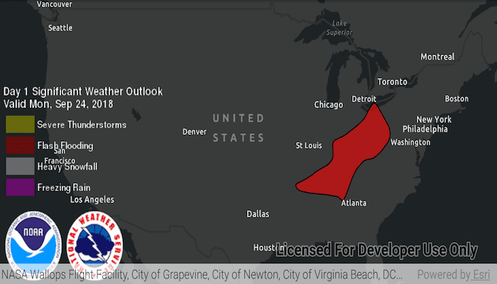
This sample displays three different KML files:
- From URL - this is a map of the significant weather outlook produced by NOAA/NWS. It uses KML network links to always show the latest data.
- From local file - this is a map of U.S. state capitals. It doesn't define an icon, so the default pushpin is used for the points.
- From portal item - this is a map of U.S. states.
Tags
keyhole, KML, KMZ, OGC
Sample Code
MainActivity.java
/* Copyright 2018 Esri
*
* Licensed under the Apache License, Version 2.0 (the "License");
* you may not use this file except in compliance with the License.
* You may obtain a copy of the License at
*
* http://www.apache.org/licenses/LICENSE-2.0
*
* Unless required by applicable law or agreed to in writing, software
* distributed under the License is distributed on an "AS IS" BASIS,
* WITHOUT WARRANTIES OR CONDITIONS OF ANY KIND, either express or implied.
* See the License for the specific language governing permissions and
* limitations under the License.
*
*/
package com.esri.arcgisruntime.sample.displaykml;
import android.os.Bundle;
import android.util.Log;
import android.view.Menu;
import android.view.MenuInflater;
import android.view.MenuItem;
import android.widget.Toast;
import androidx.appcompat.app.AppCompatActivity;
import com.esri.arcgisruntime.ArcGISRuntimeEnvironment;
import com.esri.arcgisruntime.layers.KmlLayer;
import com.esri.arcgisruntime.loadable.LoadStatus;
import com.esri.arcgisruntime.mapping.ArcGISMap;
import com.esri.arcgisruntime.mapping.BasemapStyle;
import com.esri.arcgisruntime.mapping.Viewpoint;
import com.esri.arcgisruntime.mapping.view.MapView;
import com.esri.arcgisruntime.ogc.kml.KmlDataset;
import com.esri.arcgisruntime.portal.Portal;
import com.esri.arcgisruntime.portal.PortalItem;
public class MainActivity extends AppCompatActivity {
private static final String TAG = MainActivity.class.getSimpleName();
private MapView mMapView;
@Override
protected void onCreate(Bundle savedInstanceState) {
super.onCreate(savedInstanceState);
setContentView(R.layout.activity_main);
// authentication with an API key or named user is required to access basemaps and other
// location services
ArcGISRuntimeEnvironment.setApiKey(BuildConfig.API_KEY);
// get the reference to the map view
mMapView = findViewById(R.id.mapView);
// create a map with the dark gray canvas basemap
ArcGISMap map = new ArcGISMap(BasemapStyle.ARCGIS_DARK_GRAY);
// set the map to the map view
mMapView.setMap(map);
mMapView.setViewpoint(new Viewpoint(39, -98, 100000000));
// set the initial source to a KML layer from a URL
changeSourceToURL();
}
/**
* Clear all operational layers and add the kml layer to the map as an operational layer.
*
* @param kmlLayer to add to the map
*/
private void display(KmlLayer kmlLayer) {
// clear the existing layers from the map
mMapView.getMap().getOperationalLayers().clear();
// add the KML layer to the map
mMapView.getMap().getOperationalLayers().add(kmlLayer);
}
/**
* Display a kml layer from a URL.
*/
private void changeSourceToURL() {
// create a kml data set from a URL
KmlDataset kmlDataset = new KmlDataset(getString(R.string.noaa_weather_kml_url));
// a KML layer created from a remote KML file
KmlLayer kmlLayer = new KmlLayer(kmlDataset);
display(kmlLayer);
// report errors if failed to load
kmlDataset.addDoneLoadingListener(() -> {
if (kmlDataset.getLoadStatus() != LoadStatus.LOADED) {
String error = "Failed to load kml layer from URL: " + kmlDataset.getLoadError().getMessage();
Toast.makeText(this, error, Toast.LENGTH_LONG).show();
Log.e(TAG, error);
}
});
}
/**
* Display a kml layer from a portal item.
*/
private void changeSourceToPortalItem() {
// create a portal to ArcGIS Online
Portal portal = new Portal(getString(R.string.arcgis_online_url));
// create a portal item from a kml item id
PortalItem portalItem = new PortalItem(portal, getString(R.string.kml_item_id));
// a KML layer created from an ArcGIS Online portal item
KmlLayer kmlLayer = new KmlLayer(portalItem);
display(kmlLayer);
// report errors if failed to load
kmlLayer.addDoneLoadingListener(() -> {
if (kmlLayer.getLoadStatus() != LoadStatus.LOADED) {
String error = "Failed to load kml layer from portal item: " + kmlLayer.getLoadError().getCause().getMessage();
Toast.makeText(this, error, Toast.LENGTH_LONG).show();
Log.e(TAG, error);
}
});
}
/**
* Display a kml layer from external storage.
*/
private void changeSourceToFileExternalStorage() {
// a data set made from data in external storage
KmlDataset kmlDataset = new KmlDataset(getExternalFilesDir(null) + getString(R.string.kml_path));
// a KML layer created from a local KML file
KmlLayer kmlLayer = new KmlLayer(kmlDataset);
display(kmlLayer);
// report errors if failed to load
kmlDataset.addDoneLoadingListener(() -> {
if (kmlDataset.getLoadStatus() != LoadStatus.LOADED) {
String error =
"Failed to load kml data set from external storage: " + kmlDataset.getLoadError().getCause().getMessage();
Toast.makeText(this, error, Toast.LENGTH_LONG).show();
Log.e(TAG, error);
}
});
}
@Override public boolean onCreateOptionsMenu(Menu menu) {
MenuInflater inflater = getMenuInflater();
inflater.inflate(R.menu.kml_sources, menu);
return super.onCreateOptionsMenu(menu);
}
@Override public boolean onOptionsItemSelected(MenuItem item) {
int i = item.getItemId();
if (i == R.id.kmlFromUrl) {
changeSourceToURL();
} else if (i == R.id.kmlFromPortal) {
changeSourceToPortalItem();
} else if (i == R.id.kmlFromExternalStorage) {
changeSourceToFileExternalStorage();
} else {
Log.e(TAG, "Menu option not implemented");
}
return super.onOptionsItemSelected(item);
}
@Override
protected void onPause() {
mMapView.pause();
super.onPause();
}
@Override
protected void onResume() {
super.onResume();
mMapView.resume();
}
@Override
protected void onDestroy() {
mMapView.dispose();
super.onDestroy();
}
}