Find the location for an address.
Use case
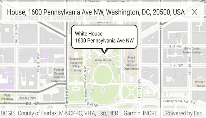
A user can input a raw address into your app's search bar and zoom to the address location.
How to use the sample
Type in an address in the search view at the top of the screen. Suggestions will appear as text is entered. Tap a suggestion or enter your own text to see the address marked with a pin. Tapping on the pin will show the address in a callout.
How it works
- Create a
LocatorTaskusing the URL to a locator service. - Set the
GeocodeParametersfor the locator task and specify the geocode's attributes. - Get the matching results from the
GeocodeResultusinglocatorTask.geocodeAsync(addressString, geocodeParameters). - Create a
Graphicwith the geocode result's location and store the geocode result's attributes in the graphic's attributes. - Show the graphic in a
GraphicsOverlay.
Relevant API
- GeocodeParameters
- GeocodeResult
- LocatorTask
Additional information
This sample uses the World Geocoding Service. For more information, see the Geocoding service help topic on the ArcGIS Developer website.
Tags
address, geocode, locator, search
Sample Code
MainActivity.java
/* Copyright 2017 Esri
*
* Licensed under the Apache License, Version 2.0 (the "License");
* you may not use this file except in compliance with the License.
* You may obtain a copy of the License at
*
* http://www.apache.org/licenses/LICENSE-2.0
*
* Unless required by applicable law or agreed to in writing, software
* distributed under the License is distributed on an "AS IS" BASIS,
* WITHOUT WARRANTIES OR CONDITIONS OF ANY KIND, either express or implied.
* See the License for the specific language governing permissions and
* limitations under the License.
*
*/
package com.esri.arcgisruntime.sample.findaddress;
import android.database.MatrixCursor;
import android.graphics.Color;
import android.graphics.drawable.BitmapDrawable;
import android.os.Bundle;
import android.provider.BaseColumns;
import android.util.Log;
import android.view.MotionEvent;
import android.widget.TextView;
import android.widget.Toast;
import androidx.appcompat.app.AppCompatActivity;
import androidx.appcompat.widget.SearchView;
import androidx.core.content.ContextCompat;
import androidx.cursoradapter.widget.SimpleCursorAdapter;
import com.esri.arcgisruntime.ArcGISRuntimeEnvironment;
import com.esri.arcgisruntime.concurrent.ListenableFuture;
import com.esri.arcgisruntime.geometry.Point;
import com.esri.arcgisruntime.loadable.LoadStatus;
import com.esri.arcgisruntime.mapping.ArcGISMap;
import com.esri.arcgisruntime.mapping.BasemapStyle;
import com.esri.arcgisruntime.mapping.Viewpoint;
import com.esri.arcgisruntime.mapping.view.Callout;
import com.esri.arcgisruntime.mapping.view.DefaultMapViewOnTouchListener;
import com.esri.arcgisruntime.mapping.view.Graphic;
import com.esri.arcgisruntime.mapping.view.GraphicsOverlay;
import com.esri.arcgisruntime.mapping.view.IdentifyGraphicsOverlayResult;
import com.esri.arcgisruntime.mapping.view.MapView;
import com.esri.arcgisruntime.symbology.PictureMarkerSymbol;
import com.esri.arcgisruntime.tasks.geocode.GeocodeParameters;
import com.esri.arcgisruntime.tasks.geocode.GeocodeResult;
import com.esri.arcgisruntime.tasks.geocode.LocatorTask;
import com.esri.arcgisruntime.tasks.geocode.SuggestResult;
import java.util.List;
import java.util.concurrent.ExecutionException;
public class MainActivity extends AppCompatActivity {
private final String TAG = MainActivity.class.getSimpleName();
private final String COLUMN_NAME_ADDRESS = "address";
private final String[] mColumnNames = { BaseColumns._ID, COLUMN_NAME_ADDRESS };
private SearchView mAddressSearchView;
private MapView mMapView;
private LocatorTask mLocatorTask;
private GraphicsOverlay mGraphicsOverlay;
private GeocodeParameters mAddressGeocodeParameters;
private PictureMarkerSymbol mPinSourceSymbol;
private Callout mCallout;
@Override
protected void onCreate(Bundle savedInstanceState) {
super.onCreate(savedInstanceState);
setContentView(R.layout.activity_main);
// authentication with an API key or named user is required to access basemaps and other
// location services
ArcGISRuntimeEnvironment.setApiKey(BuildConfig.API_KEY);
// inflate address search view
mAddressSearchView = findViewById(R.id.addressSearchView);
mAddressSearchView.setIconified(false);
mAddressSearchView.setFocusable(false);
mAddressSearchView.setQueryHint(getResources().getString(R.string.address_search_hint));
// define pin drawable
BitmapDrawable pinDrawable = (BitmapDrawable) ContextCompat.getDrawable(this, R.drawable.pin);
try {
mPinSourceSymbol = PictureMarkerSymbol.createAsync(pinDrawable).get();
} catch (InterruptedException | ExecutionException e) {
Log.e(TAG, "Picture Marker Symbol error: " + e.getMessage());
Toast.makeText(getApplicationContext(), "Failed to load pin drawable.", Toast.LENGTH_LONG).show();
}
// set pin to half of native size
mPinSourceSymbol.setWidth(19f);
mPinSourceSymbol.setHeight(72f);
// create a LocatorTask from an online service
mLocatorTask = new LocatorTask("https://geocode-api.arcgis.com/arcgis/rest/services/World/GeocodeServer");
// inflate MapView from layout
mMapView = findViewById(R.id.mapView);
// create a map with the BasemapType topographic
final ArcGISMap map = new ArcGISMap(BasemapStyle.ARCGIS_STREETS);
map.setInitialViewpoint(new Viewpoint(40,-100,100000000));
// once the map has loaded successfully, set up address finding UI
map.addDoneLoadingListener(() -> {
if (map.getLoadStatus() == LoadStatus.LOADED) {
setupAddressSearchView();
} else {
Log.e(TAG, "Map failed to load: " + map.getLoadError().getMessage());
Toast.makeText(
getApplicationContext(),
"Map failed to load: " + map.getLoadError().getMessage(),
Toast.LENGTH_LONG
).show();
}
});
// set the map to be displayed in this view
mMapView.setMap(map);
// set the map viewpoint to start over North America
mMapView.setViewpoint(new Viewpoint(40, -100, 100000000));
// add listener to handle screen taps
mMapView.setOnTouchListener(new DefaultMapViewOnTouchListener(this, mMapView) {
@Override
public boolean onSingleTapConfirmed(MotionEvent motionEvent) {
identifyGraphic(motionEvent);
return true;
}
});
// define the graphics overlay
mGraphicsOverlay = new GraphicsOverlay();
}
/**
* Sets up the address SearchView. Uses MatrixCursor to show suggestions to the user as the user inputs text.
*/
private void setupAddressSearchView() {
mAddressGeocodeParameters = new GeocodeParameters();
// get place name and address attributes
mAddressGeocodeParameters.getResultAttributeNames().add("PlaceName");
mAddressGeocodeParameters.getResultAttributeNames().add("Place_addr");
// return only the closest result
mAddressGeocodeParameters.setMaxResults(1);
mAddressSearchView.setOnQueryTextListener(new SearchView.OnQueryTextListener() {
@Override
public boolean onQueryTextSubmit(String address) {
// geocode typed address
geoCodeTypedAddress(address);
// clear focus from search views
mAddressSearchView.clearFocus();
return true;
}
@Override
public boolean onQueryTextChange(String newText) {
// as long as newText isn't empty, get suggestions from the locatorTask
if (!newText.equals("")) {
final ListenableFuture<List<SuggestResult>> suggestionsFuture = mLocatorTask.suggestAsync(newText);
suggestionsFuture.addDoneListener(new Runnable() {
@Override public void run() {
try {
// get the results of the async operation
List<SuggestResult> suggestResults = suggestionsFuture.get();
MatrixCursor suggestionsCursor = new MatrixCursor(mColumnNames);
int key = 0;
// add each address suggestion to a new row
for (SuggestResult result : suggestResults) {
suggestionsCursor.addRow(new Object[] { key++, result.getLabel() });
}
// define SimpleCursorAdapter
String[] cols = new String[] { COLUMN_NAME_ADDRESS };
int[] to = new int[] { R.id.suggestion_address };
final SimpleCursorAdapter suggestionAdapter = new SimpleCursorAdapter(MainActivity.this,
R.layout.find_address_suggestion, suggestionsCursor, cols, to, 0);
mAddressSearchView.setSuggestionsAdapter(suggestionAdapter);
// handle an address suggestion being chosen
mAddressSearchView.setOnSuggestionListener(new SearchView.OnSuggestionListener() {
@Override public boolean onSuggestionSelect(int position) {
return false;
}
@Override public boolean onSuggestionClick(int position) {
// get the selected row
MatrixCursor selectedRow = (MatrixCursor) suggestionAdapter.getItem(position);
// get the row's index
int selectedCursorIndex = selectedRow.getColumnIndex(COLUMN_NAME_ADDRESS);
// get the string from the row at index
String address = selectedRow.getString(selectedCursorIndex);
// use clicked suggestion as query
mAddressSearchView.setQuery(address, true);
return true;
}
});
} catch (Exception e) {
Log.e(TAG, "Geocode suggestion error: " + e.getMessage());
}
}
});
}
return true;
}
});
}
/**
* Identifies the Graphic at the tapped point.
*
* @param motionEvent containing a tapped screen point
*/
private void identifyGraphic(MotionEvent motionEvent) {
// get the screen point
android.graphics.Point screenPoint = new android.graphics.Point(Math.round(motionEvent.getX()),
Math.round(motionEvent.getY()));
// from the graphics overlay, get graphics near the tapped location
final ListenableFuture<IdentifyGraphicsOverlayResult> identifyResultsFuture = mMapView
.identifyGraphicsOverlayAsync(mGraphicsOverlay, screenPoint, 10, false);
identifyResultsFuture.addDoneListener(new Runnable() {
@Override public void run() {
try {
IdentifyGraphicsOverlayResult identifyGraphicsOverlayResult = identifyResultsFuture.get();
List<Graphic> graphics = identifyGraphicsOverlayResult.getGraphics();
// if a graphic has been identified
if (!graphics.isEmpty()) {
//get the first graphic identified
Graphic identifiedGraphic = graphics.get(0);
showCallout(identifiedGraphic);
} else {
// if no graphic identified
mCallout.dismiss();
}
} catch (Exception e) {
Log.e(TAG, "Identify error: " + e.getMessage());
}
}
});
}
/**
* Shows the Graphic's attributes as a Callout.
*
* @param graphic containing attributes
*/
private void showCallout(final Graphic graphic) {
// create a TextView for the Callout
TextView calloutContent = new TextView(getApplicationContext());
calloutContent.setTextColor(Color.BLACK);
// set the text of the Callout to graphic's attributes
if (graphic.getAttributes().get("PlaceName").toString().isEmpty()) {
calloutContent.setText(graphic.getAttributes().get("Place_addr").toString());
} else {
calloutContent.setText(graphic.getAttributes().get("PlaceName") + "\n"
+ graphic.getAttributes().get("Place_addr"));
}
// get Callout
mCallout = mMapView.getCallout();
// set Callout options: animateCallout: true, recenterMap: false, animateRecenter: false
mCallout.setShowOptions(new Callout.ShowOptions(true, false, false));
mCallout.setContent(calloutContent);
// set the leader position and show the callout
// set the leader position and show the callout
Point calloutLocation = graphic.computeCalloutLocation(graphic.getGeometry().getExtent().getCenter(), mMapView);
mCallout.setGeoElement(graphic, calloutLocation);
mCallout.show();
}
/**
* Geocode an address passed in by the user.
*
* @param address read in from searchViews
*/
private void geoCodeTypedAddress(final String address) {
// check that address isn't null
if (address != null) {
// Execute async task to find the address
mLocatorTask.addDoneLoadingListener(new Runnable() {
@Override
public void run() {
if (mLocatorTask.getLoadStatus() == LoadStatus.LOADED) {
// Call geocodeAsync passing in an address
final ListenableFuture<List<GeocodeResult>> geocodeResultListenableFuture = mLocatorTask
.geocodeAsync(address, mAddressGeocodeParameters);
geocodeResultListenableFuture.addDoneListener(new Runnable() {
@Override
public void run() {
try {
// Get the results of the async operation
List<GeocodeResult> geocodeResults = geocodeResultListenableFuture.get();
if (geocodeResults.size() > 0) {
displaySearchResult(geocodeResults.get(0));
} else {
Toast.makeText(getApplicationContext(), getString(R.string.location_not_found) + address,
Toast.LENGTH_LONG).show();
}
} catch (InterruptedException | ExecutionException e) {
Log.e(TAG, "Geocode error: " + e.getMessage());
Toast.makeText(getApplicationContext(), getString(R.string.geo_locate_error), Toast.LENGTH_LONG)
.show();
}
}
});
} else {
Log.i(TAG, "Trying to reload locator task");
mLocatorTask.retryLoadAsync();
}
}
});
mLocatorTask.loadAsync();
}
}
/**
* Turns a GeocodeResult into a Point and adds it to a GraphicOverlay which is then drawn on the map.
*
* @param geocodeResult a single geocode result
*/
private void displaySearchResult(GeocodeResult geocodeResult) {
// dismiss any callout
if (mMapView.getCallout() != null && mMapView.getCallout().isShowing()) {
mMapView.getCallout().dismiss();
}
// clear map of existing graphics
mMapView.getGraphicsOverlays().clear();
mGraphicsOverlay.getGraphics().clear();
// create graphic object for resulting location
Point resultPoint = geocodeResult.getDisplayLocation();
Graphic resultLocGraphic = new Graphic(resultPoint, geocodeResult.getAttributes(), mPinSourceSymbol);
// add graphic to location layer
mGraphicsOverlay.getGraphics().add(resultLocGraphic);
// zoom map to result over 3 seconds
mMapView.setViewpointAsync(new Viewpoint(geocodeResult.getExtent()), 3).addDoneListener(() -> showCallout(resultLocGraphic));
// set the graphics overlay to the map
mMapView.getGraphicsOverlays().add(mGraphicsOverlay);
}
@Override
protected void onPause() {
super.onPause();
mMapView.pause();
}
@Override
protected void onResume() {
super.onResume();
mMapView.resume();
}
@Override
protected void onDestroy() {
super.onDestroy();
mMapView.dispose();
}
}