Find routes from several locations to the respective closest facility.
Use case
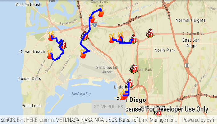
Quickly and accurately determining the most efficient route between a location and a facility is a frequently encountered task. For example, a city's fire department may need to know which firestations in the vicinity offer the quickest routes to multiple fires. Solving for the closest fire station to the fire's location using an impedance of "travel time" would provide this information.
How to use the sample
Tap the 'Solve Routes' button to solve and display the route from each incident (fire) to the nearest facility (fire station).
How it works
- Create a
ClosestFacilityTaskusing a URL from an online service. - Get the default set of
ClosestFacilityParametersfrom the task:closestFacilityTask.createDefaultParametersAsync().get(). - Build a list of all
FacilitiesandIncidents:
- Create a
FeatureTableusingServiceFeatureTable(Uri). - Query the
FeatureTablefor allFeaturesusingqueryFeaturesAsync(queryParameters). - Iterate over the result and add each
Featureto theList, instantiating the feature as aFacilityorIncident.
- Add a list of all facilities to the task parameters:
closestFacilityParameters.setFacilities(facilitiesList). - Add a list of all incidents to the task parameters:
closestFacilityParameters.setIncidents(incidentsList). - Get
ClosestFacilityResultby solving the task with the provided parameters:closestFacilityTask.solveClosestFacilityAsync(closestFacilityParameters). - Find the closest facility for each incident by iterating over the list of
Incidents. - Display the route as a
Graphicusing theclosestFacilityRoute.getRouteGeometry().
Relevant API
- ClosestFacilityParameters
- ClosestFacilityResult
- ClosestFacilityRoute
- ClosestFacilityTask
- Facility
- Graphic
- GraphicsOverlay
- Incident
Tags
incident, network analysis, route, search
Sample Code
MainActivity.java
/*
* Copyright 2019 Esri
*
* Licensed under the Apache License, Version 2.0 (the "License");
* you may not use this file except in compliance with the License.
* You may obtain a copy of the License at
*
* http://www.apache.org/licenses/LICENSE-2.0
*
* Unless required by applicable law or agreed to in writing, software
* distributed under the License is distributed on an "AS IS" BASIS,
* WITHOUT WARRANTIES OR CONDITIONS OF ANY KIND, either express or implied.
* See the License for the specific language governing permissions and
* limitations under the License.
*/
package com.esri.arcgisruntime.sample.findclosestfacilitytomultipleincidentsservice;
import java.util.ArrayList;
import java.util.Arrays;
import java.util.List;
import java.util.concurrent.ExecutionException;
import android.graphics.Color;
import android.os.Bundle;
import android.util.Log;
import android.widget.Button;
import android.widget.Toast;
import androidx.appcompat.app.AppCompatActivity;
import com.esri.arcgisruntime.ArcGISRuntimeEnvironment;
import com.esri.arcgisruntime.concurrent.ListenableFuture;
import com.esri.arcgisruntime.data.Feature;
import com.esri.arcgisruntime.data.FeatureQueryResult;
import com.esri.arcgisruntime.data.FeatureTable;
import com.esri.arcgisruntime.data.QueryParameters;
import com.esri.arcgisruntime.data.ServiceFeatureTable;
import com.esri.arcgisruntime.geometry.Envelope;
import com.esri.arcgisruntime.geometry.GeometryEngine;
import com.esri.arcgisruntime.geometry.Point;
import com.esri.arcgisruntime.layers.FeatureLayer;
import com.esri.arcgisruntime.loadable.LoadStatus;
import com.esri.arcgisruntime.mapping.ArcGISMap;
import com.esri.arcgisruntime.mapping.BasemapStyle;
import com.esri.arcgisruntime.mapping.view.Graphic;
import com.esri.arcgisruntime.mapping.view.GraphicsOverlay;
import com.esri.arcgisruntime.mapping.view.MapView;
import com.esri.arcgisruntime.symbology.PictureMarkerSymbol;
import com.esri.arcgisruntime.symbology.SimpleLineSymbol;
import com.esri.arcgisruntime.symbology.SimpleRenderer;
import com.esri.arcgisruntime.tasks.networkanalysis.ClosestFacilityParameters;
import com.esri.arcgisruntime.tasks.networkanalysis.ClosestFacilityResult;
import com.esri.arcgisruntime.tasks.networkanalysis.ClosestFacilityRoute;
import com.esri.arcgisruntime.tasks.networkanalysis.ClosestFacilityTask;
import com.esri.arcgisruntime.tasks.networkanalysis.Facility;
import com.esri.arcgisruntime.tasks.networkanalysis.Incident;
public class MainActivity extends AppCompatActivity {
private static final String TAG = MainActivity.class.getSimpleName();
private MapView mMapView;
// objects that implement Loadable must be class fields to prevent being garbage collected before loading
private ClosestFacilityTask mClosestFacilityTask;
@Override
protected void onCreate(Bundle savedInstanceState) {
super.onCreate(savedInstanceState);
setContentView(R.layout.activity_main);
// authentication with an API key or named user is required to access basemaps and other
// location services
ArcGISRuntimeEnvironment.setApiKey(BuildConfig.API_KEY);
// get a reference to the solve routes button and disable it
Button solveRoutesButton = findViewById(R.id.solveRoutesButton);
solveRoutesButton.setEnabled(false);
// get a reference to the map view
mMapView = findViewById(R.id.mapView);
// create a ArcGISMap with a Basemap instance with an Imagery base layer
ArcGISMap map = new ArcGISMap(BasemapStyle.ARCGIS_STREETS_RELIEF);
mMapView.setMap(map);
// create a graphics overlay and add it to the map
GraphicsOverlay graphicsOverlay = new GraphicsOverlay();
mMapView.getGraphicsOverlays().add(graphicsOverlay);
// create Symbols for displaying facilities
PictureMarkerSymbol facilitySymbol = new PictureMarkerSymbol(getString(R.string.fire_station_symbol_url));
facilitySymbol.setHeight(30);
facilitySymbol.setWidth(30);
PictureMarkerSymbol incidentSymbol = new PictureMarkerSymbol(getString(R.string.crime_symbol_url));
incidentSymbol.setHeight(30);
incidentSymbol.setWidth(30);
// create a line symbol to mark the route
SimpleLineSymbol simpleLineSymbol = new SimpleLineSymbol(SimpleLineSymbol.Style.SOLID, Color.BLUE, 5.0f);
// create a closest facility task from a network analysis service
mClosestFacilityTask = new ClosestFacilityTask(this,
getString(R.string.san_diego_network_analysis_service_url));
// create a table for facilities using the feature service
FeatureTable facilitiesFeatureTable = new ServiceFeatureTable(getString(R.string.san_diego_facilities_service_url));
// create a feature layer from the table, apply facilities icon
FeatureLayer facilitiesFeatureLayer = new FeatureLayer(facilitiesFeatureTable);
facilitiesFeatureLayer.setRenderer(new SimpleRenderer(facilitySymbol));
// create a table for incidents using the feature service
FeatureTable incidentsFeatureTable = new ServiceFeatureTable(getString(R.string.san_diego_incidents_service_url));
// create a feature layer from the table, apply incident icon
FeatureLayer incidentsFeatureLayer = new FeatureLayer(incidentsFeatureTable);
incidentsFeatureLayer.setRenderer(new SimpleRenderer(incidentSymbol));
// add the layers to the map
map.getOperationalLayers().addAll(Arrays.asList(facilitiesFeatureLayer, incidentsFeatureLayer));
// create the list to store the facilities
List<Facility> facilities = new ArrayList<>();
// create the list to store the incidents
List<Incident> incidents = new ArrayList<>();
// wait for the feature layers to load to retrieve the facilities and incidents
facilitiesFeatureLayer.addDoneLoadingListener(() -> incidentsFeatureLayer.addDoneLoadingListener(() -> {
if (facilitiesFeatureLayer.getLoadStatus() == LoadStatus.LOADED
&& incidentsFeatureLayer.getLoadStatus() == LoadStatus.LOADED) {
// zoom to the extent of the combined feature layers
Envelope fullFeatureLayerExtent = GeometryEngine
.combineExtents(facilitiesFeatureLayer.getFullExtent(), incidentsFeatureLayer.getFullExtent());
mMapView.setViewpointGeometryAsync(fullFeatureLayerExtent, 90);
// create query parameters to select all features
QueryParameters queryParameters = new QueryParameters();
queryParameters.setWhereClause("1=1");
// retrieve a list of all facilities
ListenableFuture<FeatureQueryResult> result = facilitiesFeatureTable.queryFeaturesAsync(queryParameters);
result.addDoneListener(() -> {
try {
FeatureQueryResult facilitiesResult = result.get();
// add the found facilities to the list
for (Feature facilityFeature : facilitiesResult) {
// since we know our feature layer only contains point features, we can cast them as Point in order to create a Facility
facilities.add(new Facility((Point) facilityFeature.getGeometry()));
}
} catch (InterruptedException | ExecutionException e) {
String error = "Error retrieving list of facilities: " + e.getMessage();
Toast.makeText(this, error, Toast.LENGTH_LONG).show();
Log.e(TAG, error);
}
});
// retrieve a list of all incidents
ListenableFuture<FeatureQueryResult> incidentsQueryResult = incidentsFeatureTable
.queryFeaturesAsync(queryParameters);
incidentsQueryResult.addDoneListener(() -> {
try {
FeatureQueryResult incidentsResult = incidentsQueryResult.get();
// add the found incidents to the list
for (Feature incidentFeature : incidentsResult) {
// since we know our feature layer only contains point features, we can cast them as Point in order to create an Incident
incidents.add(new Incident((Point) incidentFeature.getGeometry()));
}
} catch (InterruptedException | ExecutionException e) {
String error = "Error retrieving list of incidents: " + e.getMessage();
Toast.makeText(this, error, Toast.LENGTH_LONG).show();
Log.e(TAG, error);
}
});
// enable the 'solve routes' button
solveRoutesButton.setEnabled(true);
// resolve button press
solveRoutesButton.setOnClickListener(v -> {
// disable the 'solve routes' button and show the progress indicator
solveRoutesButton.setEnabled(false);
// start the routing task
mClosestFacilityTask.loadAsync();
mClosestFacilityTask.addDoneLoadingListener(() -> {
if (mClosestFacilityTask.getLoadStatus() == LoadStatus.LOADED) {
try {
// create default parameters for the task and add facilities and incidents to parameters
ClosestFacilityParameters closestFacilityParameters = mClosestFacilityTask
.createDefaultParametersAsync().get();
closestFacilityParameters.setFacilities(facilities);
closestFacilityParameters.setIncidents(incidents);
// solve closest facilities
try {
// use the task to solve for the closest facility
ListenableFuture<ClosestFacilityResult> closestFacilityTaskResult = mClosestFacilityTask
.solveClosestFacilityAsync(closestFacilityParameters);
closestFacilityTaskResult.addDoneListener(() -> {
try {
ClosestFacilityResult closestFacilityResult = closestFacilityTaskResult.get();
// find the closest facility for each incident
for (int i = 0; i < incidents.size(); i++) {
// get the index of the closest facility to incident
Integer closestFacilityIndex = closestFacilityResult.getRankedFacilityIndexes(i).get(0);
// get the route to the closest facility
ClosestFacilityRoute closestFacilityRoute = closestFacilityResult
.getRoute(closestFacilityIndex, i);
// display the route on the graphics overlay
graphicsOverlay.getGraphics()
.add(new Graphic(closestFacilityRoute.getRouteGeometry(), simpleLineSymbol));
}
} catch (ExecutionException | InterruptedException ex) {
String error = "Error getting the closest facility task result: " + ex.getMessage();
Toast.makeText(this, error, Toast.LENGTH_LONG).show();
Log.e(TAG, error);
}
});
} catch (Exception ex) {
String error = "Error solving the closest facility task: " + ex.getMessage();
Toast.makeText(this, error, Toast.LENGTH_LONG).show();
Log.e(TAG, error);
}
} catch (InterruptedException | ExecutionException ex) {
String error = "Error getting default route parameters: " + ex.getMessage();
Toast.makeText(this, error, Toast.LENGTH_LONG).show();
Log.e(TAG, error);
}
} else {
String error = "Error loading route task: " + mClosestFacilityTask.getLoadError().getMessage();
Toast.makeText(this, error, Toast.LENGTH_LONG).show();
Log.e(TAG, error);
}
});
});
}
})
);
}
@Override
protected void onPause() {
mMapView.pause();
super.onPause();
}
@Override
protected void onResume() {
super.onResume();
mMapView.resume();
}
@Override
protected void onDestroy() {
mMapView.dispose();
super.onDestroy();
}
}