Display a raster contained in a GeoPackage.
Use case
GeoPackages are designed to simplify file management and transfer. They can store raster files (as well as other types of data). An end-user wishing to transfer rasters from ArcGIS Pro or between runtime apps might need to import raster files from GeoPackages into their map to view and analyze the data.
How to use the sample
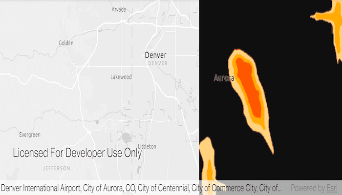
When the sample starts, a raster will be loaded from a GeoPackage and displayed in the map view.
How it works
- Create and load a
GeoPackage, specifying the path to the local .gpkg file. - When it is done loading, get the
GeoPackageRasters from the geopackage. - Construct a
RasterLayerwith the geopackage raster you want to use. - Add the raster layer to the map.
Relevant API
- GeoPackage
- GeoPackageRaster
- RasterLayer
Offline Data
- Download the data from ArcGIS Online.
- Extract the contents of the downloaded zip file to disk.
- Open your command prompt and navigate to the folder where you extracted the contents of the data from step 1.
- Push the data into the scoped storage of the sample app:
adb push AuroraCO.gpkg /Android/data/com.esri.arcgisruntime.sample.rasterlayergeopackage/files/AuroraCO.gpkg
Tags
container, data, image, import, layer, OGC, package, raster, visualization
Sample Code
MainActivity.java
/*
* Copyright 2018 Esri
*
* Licensed under the Apache License, Version 2.0 (the "License");
* you may not use this file except in compliance with the License.
* You may obtain a copy of the License at
*
* http://www.apache.org/licenses/LICENSE-2.0
*
* Unless required by applicable law or agreed to in writing, software
* distributed under the License is distributed on an "AS IS" BASIS,
* WITHOUT WARRANTIES OR CONDITIONS OF ANY KIND, either express or implied.
* See the License for the specific language governing permissions and
* limitations under the License.
*/
package com.esri.arcgisruntime.sample.rasterlayergeopackage;
import android.os.Bundle;
import android.util.Log;
import android.widget.Toast;
import androidx.appcompat.app.AppCompatActivity;
import com.esri.arcgisruntime.ArcGISRuntimeEnvironment;
import com.esri.arcgisruntime.data.GeoPackage;
import com.esri.arcgisruntime.layers.RasterLayer;
import com.esri.arcgisruntime.loadable.LoadStatus;
import com.esri.arcgisruntime.mapping.ArcGISMap;
import com.esri.arcgisruntime.mapping.BasemapStyle;
import com.esri.arcgisruntime.mapping.Viewpoint;
import com.esri.arcgisruntime.mapping.view.MapView;
import com.esri.arcgisruntime.raster.Raster;
public class MainActivity extends AppCompatActivity {
private static final String TAG = MainActivity.class.getSimpleName();
private MapView mMapView;
// objects that implement Loadable must be class fields to prevent being garbage collected before loading
private GeoPackage mGeoPackage;
@Override
protected void onCreate(Bundle savedInstanceState) {
super.onCreate(savedInstanceState);
setContentView(R.layout.activity_main);
// authentication with an API key or named user is required to access basemaps and other
// location services
ArcGISRuntimeEnvironment.setApiKey(BuildConfig.API_KEY);
// get a reference to the map view
mMapView = findViewById(R.id.mapView);
// create a map with the Basemap Style light gray canvas
ArcGISMap map = new ArcGISMap(BasemapStyle.ARCGIS_LIGHT_GRAY);
// set the map to be displayed in this view
mMapView.setMap(map);
mMapView.setViewpoint(new Viewpoint( 39.7294, -104.8319, 1000000));
// open the GeoPackage
mGeoPackage = new GeoPackage(getExternalFilesDir(null) + getString(R.string.geopackage_path));
mGeoPackage.loadAsync();
mGeoPackage.addDoneLoadingListener(() -> {
if (mGeoPackage.getLoadStatus() == LoadStatus.LOADED) {
if (!mGeoPackage.getGeoPackageRasters().isEmpty()) {
// read raster images and get the first one
Raster geoPackageRaster = mGeoPackage.getGeoPackageRasters().get(0);
// create a layer to show the raster
RasterLayer geoPackageRasterLayer = new RasterLayer(geoPackageRaster);
// add the image as a raster layer to the map (with default symbology)
mMapView.getMap().getOperationalLayers().add(geoPackageRasterLayer);
} else {
String emptyMessage = "No rasters found in this GeoPackage!";
Toast.makeText(this, emptyMessage, Toast.LENGTH_LONG).show();
Log.e(TAG, emptyMessage);
}
} else {
String error = "GeoPackage failed to load!";
Toast.makeText(this, error, Toast.LENGTH_LONG).show();
Log.e(TAG, error);
}
});
}
@Override
protected void onPause() {
mMapView.pause();
super.onPause();
}
@Override
protected void onResume() {
super.onResume();
mMapView.resume();
}
@Override
protected void onDestroy() {
mMapView.dispose();
super.onDestroy();
}
}