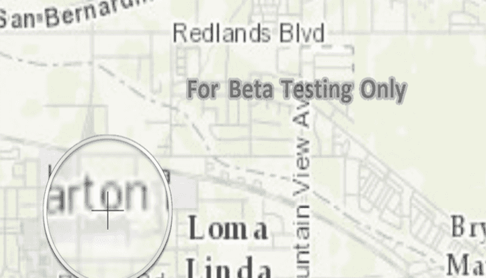
Tap and hold on a map to show a magnifier.
Use case
Due to the limited screen size of some mobile devices, it may be difficult to identify individual features on a map where there is a high density of information, or the scale is very small. This can be the case when a mobile device is used for navigation, and the user wishes to magnify a particular area to better identify a road intersection.
How to use the sample
Tap and hold on the map to show a magnifier, then drag across the map to move the magnifier. You can also pan the map while holding the magnifier, by dragging the magnifier to the edge of the map.
How it works
- Create a new
MapView, and add anArcGISMapto it usingmapView.setMap(map). - Enable the magnifier using
mapView.setMagnifierEnabled(true). This will set the magnifier to be shown on the map when the user performs a long press gesture. Note: The default value isfalse. - Optionally, use
mapView.setCanMagnifierPanMap(true)to allow the map to be panned automatically when the magnifier gets near the edge of the map.
Relevant API
- ArcGISMap
- MapView
- MapView.setCanMagnifierPanMap(...)
- MapView.setMagnifierEnabled(...)
Additional information
This sample only works on a device with a touch screen. The magnifier will not appear via a mouse click.
Tags
magnify, map, zoom
Sample Code
MainActivity.java
/* Copyright 2016 Esri
*
* Licensed under the Apache License, Version 2.0 (the "License");
* you may not use this file except in compliance with the License.
* You may obtain a copy of the License at
*
* http://www.apache.org/licenses/LICENSE-2.0
*
* Unless required by applicable law or agreed to in writing, software
* distributed under the License is distributed on an "AS IS" BASIS,
* WITHOUT WARRANTIES OR CONDITIONS OF ANY KIND, either express or implied.
* See the License for the specific language governing permissions and
* limitations under the License.
*
*/
package com.esri.arcgisruntime.sample.showmagnifier;
import android.os.Bundle;
import androidx.appcompat.app.AppCompatActivity;
import com.esri.arcgisruntime.ArcGISRuntimeEnvironment;
import com.esri.arcgisruntime.mapping.ArcGISMap;
import com.esri.arcgisruntime.mapping.BasemapStyle;
import com.esri.arcgisruntime.mapping.Viewpoint;
import com.esri.arcgisruntime.mapping.view.MapView;
public class MainActivity extends AppCompatActivity {
private MapView mMapView;
@Override
protected void onCreate(Bundle savedInstanceState) {
super.onCreate(savedInstanceState);
setContentView(R.layout.activity_main);
// authentication with an API key or named user is required to access basemaps and other
// location services
ArcGISRuntimeEnvironment.setApiKey(BuildConfig.API_KEY);
// inflate MapView from layout
mMapView = findViewById(R.id.mapView);
// create a map with the Basemap Style topographic
ArcGISMap map = new ArcGISMap(BasemapStyle.ARCGIS_TOPOGRAPHIC);
// set the map to be displayed in this view
mMapView.setMap(map);
mMapView.setViewpoint(new Viewpoint(34.056295, -117.195800, 1000000));
// enable magnifier
mMapView.getInteractionOptions().setMagnifierEnabled(true);
// allow magnifier to pan near the edge of the map bounds
mMapView.getInteractionOptions().setCanMagnifierPanMap(true);
}
@Override
protected void onPause() {
super.onPause();
mMapView.pause();
}
@Override
protected void onResume() {
super.onResume();
mMapView.resume();
}
@Override
protected void onDestroy() {
super.onDestroy();
mMapView.dispose();
}
}