Display local 3D point cloud data.
Use case
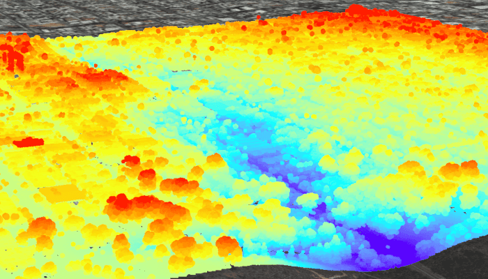
Point clouds are often used to visualize massive sets of sensor data such as lidar. The point locations indicate where the sensor data was measured spatially, and the color or size of the points indicate the measured/derived value of the sensor reading. In the case of lidar, the color of the visualized point could be the color of the reflected light, so that the point cloud forms a true color 3D image of the area.
Point clouds can be loaded offline from scene layer packages (.slpk).
How to use the sample
The sample starts with a point cloud layer loaded and draped on top of a scene. Pan and zoom to explore the scene and see the detail of the point cloud layer.
How it works
- Create a
PointCloudLayerwith the path to a local.slpkfile containing a point cloud layer. - Add the layer to a scene's operational layers collection with
getOperationalLayers().add(pointCloudLayer).
Relevant API
- PointCloudLayer
About the data
This point cloud data comes from Balboa Park in San Diego, California. Created and provided by USGS.
Offline Data
- Download the data from ArcGIS Online.
- Open your command prompt and navigate to the folder where you extracted the contents of the data from step 1.
- Push the data into the scoped storage of the sample app:
adb push sandiego-north-balboa-pointcloud.slpk /Android/data/com.esri.arcgisruntime.sample.viewpointclouddataoffline/files/sandiego-north-balboa-pointcloud.slpk
Tags
3D, lidar, point cloud
Sample Code
/*
* Copyright 2019 Esri
*
* Licensed under the Apache License, Version 2.0 (the "License");
* you may not use this file except in compliance with the License.
* You may obtain a copy of the License at
*
* http://www.apache.org/licenses/LICENSE-2.0
*
* Unless required by applicable law or agreed to in writing, software
* distributed under the License is distributed on an "AS IS" BASIS,
* WITHOUT WARRANTIES OR CONDITIONS OF ANY KIND, either express or implied.
* See the License for the specific language governing permissions and
* limitations under the License.
*/
package com.esri.arcgisruntime.sample.viewpointclouddataoffline;
import android.os.Bundle;
import android.util.Log;
import android.widget.Toast;
import androidx.annotation.Nullable;
import androidx.appcompat.app.AppCompatActivity;
import com.esri.arcgisruntime.ArcGISRuntimeEnvironment;
import com.esri.arcgisruntime.layers.PointCloudLayer;
import com.esri.arcgisruntime.loadable.LoadStatus;
import com.esri.arcgisruntime.mapping.ArcGISScene;
import com.esri.arcgisruntime.mapping.ArcGISTiledElevationSource;
import com.esri.arcgisruntime.mapping.Basemap;
import com.esri.arcgisruntime.mapping.BasemapStyle;
import com.esri.arcgisruntime.mapping.Surface;
import com.esri.arcgisruntime.mapping.view.Camera;
import com.esri.arcgisruntime.mapping.view.SceneView;
public class MainActivity extends AppCompatActivity {
private static final String TAG = MainActivity.class.getSimpleName();
private SceneView mSceneView;
@Override protected void onCreate(@Nullable Bundle savedInstanceState) {
super.onCreate(savedInstanceState);
setContentView(R.layout.activity_main);
// authentication with an API key or named user is required to access basemaps and other
// location services
ArcGISRuntimeEnvironment.setApiKey(BuildConfig.API_KEY);
mSceneView = findViewById(R.id.sceneView);
// create a scene and add it to the scene view
ArcGISScene scene = new ArcGISScene(BasemapStyle.ARCGIS_IMAGERY);
mSceneView.setScene(scene);
// create a camera and initial camera position
Camera camera = new Camera(32.7321157, -117.150072, 452.282774, 25.481533, 78.0945859, 0.0);
// set viewpoint for SceneView using camera
mSceneView.setViewpointCamera(camera);
// set the base surface with world elevation
Surface surface = new Surface();
surface.getElevationSources().add(new ArcGISTiledElevationSource(getString(R.string.elevation_source_url)));
scene.setBaseSurface(surface);
// add a PointCloudLayer to the scene by passing the URI of the scene layer package to the constructor
PointCloudLayer pointCloudLayer = new PointCloudLayer(
getExternalFilesDir(null) + getString(R.string.scene_layer_package_location));
// add the PointCloudLayer to the operational layers of the scene
mSceneView.getScene().getOperationalLayers().add(pointCloudLayer);
// add a listener to perform operations when the load status of the PointCloudLayer changes
pointCloudLayer.addDoneLoadingListener(() -> {
if (pointCloudLayer.getLoadStatus() != LoadStatus.LOADED) {
// notify user that the PointCloudLayer has failed to load
String error = "Point cloud layer failed to load: " + pointCloudLayer.getLoadError().getMessage();
Toast.makeText(this, error, Toast.LENGTH_LONG).show();
Log.e(TAG, error);
}
});
}
@Override protected void onResume() {
super.onResume();
mSceneView.resume();
}
@Override protected void onPause() {
mSceneView.pause();
super.onPause();
}
@Override protected void onDestroy() {
mSceneView.dispose();
super.onDestroy();
}
}