import LineSymbol3DLayer from "@arcgis/core/symbols/LineSymbol3DLayer.js";const LineSymbol3DLayer = await $arcgis.import("@arcgis/core/symbols/LineSymbol3DLayer.js");- Inheritance:
- LineSymbol3DLayer→
Symbol3DLayer→ Accessor
- Since
- ArcGIS Maps SDK for JavaScript 4.0
LineSymbol3DLayer renders Polyline geometries using a flat 2D line with a LineSymbol3D in a 3D SceneView. MapView does not support 3D symbols.
The color of the line is set in the material property. The width of the line may be defined in either points or pixels with the size property. Line width and color can also be data-driven by adding size and/or color visual variables to any Renderer that uses this symbol layer.
A LineSymbol3DLayer must be added to the symbolLayers property of
a LineSymbol3D. Multiple symbol layers may be used in a single
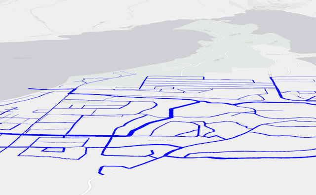
symbol. The image below depicts a line FeatureLayer whose features
are symbolized with a LineSymbol3D containing a LineSymbol3DLayer.
See Symbol3DLayer and Symbol3D to read more general information about 3D symbols, symbol layers and how they relate to one another.
Example
const symbol = { type: "line-3d", // autocasts as new LineSymbol3D() symbolLayers: [{ type: "line", // autocasts as new LineSymbol3DLayer() size: 2, // points material: { color: "black" }, cap: "round", join: "round", pattern: { // autocasts as new LineStylePattern3D() type: "style", style: "dash" }, marker: { // autocasts as new LineStyleMarker3D() type: "style", style: "arrow", placement: "end", color: "red" // black line with red arrows } }]};Constructors
Constructor
Parameters
| Parameter | Type | Description | Required |
|---|---|---|---|
| properties | | |
Properties
cap
- Type
- LineCap
- Since
- ArcGIS Maps SDK for JavaScript 4.12
The style used to draw the endpoint of a line. This also applies to the tips of each pattern segment along the line. See the table below for possible values.
| Possible Value | Example |
|---|---|
| butt | 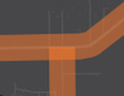 |
| round | 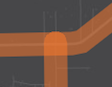 |
| square | 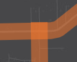 |
- Default value
- "butt"
join
- Type
- LineJoin
- Since
- ArcGIS Maps SDK for JavaScript 4.12
The style used to draw the intersection of two line segments within a line geometry. See the table below for possible values.
| Possible Value | Example |
|---|---|
| bevel | 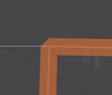 |
| miter | 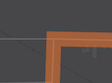 |
| round | 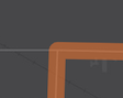 |
- Default value
- "miter"
marker
- Type
- LineStyleMarker3D | null | undefined
- Since
- ArcGIS Maps SDK for JavaScript 4.23
Optional markers to be placed at the start and/or end of each line geometry.
By default, no markers are placed. If markers are added, marker size is proportional to the width of the line. While markers inherit the line's color by default, you can use the color attribute to set a different one.
Example
const symbol = { type: "line-3d", // autocasts as new LineSymbol3D() symbolLayers: [{ type: "line", // autocasts as new LineSymbol3DLayer() material: { color: "black" }, marker: { // autocasts as new LineStyleMarker3D() type: "style", style: "arrow", placement: "end", color: "red" // black line with red arrows } }]}; material
- Type
- Symbol3DMaterial | null | undefined
The material used to shade the line. This property defines the line's color.
Examples
// CSS color stringsymbolLayer.material = { color: "dodgerblue"};// HEX stringsymbolLayer.material = { color: "#33cc33";}// array of RGBA valuessymbolLayer.material = { color: [51, 204, 51, 0.3];}// object with rgba propertiessymbolLayer.material = { color: { r: 51, g: 51, b: 204, a: 0.7 }}; pattern
- Type
- LineStylePattern3D | null | undefined
- Since
- ArcGIS Maps SDK for JavaScript 4.22
The pattern used to render the line stroke. By default, the lines are shown as solid.
Example
const symbol = { type: "line-3d", // autocasts as new LineSymbol3D() symbolLayers: [{ type: "line", // autocasts as new LineSymbol3DLayer() size: 2, // points material: { color: "black" }, pattern: { // autocasts as new LineStylePattern3D() type: "style", style: "dash" } }]}; size
- Type
- number
The width of the line in points. This value may be autocast with a string
expressing size in points or pixels (e.g. 12px).
- Default value
- "1px"
Examples
// width in pointssymbolLayer.size = 4;// width in pixelssymbolLayer.size = "2px";// width in pointssymbolLayer.size = "4pt";Methods
fromJSON
- Signature
-
fromJSON (json: any): any
Creates a new instance of this class and initializes it with values from a JSON object
generated from an ArcGIS product. The object passed into the input json
parameter often comes from a response to a query operation in the REST API or a
toJSON()
method from another ArcGIS product. See the Using fromJSON()
topic in the Guide for details and examples of when and how to use this function.
Parameters
| Parameter | Type | Description | Required |
|---|---|---|---|
| json | A JSON representation of the instance in the ArcGIS format. See the ArcGIS REST API documentation for examples of the structure of various input JSON objects. | |
- Returns
- any
Returns a new instance of this class.
clone
- Signature
-
clone (): LineSymbol3DLayer
Creates a deep clone of the symbol layer.
- Returns
- LineSymbol3DLayer
A deep clone of the object that invoked this method.
Example
// Creates a deep clone of the graphic's first symbol layerlet symLyr = graphic.symbol.symbolLayers.at(0).clone(); toJSON
- Signature
-
toJSON (): any
Converts an instance of this class to its ArcGIS portal JSON representation. See the Using fromJSON() guide topic for more information.
- Returns
- any
The ArcGIS portal JSON representation of an instance of this class.