import MarkerSymbol from "@arcgis/core/symbols/MarkerSymbol.js";const MarkerSymbol = await $arcgis.import("@arcgis/core/symbols/MarkerSymbol.js");- Subclasses:
- PictureMarkerSymbol, SimpleMarkerSymbol
- Since
- ArcGIS Maps SDK for JavaScript 4.0
Marker symbols are used to draw Point graphics in a FeatureLayer or individual graphics in a 2D MapView. To create new marker symbols, use either SimpleMarkerSymbol or PictureMarkerSymbol.
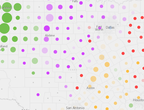
Marker symbols may also be used to symbolize 2D polygon features. The image below depicts a FeatureLayer whose polygon features are styled with SimpleMarkerSymbols.
Marker symbols can be used in a 3D SceneView. However, it is recommended you use PointSymbol3D instead.
- See also
Properties
angle
- Type
- number
The angle of the marker relative to the screen in degrees.
- Default value
- 0
color
The color of the symbol.
This can be autocast with an array of rgb(a) values, named string, hex string or an hsl(a) string,
an object with r, g, b, and a properties, or a Color object.
- Default value
- "black"
Examples
// CSS color stringsymbol.color = "dodgerblue";// HEX stringsymbol.color = "#33cc33";// array of RGBA valuessymbol.color = [51, 204, 51, 0.3];// object with rgba propertiessymbol.color = { r: 51, g: 51, b: 204, a: 0.7}; xoffset
- Type
- number
The offset on the x-axis in points. This value may be autocast with a string
expressing size in points or pixels (e.g. 12px).
- Default value
- 0
Examples
// xoffset in pointssymbol.xoffset = 4;// xoffset in pixelssymbol.xoffset = "2px";// xoffset in pointssymbol.xoffset = "4pt"; yoffset
- Type
- number
The offset on the y-axis in points. This value may be autocast with a string
expressing size in points or pixels (e.g. 12px).
- Default value
- 0
Examples
// yoffset in pointssymbol.yoffset = 4;// yoffset in pixelssymbol.yoffset = "2px";// yoffset in pointssymbol.yoffset = "4pt";Methods
fromJSON
- Signature
-
fromJSON (json: any): any
Creates a new instance of this class and initializes it with values from a JSON object
generated from an ArcGIS product. The object passed into the input json
parameter often comes from a response to a query operation in the REST API or a
toJSON()
method from another ArcGIS product. See the Using fromJSON()
topic in the Guide for details and examples of when and how to use this function.
Parameters
| Parameter | Type | Description | Required |
|---|---|---|---|
| json | A JSON representation of the instance in the ArcGIS format. See the ArcGIS REST API documentation for examples of the structure of various input JSON objects. | |
- Returns
- any
Returns a new instance of this class.
toJSON
- Signature
-
toJSON (): any
Converts an instance of this class to its ArcGIS portal JSON representation. See the Using fromJSON() guide topic for more information.
- Returns
- any
The ArcGIS portal JSON representation of an instance of this class.