import ObjectSymbol3DLayer from "@arcgis/core/symbols/ObjectSymbol3DLayer.js";const ObjectSymbol3DLayer = await $arcgis.import("@arcgis/core/symbols/ObjectSymbol3DLayer.js");- Inheritance:
- ObjectSymbol3DLayer→
Symbol3DLayer→ Accessor
- Since
- ArcGIS Maps SDK for JavaScript 4.0
ObjectSymbol3DLayer is used to render Point geometries using a volumetric 3D shape (e.g., a sphere or cylinder) with a PointSymbol3D in a SceneView. MapView does not support 3D symbols. Polygon features may also be rendered with ObjectSymbol3DLayers, but the object symbol layer must be contained in a PolygonSymbol3D, not a PointSymbol3D in this scenario.
The shape of the object is set in the resource property and the color of the object is set in the material property. The size of the object is always defined in meters. Size can be directly set in the height, width, and depth properties. Object color and size can also be data-driven by adding size and/or color visual variables to any Renderer that uses this symbol layer.
ObjectSymbol3DLayers must be added to the symbolLayers property of
either PointSymbol3D or
PolygonSymbol3D symbols. Multiple symbol layers may be used
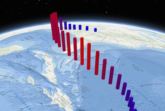
in a single symbol. The image below depicts a point FeatureLayer whose features are
symbolized with a PointSymbol3D containing a cylinder-based
ObjectSymbol3DLayer.
See Symbol3DLayer and Symbol3D to read more general information about 3D symbols, symbol layers and how they relate to one another.
Examples
// symbol using a cylinder as a resourceconst symbol = new PointSymbol3D ({ symbolLayers: [ new ObjectSymbol3DLayer({ width: 5, // diameter of the object from east to west in meters height: 20, // height of the object in meters depth: 15, // diameter of the object from north to south in meters resource: { primitive: "cylinder" }, material: { color: "red" } })]});// symbol using a glTF 3D model as a resourceconst symbol = new PointSymbol3D({ symbolLayers: [ new ObjectSymbol3DLayer({ resource: { href: "../3d-assets/model.gltf" }, height: 3, material: { color: "red" } })]});Constructors
Constructor
Parameters
| Parameter | Type | Description | Required |
|---|---|---|---|
| properties | | |
Properties
| Property | Type | Class |
|---|---|---|
| | ||
| | ||
| | ||
declaredClass readonly inherited | ||
| | ||
| | ||
| | ||
| | ||
| | ||
| | ||
| | ||
type readonly | "object" | |
| |
anchor
- Type
- ObjectSymbol3DLayerAnchor | null | undefined
The positioning of the symbol relative to the geometry. The default behavior (origin) depends on the resource:
- For
sphere,cubeanddiamondprimitives, the origin is at the center. - For
cylinder,cone,inverted-coneandtetrahedronprimitives, the origin is at the bottom. - For
hrefresources, the origin coincides with the origin of the 3D model.
If anchor is set to relative, the anchor is defined by anchorPosition as a fraction of
the symbol's bounding box.
- Default value
- "origin"
anchorPosition
- Type
- Symbol3DAnchorPosition3D | null | undefined
- Since
- ArcGIS Maps SDK for JavaScript 4.10
Defines the anchor relative to the center of the symbol layer resource. It is specified as a
ratio of the resource's bounding box dimensions.
For example, a value of { x: 0, y: 0, z: 0 } designates the center, while a value of { x: -0.5, y: -0.5, z: -0.5 } places
the symbol at the lower south-west corner of the symbol's bounding box.
This property only applies when anchor is set to relative.
Examples
symbolLayer.anchor = "relative";symbolLayer.anchorPosition = { x: 0, y: 0, z: -0.5 }; // equivalent to `anchor: "bottom"`symbolLayer.anchor = "relative";symbolLayer.anchorPosition = { x: 1.5, y: 1, z: 0 }; // the anchor can be placed outside of the symbol's bounding box castShadows
- Type
- boolean
- Since
- ArcGIS Maps SDK for JavaScript 4.11
Indicates whether the symbol layer geometry casts shadows in the scene.
Setting this property to false will disable shadows for the symbol layer
even if direct shadows are enabled in
SceneView.environment.
- Default value
- true
Example
// disables shadow castingsymbolLayer.castShadows = false; heading
The clockwise rotation of the symbol in the horizontal plane (i.e., around the z axis). The rotation is specified in degrees and is relative to the y-axis.
If the symbol resource is aligned such that its forward facing side points in the direction of the y-axis (the y-axis always points North in WGS84 or WebMercator coordinates), its upwards facing side is pointing in the direction of the z-axis, and its right-hand side points in the direction of the x-axis (the x-axis always points East in WGS84 or WebMercator coordinates), then this angle corresponds to the heading of the symbol.
Example
// heading of the symbol in degreessymbolLayer.heading = 180; material
- Type
- Symbol3DMaterial | null | undefined
The material used to shade the object. This property defines the object's color and emissive properties.
Examples
// CSS color stringsymbolLayer.material = { color: "dodgerblue"};// HEX stringsymbolLayer.material = { color: "#33cc33";};// array of RGBA valuessymbolLayer.material = { color: [51, 204, 51, 0.3];};// object with rgba propertiessymbolLayer.material = { color: { r: 51, g: 51, b: 204, a: 0.7 }};// object with emissive properties enabledsymbolLayer.material: { color: "#00E9FF", emissive: { strength: 1, source: "color" },};// object with emissive properties from a object's texturesymbolLayer.material: { emissive: { strength: 1, source: "emissive" },}; resource
- Type
- ObjectSymbol3DLayerResource | null | undefined
The primitive shape (primitive) or external 3D model (href) used to visualize the
points. If both properties are present, primitive takes precedence and href is ignored.
When using the href property, external 3D models must be present in
glTF format.
- Default value
- { primitive: "sphere" }
roll
- Since
- ArcGIS Maps SDK for JavaScript 4.4
The rotation of the symbol in the lateral vertical plane (i.e., around the y axis). The rotation is specified in degrees and is relative to the x-axis. At 0 degrees, the model is level. A positive value lifts the left part and lowers the right part of the model.
If the symbol resource is aligned such that its forward facing side points in the direction of the y-axis (the y-axis always points North in WGS84 or WebMercator coordinates), its upwards facing side is pointing in the direction of the z-axis, and its right-hand side points in the direction of the x-axis (the x-axis always points East in WGS84 or WebMercator coordinates), then this angle corresponds to the roll of the symbol.
Example
// roll of the symbol in degreessymbolLayer.roll = 90; tilt
- Since
- ArcGIS Maps SDK for JavaScript 4.4
The rotation of the symbol in the longitudinal vertical plane (i.e., around the x axis). The rotation is specified in degrees and is relative to the y-axis. At 0 degrees, the model is level. A positive value points lifts the front and lowers the back of the model.
If the symbol resource is aligned such that its forward facing side points in the direction of the y-axis (the y-axis always points North in WGS84 or WebMercator coordinates), its upwards facing side is pointing in the direction of the z-axis, and its right-hand side points in the direction of the x-axis (the x-axis always points East in WGS84 or WebMercator coordinates), then this angle corresponds to the tilt of the symbol.
Example
// tilt of the symbol in degreessymbolLayer.tilt = 45;Methods
fromJSON
- Signature
-
fromJSON (json: any): any
Creates a new instance of this class and initializes it with values from a JSON object
generated from an ArcGIS product. The object passed into the input json
parameter often comes from a response to a query operation in the REST API or a
toJSON()
method from another ArcGIS product. See the Using fromJSON()
topic in the Guide for details and examples of when and how to use this function.
Parameters
| Parameter | Type | Description | Required |
|---|---|---|---|
| json | A JSON representation of the instance in the ArcGIS format. See the ArcGIS REST API documentation for examples of the structure of various input JSON objects. | |
- Returns
- any
Returns a new instance of this class.
clone
- Signature
-
clone (): ObjectSymbol3DLayer
Creates a deep clone of the symbol layer.
- Returns
- ObjectSymbol3DLayer
A deep clone of the object that invoked this method.
Example
// Creates a deep clone of the graphic's first symbol layerlet symLyr = graphic.symbol.symbolLayers.at(0).clone(); toJSON
- Signature
-
toJSON (): any
Converts an instance of this class to its ArcGIS portal JSON representation. See the Using fromJSON() guide topic for more information.
- Returns
- any
The ArcGIS portal JSON representation of an instance of this class.