Learn how to display feature
A pop-up
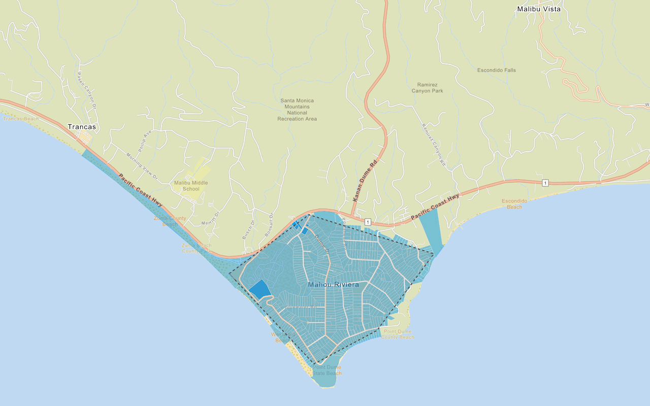
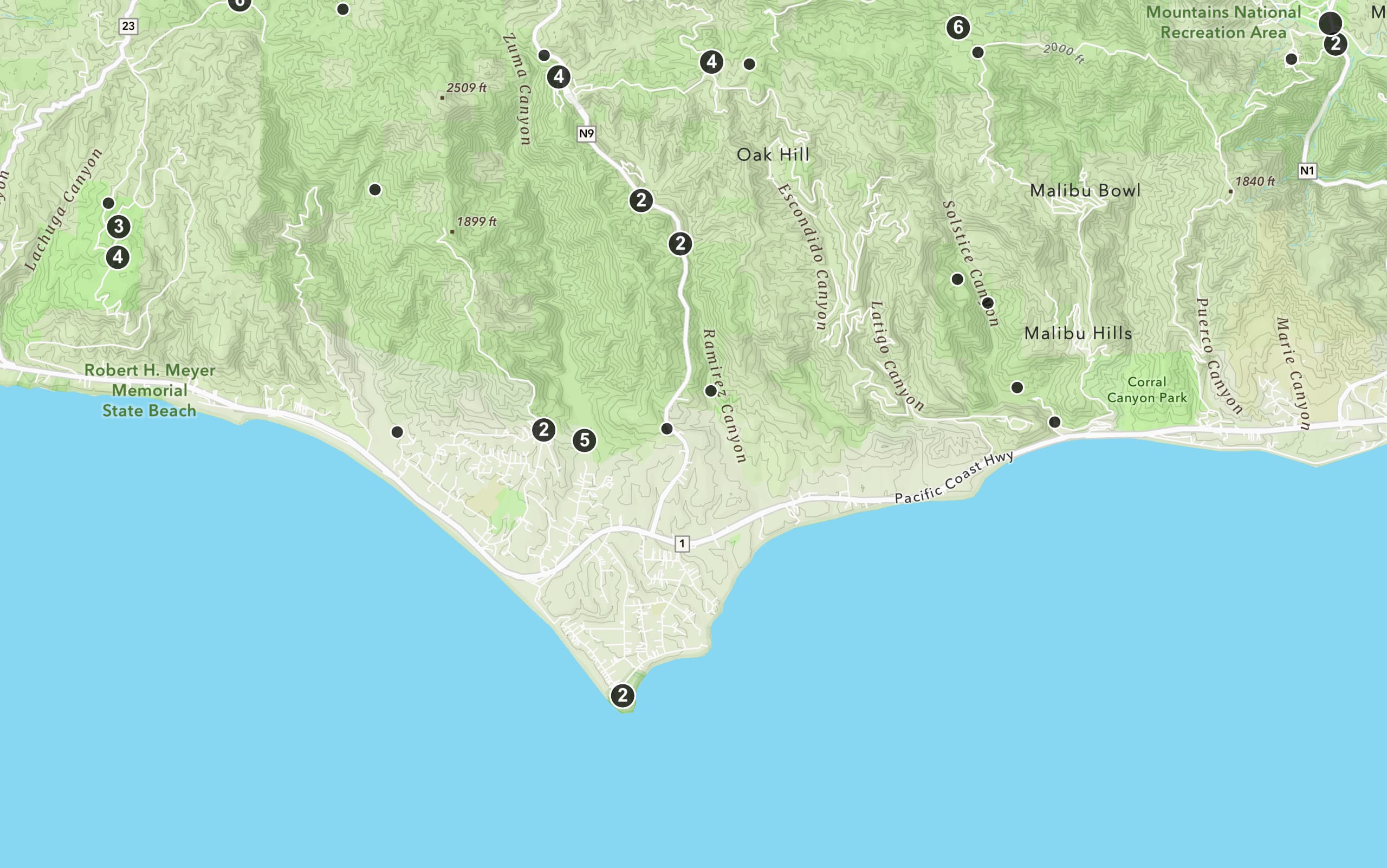
In this tutorial, you create an interactive pop-up for the Trailheads feature layer
Prerequisites
You need an ArcGIS Location Platform or ArcGIS Online account.
Steps
Get the starter app
Select a type of authentication and follow the steps to create a new app.
Choose API key authentication if you:
- Want the easiest way to get started.
- Want to build public applications
A public application is an application that allows anonymous access without requiring users to sign in with an ArcGIS account. It supports API key or app authentication. that access ArcGIS Location ServicesArcGIS Location Services, also referred to as Location Services, are services hosted by Esri that provide geospatial functionality for developing mapping applications. They include the ArcGIS Basemap Styles service, ArcGIS Static Basemap Tiles service, ArcGIS Places service, ArcGIS Geocoding service, ArcGIS Routing service, ArcGIS GeoEnrichment service, and ArcGIS Elevation service. An ArcGIS Location Platform or ArcGIS Online account is required to use the services. and secure itemsAn item, also known as a content item, is a resource stored in a portal such as a web map, hosted layer, style, script tool, file, or notebook. . - Have an ArcGIS Location Platform or ArcGIS Online account.
Choose user authentication if you:
- Want to build private applications.
- Require application users to sign in with their own ArcGIS account
An ArcGIS account is an identity with a user type and set of privileges that can access specific ArcGIS products, tools, APIs, services, and resources. The main account types that can be used for development are an ArcGIS Location Platform account, ArcGIS Online account, and ArcGIS Enterprise account. ArcGIS Location Platform and ArcGIS Online accounts are also associated with a subscription. and access resources their behalf. - Have an ArcGIS Online account.
To learn more about both types of authentication, go to Authentication.
Set up authentication
Set developer credentials
Use the API key or OAuth developer credentials
Add the pop-up library
OpenLayers does not include a pop-up component. You can use the third-party library ol-popup to simplify adding pop-ups to your map.
-
In the
<headelement, add references to the ol-popup library.> Use dark colors for code blocks <link rel="stylesheet" href="https://cdn.jsdelivr.net/npm/ol@v10.9.0/ol.css"> <script src="https://cdn.jsdelivr.net/npm/ol@v10.9.0/dist/ol.js"></script> <script src="https://cdn.jsdelivr.net/npm/ol-mapbox-style@13.4.1/dist/olms.js"></script> <script src="https://unpkg.com/ol-popup@5.1.1/dist/ol-popup.js"></script> <link rel="stylesheet" href="https://unpkg.com/ol-popup@5.1.1/src/ol-popup.css">
Add the trailheads layer
Use a Vector layer with a Vector source to display the trailheads as GeoJSON.
For more information about adding feature layers
-
Before the
olmsinitialization, create a aVectorlayer. Give it aVectorsource with a GeoJSON feature format to load and display the trailheads feature layer. Save it to atrailheadsvariable.Layer Use dark colors for code blocks const basemapId = "arcgis/outdoor"; const trailheadsLayer = new ol.layer.Vector({ source: new ol.source.Vector({ format: new ol.format.GeoJSON(), url: "https://services3.arcgis.com/GVgbJbqm8hXASVYi/arcgis/rest/services/Trailheads/FeatureServer/0/query?where=1%3D1&outFields=*&returnGeometry=true&f=pgeojson", }) }); -
Add the data attribution
Data attribution is the requirement to display the names of data source providers in all applications when accessing ArcGIS content, layers, or services. for the vector tile layer source.- Go to the Trailheads (Santa Monica Mountains) item
An item, also known as a content item, is a resource stored in a portal such as a web map, hosted layer, style, script tool, file, or notebook. . - Scroll down to the Acknowledgments section and copy its value.
- Paste the copied value to the
attributionsproperty.Use dark colors for code blocks const basemapId = "arcgis/outdoor"; const trailheadsLayer = new ol.layer.Vector({ source: new ol.source.Vector({ format: new ol.format.GeoJSON(), url: "https://services3.arcgis.com/GVgbJbqm8hXASVYi/arcgis/rest/services/Trailheads/FeatureServer/0/query?where=1%3D1&outFields=*&returnGeometry=true&f=pgeojson", // Attribution text retrieved from https://arcgis.com/home/item.html?id=883cedb8c9fe4524b64d47666ed234a7 attributions: ["| Los Angeles GeoHub"] }) });
- Go to the Trailheads (Santa Monica Mountains) item
-
Inside
olmsload handler, usemap.addto add this layer to the map.Layer Use dark colors for code blocks olms.apply(map, `https://basemapstyles-api.arcgis.com/arcgis/rest/services/styles/v2/styles/${basemapId}?token=${accessToken}`).then(function (map) { map.addLayer(trailheadsLayer); // Add Esri attribution // Learn more in https://esriurl.com/attribution const source = map.getLayers().item(0).getSource(); const poweredByEsriString = "Powered by <a href='https://www.esri.com/en-us/home' target='_blank'>Esri</a> | "; const attributionFn = source.getAttributions(); if (attributionFn) { source.setAttributions((ViewStateLayerStateExtent) => { return [poweredByEsriString, ...attributionFn(ViewStateLayerStateExtent)]; }); } else source.setAttributions(poweredByEsriString); });
Initialize the pop-up
A Popup is a type of Overlay. Use map.add to add it to the map.
-
Create a new
Popupand save it to apopupvariable. Add it to the map withmap.add.Overlay Use dark colors for code blocks map.addLayer(trailheadsLayer); // Add Esri attribution // Learn more in https://esriurl.com/attribution const source = map.getLayers().item(0).getSource(); const poweredByEsriString = "Powered by <a href='https://www.esri.com/en-us/home' target='_blank'>Esri</a> | "; const attributionFn = source.getAttributions(); if (attributionFn) { source.setAttributions((ViewStateLayerStateExtent) => { return [poweredByEsriString, ...attributionFn(ViewStateLayerStateExtent)]; }); } else source.setAttributions(poweredByEsriString); }); const popup = new Popup(); map.addOverlay(popup);
Display a pop-up on click
A pop-up can display any HTML content. Use a click event handler to detect the click, then use map.get to find any trailhead features at the clicked point. You pass a function as a layer to do so.
If the returned array contains at least one feature, you can use Feature.get to extract the trail name (TRL) and park name (PARK). You then use popup.show to update the pop-up position and content.
-
Add a
clickevent handler. Inside, usegetto get an array of trailhead features clicked on.Features At Pixel Use dark colors for code blocks const popup = new Popup(); map.addOverlay(popup); map.on("click", (event) => { const trailheads = map.getFeaturesAtPixel(event.pixel, { layerFilter: (layer) => layer === trailheadsLayer }); }); -
If there is a trail name to show, use
popup.showto set the position and content of the pop-up. Otherwise, usepopup.hideto hide it.Use dark colors for code blocks const trailheads = map.getFeaturesAtPixel(event.pixel, { layerFilter: (layer) => layer === trailheadsLayer }); if (trailheads.length > 0) { const trailName = trailheads[0].get("TRL_NAME"); const parkName = trailheads[0].get("PARK_NAME"); popup.show(event.coordinate, `<b>${trailName}</b></br>${parkName}`); } else { popup.hide(); }
Run the app
Run the app.
The map view should display the Trailheads feature layerWhat's next?
Learn how to use additional location services in these tutorials:
Query a feature layer (spatial)
Execute a spatial query to access polygon features from a feature service.

Get global data
Query demographic information for locations around the world.

Get local data
Query regional facts and spending trends for a study area in the United States.
Add a feature layer as GeoJSON
Display and style GeoJSON features from a feature service.