
What is a partially offline app?
A partially offline app
There are two scenarios for using partially offline apps:
- Online-first: You download maps and synchronize data in a connected environment before going offline. This strategy is well-suited for a field worker who wants to be prepared for periods of limited or no connectivity.
- Offline-first: You use the app with data you already have locally and access online capabilities when connected to a network, such as using hosted layers
A hosted layer is an item in a portal that contains the properties and settings for a hosted data service or a layer in a hosted data service. .
When do you use partially offline apps?
You use partially offline apps when you have intermittent network access. You will mostly be disconnected, but there will be periods of connectivity during which you can download data for offline use and synchronize offline edits. You can still perform basic mapping tasks offline, as long as you have the map and data downloaded to your device. These tasks include searching for an address, making edits to offline data, performing routing, or using the device's GPU for viewshed, line-of-sight, and interactive distance measurement capabilities.
Mobile data sources for partially offline apps
The mobile data source
- Offline maps: An offline map
An offline map is a map area and its data content downloaded from an offline-enabled web map for use in offline applications built with ArcGIS Maps SDKs for Native Apps. is a map downloaded from a web mapA web map is a map stored as a JSON object that defines properties such as the basemap layer, data layers, layer styles, and pop-up styles. Its JSON structure is defined by the web map specification. . All the layers in the web mapA web map is a map stored as a JSON object that defines properties such as the basemap layer, data layers, layer styles, and pop-up styles. Its JSON structure is defined by the web map specification. have to be offline-enabledOffline-enabled is a setting in a web map or hosted layer item that allows it to be downloaded and used by offline apps. before you can use the map offline. - Offline data: Offline data
Offline data is data that is generated and downloaded from a feature service, vector tile service, or image tile service for use in offline applications built with ArcGIS Maps SDKs for Native Apps. is data that is generated and downloaded from a data serviceData services, also known as hosted data services, are services created dynamically to store and provide access to your data in ArcGIS. Examples are feature services, vector tile services, map tile services, image services, and scene services. . To support offline data, a service must be offline-enabled. - Mobile packages: A mobile package
A mobile package is a stand-alone Mobile Map Package (MMPK) or Mobile Scene Package (MSPK) file for use in offline applications built with ArcGIS Maps SDKs for Native Apps. is an ArcGIS ProArcGIS Pro is a professional desktop GIS application that can explore, visualize, analyze, and manage 2D and 3D data. project containing mapsA map is a collection of layers that are displayed in 2D. It is typically composed of a basemap layer and data layers. and/or scenesA scene is a collection of layers that are displayed in 3D. It is typically composed of a basemap layer, data layers, and 3D data. . - Data files: A data file
A data file is a stand-alone file containing geographic data that can be sideloaded on to a device. It is typically used in offline applications that never connect to a network. is a stand-alone file containing geographic data that can be displayed by a layerA layer is a reference to a collection of geographic data that is used to access and display data. The data for layers are typically provided by the basemap layer service and data services. in a map or scene.
The following table compares the capabilities of different mobile data sources you can use in your partially offline app:
| Offline maps | Offline data | Mobile packages | Data files | |
|---|---|---|---|---|
| 2D maps | 1 | 1 | ||
| 3D scenes | 2 | 2 | ||
| Edit data while offline | 3 | |||
| Synchronize offline edits | 4 | |||
| Fully disconnected apps/devices | 4 | 4 | ||
| Offline geocoding | 5 | |||
| Offline routing | 6 | |||
| Offline analysis | ||||
| Set expiration date for data access |
- 1. Map constructed in code
- 2. Scene constructed in code
- 3. Shapefiles, GeoPackages, and KML
- 4. Custom sideloading workflows required
- 5. Locator exported from ArcGIS Pro
- 6. Network Analysis dataset exported from ArcGIS Pro
Online services in partially offline apps
Partially offline apps can use online services while connected to a network. For example, you can:
- Use an offline map
An offline map is a map area and its data content downloaded from an offline-enabled web map for use in offline applications built with ArcGIS Maps SDKs for Native Apps. , but geocode and find routes using ArcGIS OnlineArcGIS Online is a GIS mapping, analytics, data hosting, and content management software as a service (SaaS) product. It includes applications, tools, APIs, and location services for users and developers. It is subscription-based and requires an ArcGIS Online account. . - Display a web map
A web map is a map stored as a JSON object that defines properties such as the basemap layer, data layers, layer styles, and pop-up styles. Its JSON structure is defined by the web map specification. and add a layerA layer is a reference to a collection of geographic data that is used to access and display data. The data for layers are typically provided by the basemap layer service and data services. from a local shapefileA shapefile is a vector data storage format that contains geometry and attribute data for geographic features. It can also include spatial and non-spatial indexes. . - Configure an offline map
An offline map is a map area and its data content downloaded from an offline-enabled web map for use in offline applications built with ArcGIS Maps SDKs for Native Apps. (or the mapsA map is a collection of layers that are displayed in 2D. It is typically composed of a basemap layer and data layers. or scenesA scene is a collection of layers that are displayed in 3D. It is typically composed of a basemap layer, data layers, and 3D data. in a mobile packageA mobile package is a stand-alone Mobile Map Package (MMPK) or Mobile Scene Package (MSPK) file for use in offline applications built with ArcGIS Maps SDKs for Native Apps. ) to include online layersA layer is a reference to a collection of geographic data that is used to access and display data. The data for layers are typically provided by the basemap layer service and data services. . The content for these layers is not included in the offline map or mobile package. Instead, an online layer will access a data serviceData services, also known as hosted data services, are services created dynamically to store and provide access to your data in ArcGIS. Examples are feature services, vector tile services, map tile services, image services, and scene services. (such as a traffic layer) whenever a network connection is available.
Tutorials

Create an offline-enabled web map
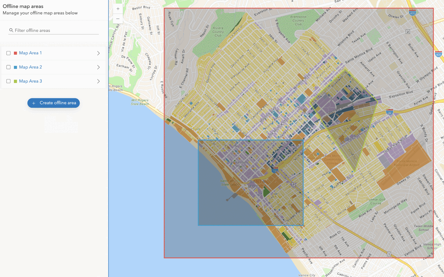
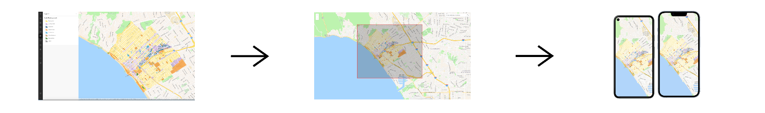
Create an offline map area
Use your portal to create an offline map area from an offline-enabled web map.


Workflows
Create an app using a web map (ahead of time)
Learn how to build an offline app using an offline-enabled web map using the ahead-of-time method.

Create an app using a web map (on-demand)
Learn how to build an offline app using an offline-enabled web map using the on-demand method.

Create an app using a web map with layers (ahead of time)
Learn how to build an offline app using an offline-enabled web map and feature layer using the ahead-of-time method.
Create an app using a web map with layers (on-demand)
Learn how to build an offline app using an offline-enabled web map and feature layer using the on-demand method.

API support
- 1. Manage offline map areas