Learn how to display a map
In this tutorial you will display a fully interactive map
Prerequisites
Before starting this tutorial, you need the following:
-
An ArcGIS Location Platform or ArcGIS Online account.
-
A development and deployment environment that meets the system requirements.
-
An IDE for Android development in Kotlin.
Develop or download
You have two options for completing this tutorial:
Option 1: Develop the code
In this tutorial, you will first code, build, and install the app on a device, and then add the MahouRivieraTrails.mmpk.
Open an Android Studio project
-
Open the project you created by completing the Display a map tutorial.
-
Modify the old project for use in this new tutorial.
-
On your file system, delete the .idea folder, if present, at the top level of your project.
-
In the Android view, open app > res > values > strings.xml.
In the
<string name="app_name">element, change the text content to Display a map from a mobile map package.strings.xml<resources><string name="app_name">Display a map from a mobile map package</string></resources> -
In the Android view, open Gradle Scripts > settings.gradle.kts.
Change the value of
rootProject.nameto “Display a map from a mobile map package”.settings.gradle.kts14 collapsed linespluginManagement {repositories {google {content {includeGroupByRegex("com\\.android.*")includeGroupByRegex("com\\.google.*")includeGroupByRegex("androidx.*")}}mavenCentral()gradlePluginPortal()}}dependencyResolutionManagement {repositoriesMode.set(RepositoriesMode.FAIL_ON_PROJECT_REPOS)repositories {google()mavenCentral()maven { url = uri("https://esri.jfrog.io/artifactory/arcgis") }}}rootProject.name = "Display a map from a mobile map package"include(":app") -
Click File > Sync Project with Gradle files. Android Studio will recognize your changes and create a new .idea folder.
-
Add import statements
-
In the Android view, open app > kotlin+java > com.example.app > MainScreen.kt. Replace the import statements with the imports needed for this tutorial.
MainScreen.kt@file:OptIn(ExperimentalMaterial3Api::class)package com.example.app.screensimport android.content.Contextimport android.widget.Toastimport androidx.compose.foundation.layout.fillMaxSizeimport androidx.compose.foundation.layout.paddingimport androidx.compose.material3.ExperimentalMaterial3Apiimport androidx.compose.material3.Scaffoldimport androidx.compose.material3.Textimport androidx.compose.material3.TopAppBarimport androidx.compose.runtime.Composableimport androidx.compose.runtime.LaunchedEffectimport androidx.compose.runtime.mutableStateOfimport androidx.compose.runtime.rememberimport androidx.compose.ui.Modifierimport androidx.compose.ui.platform.LocalContextimport androidx.compose.ui.res.stringResourceimport com.arcgismaps.mapping.ArcGISMapimport com.arcgismaps.mapping.BasemapStyleimport com.arcgismaps.mapping.MobileMapPackageimport com.arcgismaps.toolkit.geoviewcompose.MapViewimport com.example.app.R
Loading mobile map package and displaying a map
Code the app to select a map from the maps contained in a mobile map package and display the map in a map view. Use the MobileMapPackage class to access the mobile map package and load it to read its contents.
-
In the Android view, open app > res > values > strings.xml. Add a string resource that specifies the file name of the mobile map package.
strings.xml<resources><string name="app_name">Display a map from a mobile map package</string><string name="mahourivieratrails_mmpk">MahouRivieraTrails.mmpk</string></resources> -
In the Android view, open app > kotlin+java > com.example.app > screens > MainScreen.kt. Find the
createMap()function and delete it.MainScreen.kt40 collapsed lines@file:OptIn(ExperimentalMaterial3Api::class)package com.example.app.screensimport androidx.compose.foundation.layout.fillMaxSizeimport androidx.compose.foundation.layout.paddingimport androidx.compose.material3.ExperimentalMaterial3Apiimport androidx.compose.material3.Scaffoldimport androidx.compose.material3.Textimport androidx.compose.material3.TopAppBarimport androidx.compose.runtime.Composableimport androidx.compose.runtime.rememberimport androidx.compose.ui.Modifierimport androidx.compose.ui.res.stringResourceimport com.arcgismaps.mapping.ArcGISMapimport com.arcgismaps.mapping.BasemapStyleimport com.arcgismaps.mapping.Viewpointimport com.arcgismaps.toolkit.geoviewcompose.MapViewimport com.example.app.R@Composablefun MainScreen() {val map = remember {createMap()}Scaffold(topBar = { TopAppBar(title = { Text(text = stringResource(id = R.string.app_name)) }) }) {MapView(modifier = Modifier.fillMaxSize().padding(it),arcGISMap = map)}}fun createMap(): ArcGISMap {return ArcGISMap(BasemapStyle.ArcGISTopographic).apply {initialViewpoint = Viewpoint(latitude = 34.0270,longitude = -118.8050,scale = 72000.0)}} -
Get the local
Contextand assign it to a variable namedcontext. Then specify the file path where the mobile map package will be stored, and assign it to a variable namedmmpkFilePath, which is a string.MainScreen.kt26 collapsed lines@file:OptIn(ExperimentalMaterial3Api::class)package com.example.app.screensimport android.content.Contextimport android.widget.Toastimport androidx.compose.foundation.layout.fillMaxSizeimport androidx.compose.foundation.layout.paddingimport androidx.compose.material3.ExperimentalMaterial3Apiimport androidx.compose.material3.Scaffoldimport androidx.compose.material3.Textimport androidx.compose.material3.TopAppBarimport androidx.compose.runtime.Composableimport androidx.compose.runtime.LaunchedEffectimport androidx.compose.runtime.mutableStateOfimport androidx.compose.runtime.rememberimport androidx.compose.ui.Modifierimport androidx.compose.ui.platform.LocalContextimport androidx.compose.ui.res.stringResourceimport com.arcgismaps.mapping.ArcGISMapimport com.arcgismaps.mapping.BasemapStyleimport com.arcgismaps.mapping.MobileMapPackageimport com.arcgismaps.toolkit.geoviewcompose.MapViewimport com.example.app.Rimport java.io.File@Composablefun MainScreen() {val context = LocalContext.current// Get the path of the mobile map packageval mmpkFilePath = context.getExternalFilesDir(null)?.path + File.separator + stringResource(id = R.string.mahourivieratrails_mmpk)// Create the ArcGIS Map which would use the map provided by the map packageval map = remember {mutableStateOf(ArcGISMap(BasemapStyle.ArcGISTopographic))}Scaffold(topBar = { TopAppBar(title = { Text(text = stringResource(id = R.string.app_name)) }) }) {// Display map when the mobile map package is loadedMapView(modifier = Modifier.fillMaxSize().padding(it),arcGISMap = map.value)}}4 collapsed linesfun showError(context: Context, message: String) {Toast.makeText(context, message, Toast.LENGTH_LONG).show()} -
Inside the
rememberblock, replace thecreateMap()call with a mutable state holding a nullableArcGISMapobject. Then, inMapView, assign themapstate value to thearcGISMapproperty.MainScreen.kt26 collapsed lines@file:OptIn(ExperimentalMaterial3Api::class)package com.example.app.screensimport android.content.Contextimport android.widget.Toastimport androidx.compose.foundation.layout.fillMaxSizeimport androidx.compose.foundation.layout.paddingimport androidx.compose.material3.ExperimentalMaterial3Apiimport androidx.compose.material3.Scaffoldimport androidx.compose.material3.Textimport androidx.compose.material3.TopAppBarimport androidx.compose.runtime.Composableimport androidx.compose.runtime.LaunchedEffectimport androidx.compose.runtime.mutableStateOfimport androidx.compose.runtime.rememberimport androidx.compose.ui.Modifierimport androidx.compose.ui.platform.LocalContextimport androidx.compose.ui.res.stringResourceimport com.arcgismaps.mapping.ArcGISMapimport com.arcgismaps.mapping.BasemapStyleimport com.arcgismaps.mapping.MobileMapPackageimport com.arcgismaps.toolkit.geoviewcompose.MapViewimport com.example.app.Rimport java.io.File@Composablefun MainScreen() {val context = LocalContext.current// Get the path of the mobile map packageval mmpkFilePath = context.getExternalFilesDir(null)?.path + File.separator + stringResource(id = R.string.mahourivieratrails_mmpk)// Create the ArcGIS Map which would use the map provided by the map packageval map = remember {mutableStateOf(ArcGISMap(BasemapStyle.ArcGISTopographic))}Scaffold(topBar = { TopAppBar(title = { Text(text = stringResource(id = R.string.app_name)) }) }) {// Display map when the mobile map package is loadedMapView(modifier = Modifier.fillMaxSize().padding(it),arcGISMap = map.value)}}4 collapsed linesfun showError(context: Context, message: String) {Toast.makeText(context, message, Toast.LENGTH_LONG).show()} -
Call the
LaunchedEffectcomposable. In theLaunchedEffectblock, load the mobile map package.If the mobile map package loaded successfully, get the first map stored in the mobile map package and assign it to the map state value. If the mobile map package failed to load, create a top-level
showError()function and call it.MainScreen.kt26 collapsed lines@file:OptIn(ExperimentalMaterial3Api::class)package com.example.app.screensimport android.content.Contextimport android.widget.Toastimport androidx.compose.foundation.layout.fillMaxSizeimport androidx.compose.foundation.layout.paddingimport androidx.compose.material3.ExperimentalMaterial3Apiimport androidx.compose.material3.Scaffoldimport androidx.compose.material3.Textimport androidx.compose.material3.TopAppBarimport androidx.compose.runtime.Composableimport androidx.compose.runtime.LaunchedEffectimport androidx.compose.runtime.mutableStateOfimport androidx.compose.runtime.rememberimport androidx.compose.ui.Modifierimport androidx.compose.ui.platform.LocalContextimport androidx.compose.ui.res.stringResourceimport com.arcgismaps.mapping.ArcGISMapimport com.arcgismaps.mapping.BasemapStyleimport com.arcgismaps.mapping.MobileMapPackageimport com.arcgismaps.toolkit.geoviewcompose.MapViewimport com.example.app.Rimport java.io.File@Composablefun MainScreen() {val context = LocalContext.current// Get the path of the mobile map packageval mmpkFilePath = context.getExternalFilesDir(null)?.path + File.separator + stringResource(id = R.string.mahourivieratrails_mmpk)// Create the ArcGIS Map which would use the map provided by the map packageval map = remember {mutableStateOf(ArcGISMap(BasemapStyle.ArcGISTopographic))}LaunchedEffect(Unit) {// Load the mobile map packageval mapPackage = MobileMapPackage(mmpkFilePath)mapPackage.load().onSuccess {map.value = mapPackage.maps.first()}.onFailure { error ->showError(context, "Failed to load mobile map package: ${error.message}")}}Scaffold(topBar = { TopAppBar(title = { Text(text = stringResource(id = R.string.app_name)) }) }) {// Display map when the mobile map package is loadedMapView(modifier = Modifier.fillMaxSize().padding(it),arcGISMap = map.value)}}fun showError(context: Context, message: String) {Toast.makeText(context, message, Toast.LENGTH_LONG).show()}
Build and install your app
This is a necessary step, because the app install process creates the path (sdcard > Android > data > com.example.app > files) where you will upload your mobile map package to the device. Do not try to create the path manually in Device Explorer, as you will get a Operation not permitted error.
-
Click Run > Run > app to run the app.
In Android Studio, you have two choices for running your app: an actual Android device or the Android Emulator.
Android device
Connect your computer to your Android device, using USB or Wi-Fi. For more details, see How to connect your Android device.
Android Emulator
Create an AVD (Android Virtual Device) to run in the Android Emulator. For details, see Run apps on the Android Emulator.
Selecting a device
When you build and run an app in Android Studio, you must first select a device. From the Android Studio toolbar, you can access the drop-down list of your currently available devices, both virtual and physical.
 .
.If you cannot access the list on the toolbar, click Tools > Device Manager.
Your app will be built and installed on the Android Virtual Device (AVD) that is currently selected in the Android Studio toolbar. On the AVD, you should see an
ArcGISTopographicmap with initial extent of the whole world. You should also see the app name Display a map from a mobile map package at the top of the screen, and the message Failed to load mobile map package: File not found. briefly displayed at the bottom. This is expected.Next you will add the mobile map package.
Add a mobile map package using Device Explorer
Add a mobile map package (.mmpk) to the device file system for use by your app.
-
On your development computer, create or download the
MahouRivieraTrails.mmpkmobile map package. Either complete the Create a mobile map package tutorial to create the package yourself, or download theMahouRivieraTrails.mmpkmobile map package from ArcGIS Online. -
In Android Studio, verify that your Android Virtual Device (AVD) is still connected. If it is not, expand More info below.
If you already closed the AVD on which you installed your app, then launch the Android Emulator manually.
- Click Tools > Device Manager. In the Device Manager, click the triangle icon (Start button) on the AVD you used before.
-
Display the Device Explorer tool window, which shows the file system on your AVD. Click View > Tool Windows > Device Explorer and wait until Device Manager connects to your AVD and shows the file system tree.
-
Upload the MahouRivieraTrails.mmpk file from your development computer.
-
In Device Explorer, right-click on the sdcard > Android > data directory and click Synchronize.
-
Right-click on sdcard > Android > data > com.example.app > files and click Upload. Navigate to the MahouRivieraTrails.mmpk file on your development computer. Then click OK.
You should see a Device Explorer Toast in the lower corner confirming success.
-
-
Restart the app on your AVD.
-
Shut down the app running on your AVD. Clicking Run > Stop ‘app’ in Android Studio is the quickest way to stop the app.
-
Run the app a second time by clicking Run > Run > app.
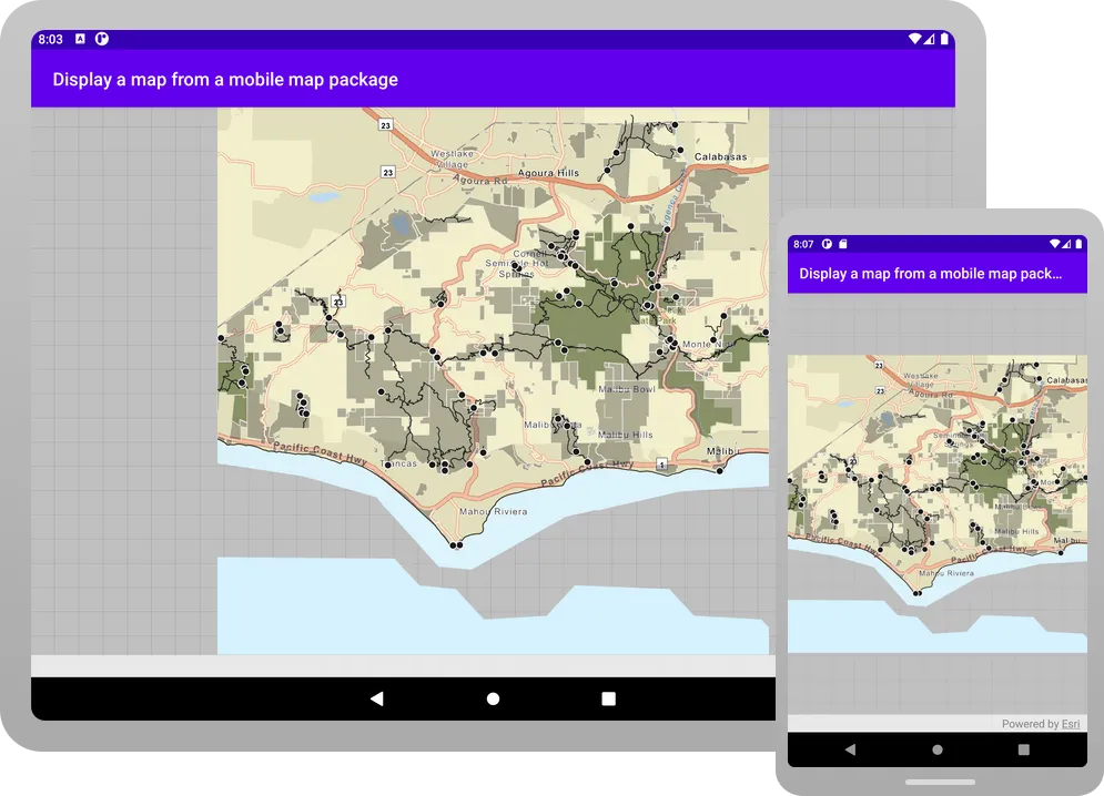
You will see a map
A map is a collection of layers that are displayed in 2D. It is typically composed of a basemap layer and data layers. of trailheads, trails, and parks for the area south of the Santa Monica mountains. You can pinch (to zoom and rotate), drag, and double-tap the map view to explore the map.
-
Alternatively, you can download the tutorial solution, as follows.
Option 2: Download the solution
-
Click the Download solution link in the right-hand side of this page.
-
Unzip the file to a location on your machine.
-
Run Android Studio.
-
Go to File > Open…. Navigate to the solution folder and click Open.
On Windows: If you are in the Welcome to Android Studio dialog, click Open and navigate to the solution folder. Then click Open.
Run the app
- Follow the steps in the Add a mobile map package using Device Explorer section above. Those instructions apply to both the Develop the code and Download the solution workflows.
What’s next?
Learn how to use additional API features, ArcGIS location services, and ArcGIS tools in these tutorials: