Learn how to add multiple basemap layers from different services to your map.
This tutorial shows how to display two basemap layers from different services in your application. You will use the World Imagery map tile service satellite imagery basemap to provide the underlying visual and geographic context for the map. To provide additional context, you will use the arcgis/imagery/labels style from the ArcGIS Static Basemap Tiles service to display place labels for the world. The combination of the two layers will result in a basemap that provides additional context for the mapping application.
Prerequisites
You need an ArcGIS Location Platform account.
ArcGIS Online and ArcGIS Enterprise accounts are not supported.
Steps
Get the starter app
Select a type of authentication and follow the steps to create a new app.
Choose API key authentication if you:
- Want the easiest way to get started.
- Want to build public applications that access ArcGIS Location Services and secure items.
- Have an ArcGIS Location Platform or ArcGIS Online account.
Choose user authentication if you:
- Want to build private applications.
- Require application users to sign in with their own ArcGIS account and access resources their behalf.
- Have an ArcGIS Online account.
To learn more about both types of authentication, go to Authentication.
Set up authentication
Set developer credentials
Use the API key or OAuth developer credentials so your application can access ArcGIS services.
Update the map's viewpoint
-
Remove the basemap and attribution code from the starter tutorial for now. You will add them back later.
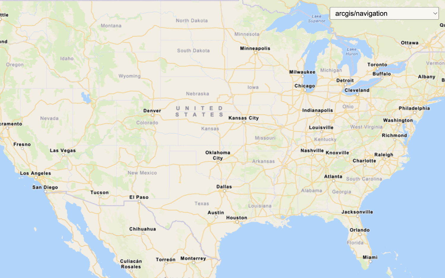
Use dark colors for code blocks <script> /* Use for API key authentication */ const accessToken = "YOUR_ACCESS_TOKEN"; const basemapId = "arcgis/navigation"; const basemapURL = "https://static-map-tiles-api.arcgis.com/arcgis/rest/services/static-basemap-tiles-service/v1"; const tileLayer = new ol.layer.Tile({ source: new ol.source.XYZ({ url: `${basemapURL}/${basemapId}/static/tile/{z}/{y}/{x}?token=${accessToken}`, // Default basemap tileSize: 512 }) }); const map = new ol.Map({ target: "map", layers: [tileLayer], view: new ol.View({ center: ol.proj.fromLonLat([-20, 30]), zoom: 3 }) }); fetch(`${basemapURL}/${basemapId}/static?token=${accessToken}`) .then((response) => response.json()) .then((data) => { tileLayer .getSource() .setAttributions("Powered by <a href='https://www.esri.com/en-us/home' target='_blank'>Esri</a> | " + [data.copyrightText]); }); </script> -
Change the map's center to
[-91.2996, 37.1174]and zoom level to5. This will focus the map on the United States of America.Use dark colors for code blocks Copy const map = new ol.Map({ target: "map", view: new ol.View({ center: ol.proj.fromLonLat([-91.2996, 37.1174]), // USA (x, y) zoom: 5 }) });
Add basemap layer 1
Use the XYZ and Tile classes to access and display basemap layer from the World Imagery map tile service.
-
Create an
XYZsource using thexyzURL for the map tile layer.Use dark colors for code blocks const tile = new ol.source.XYZ({ url: `https://ibasemaps-api.arcgis.com/arcgis/rest/services/World_Imagery/MapServer/tile/{z}/{y}/{x}?token=${accessToken}`, }); -
Create a
Tilelayer using theXYZsource.Use dark colors for code blocks const tile = new ol.source.XYZ({ url: `https://ibasemaps-api.arcgis.com/arcgis/rest/services/World_Imagery/MapServer/tile/{z}/{y}/{x}?token=${accessToken}`, }); const tileLayer = new ol.layer.Tile({ source: tile }); -
Add the data attribution for the map tile layer source.
- Go to the World Imagery item.
- Scroll down to the Acknowledgments section and copy its value.
- Paste the copied value to the
attributionsproperty.Use dark colors for code blocks const tile = new ol.source.XYZ({ url: `https://ibasemaps-api.arcgis.com/arcgis/rest/services/World_Imagery/MapServer/tile/{z}/{y}/{x}?token=${accessToken}`, attributions: ["Esri, Maxar, Earthstar Geographics, and the GIS User Community | "] // Attribution text retrieved from https://nation.maps.arcgis.com/home/item.html?id=d27a3805595e4bb598678f2dc3b1fca3 }); const tileLayer = new ol.layer.Tile({ source: tile });
Add basemap layer 2
In this step, you add another basemap layer from the Static Basemap Tiles service to provide place labels.
-
Set
basemaptoId arcgis/imagery/labelsandbasemapto the Static Basemap Tiles service endpoint.URL Use dark colors for code blocks const basemapId = "arcgis/imagery/labels"; const basemapURL = "https://static-map-tiles-api.arcgis.com/arcgis/rest/services/static-basemap-tiles-service/v1"; -
Create a
Tilelayer for the static basemap tiles using theXYZsource.Use dark colors for code blocks const basemapId = "arcgis/imagery/labels"; const basemapURL = "https://static-map-tiles-api.arcgis.com/arcgis/rest/services/static-basemap-tiles-service/v1"; const staticBasemapTileLayer = new ol.layer.Tile({ source: new ol.source.XYZ({ url: `${basemapURL}/${basemapId}/static/tile/{z}/{y}/{x}?token=${accessToken}`, // Default basemap tileSize: 512, attributions: [ "Powered by <a href='https://www.esri.com/en-us/home' target='_blank'>Esri</a> | Sources: Esri, TomTom, Garmin, FAO, NOAA, USGS, © OpenStreetMap contributors, and the GIS User Community" ] }) }); -
Add both
tileandLayer staticto the map.Basemap Tile Layer Use dark colors for code blocks const map = new ol.Map({ target: "map", layers: [tileLayer, staticBasemapTileLayer], view: new ol.View({ center: ol.proj.fromLonLat([-91.2996, 37.1174]), // USA (x, y) zoom: 5 }) });
Run the app
Run the app.
The map should display basemap layers from the World Imagery map tile service and the Static Basemap Tiles service.What's next?
Learn how to use additional location services in these tutorials: