Apply an RGB renderer to a raster layer to enhance feature visibility.
Use case
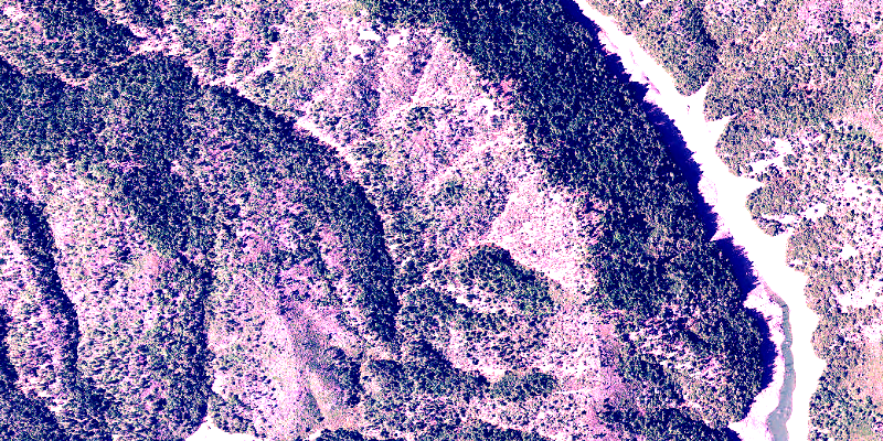
An RGB renderer is used to adjust the color bands of a multispectral image. Remote sensing images acquired from satellites often contain values representing the reflection of multiple spectrums of light. Changing the RGB renderer of such rasters can be used to differentiate and highlight particular features that reflect light differently, such as different vegetation types, or turbidity in water.
How to use the sample
Choose one of the stretch parameter types. The other options will adjust based on the chosen type. Add your inputs and click the ‘Update’ button to update the renderer.
How it works
- Create a
Rasterfrom a multispectral raster file. - Create a
RasterLayerfrom the raster. - Create a
Basemapfrom the raster layer and instantiate an ArcGISMap with it. - Create a
RGBRenderer, specifying theStretchParametersand other properties. - Set the renderer on the raster layer with
rasterLayer.setRasterRenderer(renderer).
Relevant API
- Basemap
- Raster
- RasterLayer
- RGBRenderer
- StretchParameters
About the data
The raster used in this sample shows an area in the south of the Shasta-Trinity National Forest, California.
Tags
analysis, color, composite, imagery, multiband, multispectral, pan-sharpen, photograph, raster, spectrum, stretch, visualization
Sample Code
/* * Copyright 2022 Esri. * * Licensed under the Apache License, Version 2.0 (the "License"); * you may not use this file except in compliance with the License. * You may obtain a copy of the License at * * http://www.apache.org/licenses/LICENSE-2.0 * * Unless required by applicable law or agreed to in writing, software * distributed under the License is distributed on an "AS IS" BASIS, * WITHOUT WARRANTIES OR CONDITIONS OF ANY KIND, either express or implied. * See the License for the specific language governing permissions and * limitations under the License. */
module com.esri.samples.rgb_renderer {  // require ArcGIS Maps SDK for Java module  requires com.esri.arcgisruntime;
  // handle SLF4J http://www.slf4j.org/codes.html#StaticLoggerBinder  requires org.slf4j.nop;
  // require JavaFX modules that the application uses  requires javafx.graphics;  requires javafx.controls;  requires javafx.fxml;
  // make all @FXML annotated objects reflectively accessible to the javafx.fxml module  opens com.esri.samples.rgb_renderer to javafx.fxml;
  exports com.esri.samples.rgb_renderer;}
/* * Copyright 2017 Esri. * * Licensed under the Apache License, Version 2.0 (the "License"); you may not * use this file except in compliance with the License. You may obtain a copy of * the License at * * http://www.apache.org/licenses/LICENSE-2.0 * * Unless required by applicable law or agreed to in writing, software * distributed under the License is distributed on an "AS IS" BASIS, WITHOUT * WARRANTIES OR CONDITIONS OF ANY KIND, either express or implied. See the * License for the specific language governing permissions and limitations under * the License. */
package com.esri.samples.rgb_renderer;
import java.io.File;import java.util.Arrays;import java.util.List;
import javafx.fxml.FXML;import javafx.scene.control.ComboBox;import javafx.scene.control.Spinner;import javafx.scene.layout.GridPane;import javafx.scene.layout.HBox;import javafx.scene.layout.VBox;
import com.esri.arcgisruntime.layers.RasterLayer;import com.esri.arcgisruntime.mapping.ArcGISMap;import com.esri.arcgisruntime.mapping.Basemap;import com.esri.arcgisruntime.mapping.view.MapView;import com.esri.arcgisruntime.raster.MinMaxStretchParameters;import com.esri.arcgisruntime.raster.PercentClipStretchParameters;import com.esri.arcgisruntime.raster.RGBRenderer;import com.esri.arcgisruntime.raster.Raster;import com.esri.arcgisruntime.raster.StandardDeviationStretchParameters;import com.esri.arcgisruntime.raster.StretchParameters;
public class RgbRendererController {
@FXML private HBox stdDeviationGroup; @FXML private GridPane minMaxGroup; @FXML private VBox percentClipGroup; @FXML private MapView mapView; @FXML private ComboBox<String> stretchTypeComboBox; @FXML private Spinner<Integer> factorSpinner; @FXML private Spinner<Integer> minPercentSpinner; @FXML private Spinner<Integer> maxPercentSpinner; @FXML private Spinner<Integer> minRedSpinner; @FXML private Spinner<Integer> minGreenSpinner; @FXML private Spinner<Integer> minBlueSpinner; @FXML private Spinner<Integer> maxRedSpinner; @FXML private Spinner<Integer> maxGreenSpinner; @FXML private Spinner<Integer> maxBlueSpinner;
private RasterLayer rasterLayer;
public void initialize() {
// create raster Raster raster = new Raster(new File(System.getProperty("data.dir"), "./samples-data/raster/Shasta.tif").getAbsolutePath());
// create a raster layer rasterLayer = new RasterLayer(raster);
// create a basemap from the raster layer Basemap basemap = new Basemap(rasterLayer); ArcGISMap map = new ArcGISMap(basemap);
// set the map to the map view mapView.setMap(map);
// set stretch types stretchTypeComboBox.getItems().addAll("Min Max", "Percent Clip", "Std Deviation");
// hide options based on selected stretch type stretchTypeComboBox.getSelectionModel().selectedItemProperty().addListener(e -> { String type = stretchTypeComboBox.getSelectionModel().getSelectedItem(); minMaxGroup.setVisible("Min Max".equals(type)); percentClipGroup.setVisible("Percent Clip".equals(type)); stdDeviationGroup.setVisible("Std Deviation".equals(type)); });
// set up sliders to match constraint min + max <= 100 minPercentSpinner.valueProperty().addListener(e -> { if (minPercentSpinner.getValue() + maxPercentSpinner.getValue() > 100) { maxPercentSpinner.getValueFactory().setValue(100 - minPercentSpinner.getValue()); } }); maxPercentSpinner.valueProperty().addListener(e -> { if (minPercentSpinner.getValue() + maxPercentSpinner.getValue() > 100) { minPercentSpinner.getValueFactory().setValue(100 - maxPercentSpinner.getValue()); } });
stretchTypeComboBox.getSelectionModel().select(0);
updateRenderer(); }
/** * Updates the raster layer renderer according to the chosen property values. */ public void updateRenderer() {
StretchParameters stretchParameters; switch (stretchTypeComboBox.getSelectionModel().getSelectedItem()) { case "Min Max": List<Double> minValues = Arrays.asList(minRedSpinner.getValue().doubleValue(), minGreenSpinner.getValue() .doubleValue(), minBlueSpinner.getValue().doubleValue()); List<Double> maxValues = Arrays.asList(maxRedSpinner.getValue().doubleValue(), maxGreenSpinner.getValue() .doubleValue(), maxBlueSpinner.getValue().doubleValue()); stretchParameters = new MinMaxStretchParameters(minValues, maxValues); break; case "Percent Clip": stretchParameters = new PercentClipStretchParameters(minPercentSpinner.getValue(), maxPercentSpinner.getValue()); break; default: stretchParameters = new StandardDeviationStretchParameters(factorSpinner.getValue()); }
// create rgb renderer RGBRenderer rgbRenderer = new RGBRenderer(stretchParameters, Arrays.asList(0, 1, 2), null, true);
rasterLayer.setRasterRenderer(rgbRenderer); }
/** * Stops and releases all resources used in application. */ void terminate() {
if (mapView != null) { mapView.dispose(); } }
}/* * Copyright 2017 Esri. * * Licensed under the Apache License, Version 2.0 (the "License"); you may not * use this file except in compliance with the License. You may obtain a copy of * the License at * * http://www.apache.org/licenses/LICENSE-2.0 * * Unless required by applicable law or agreed to in writing, software * distributed under the License is distributed on an "AS IS" BASIS, WITHOUT * WARRANTIES OR CONDITIONS OF ANY KIND, either express or implied. See the * License for the specific language governing permissions and limitations under * the License. */
package com.esri.samples.rgb_renderer;
import java.io.IOException;
import javafx.application.Application;import javafx.fxml.FXMLLoader;import javafx.scene.Parent;import javafx.scene.Scene;import javafx.stage.Stage;
public class RgbRendererSample extends Application {
private static RgbRendererController controller;
@Override public void start(Stage stage) throws IOException { // set up the scene FXMLLoader loader = new FXMLLoader(getClass().getResource("/rgb_renderer/main.fxml")); Parent root = loader.load(); controller = loader.getController(); Scene scene = new Scene(root);
// set up the stage stage.setTitle("Rgb Renderer Sample"); stage.setWidth(800); stage.setHeight(700); stage.setScene(scene); stage.show(); }
/** * Stops and releases all resources used in application. */ @Override public void stop() { controller.terminate(); }
/** * Opens and runs application. * * @param args arguments passed to this application */ public static void main(String[] args) {
Application.launch(args); }}