1. Sign up for an account
Create an account to generate developer credentials, access development tools, and monitor usage of ArcGIS services.
ArcGIS Location Platform
- For individual developers.
- Build public applications that don't require users to sign in with an ArcGIS account.
- Build commercial applications that generate revenue.
- Use free monthly tiers and pay-as-you-go to access location services and host your data. For details, see Pricing.
ArcGIS Online
- For developers in an organization.
- Build applications that are:
- Private for your organization that requires users to sign in with their ArcGIS account.
- Public that don't require users to sign in.
- Build low-code/no-code applications with app builders.
- Use credits yearly to access location services and host your data. For details, see Understanding credits.
2. Get an access token
To access ArcGIS resources and services, you'll need an access token. The easiest way is to use API key authentication.
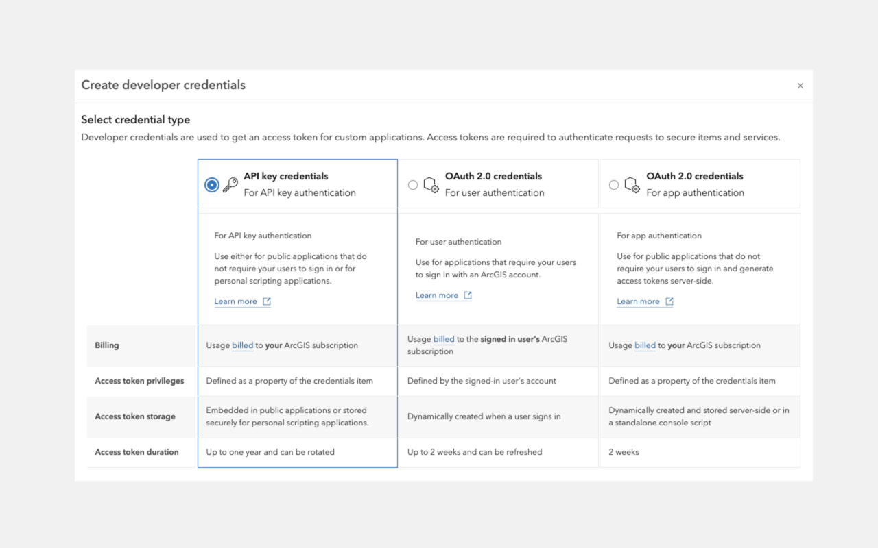
Learn more about the types of authentication and access tokens.
3. Display your first scene
This example displays the satellite imagery style from the ArcGIS Basemap Styles service.
- Open the code in or your preferred code editor.
- Replace
YOURwith your access token._ACCESS _TOKEN
For detailed step-by-step instructions, go to the Display a scene tutorial.
<body>
<div id="cesiumContainer"></div>
<script>
const accessToken = "YOUR_ACCESS_TOKEN";
Cesium.ArcGisMapService.defaultAccessToken = accessToken;
const cesiumAccessToken = "YOUR_CESIUM_ACCESS_TOKEN";
Cesium.Ion.defaultAccessToken = cesiumAccessToken;
const viewer = new Cesium.Viewer("cesiumContainer", {
baseLayer: Cesium.ImageryLayer.fromProviderAsync(
Cesium.ArcGisMapServerImageryProvider.fromBasemapType(Cesium.ArcGisBaseMapType.SATELLITE, {
enablePickFeatures: false
})),
});
viewer.camera.setView({
destination: Cesium.Cartesian3.fromDegrees(25, 30, 2000000),
orientation: {
heading: Cesium.Math.toRadians(0.0),
pitch: Cesium.Math.toRadians(-50.0)
}
});
// Add Esri attribution
// Learn more in https://esriurl.com/attribution
const poweredByEsri = new Cesium.Credit("Powered by <a href='https://www.esri.com/en-us/home' target='_blank'>Esri</a>", true);
viewer.creditDisplay.addStaticCredit(poweredByEsri);
</script>
</body>
4. What's next?
Learn more about displaying maps, hosting your data as services, and accessing additional ArcGIS services.
Scenes
Display scenes with ArcGIS base layers.
Data services
Access and display hosted feature layers, scene layers, and map tiles.
Geocoding
Find addresses and get suggestions with the ArcGIS Geocoding service.
Routing
Find routes and directions and perform analyses with the ArcGIS Routing service.
Places
Search for places near a location with the ArcGIS Places service.
Data enrichment
Get local facts and demographic data with the ArcGIS GeoEnrichment service.
Elevation
Get elevation value of a location with the ArcGIS Elevation service.
Spatial analysis
Perform feature analysis with the Spatial analysis services.