Tutorial: Search for an address

Learn how to find an address or place using a search box and the geocoding service.
Search for an address

Find the location of addresses with the geocoding service.

Geocoding is the process of converting address or place text to a location. The geocoding service provides address and place geocoding and reverse geocoding.

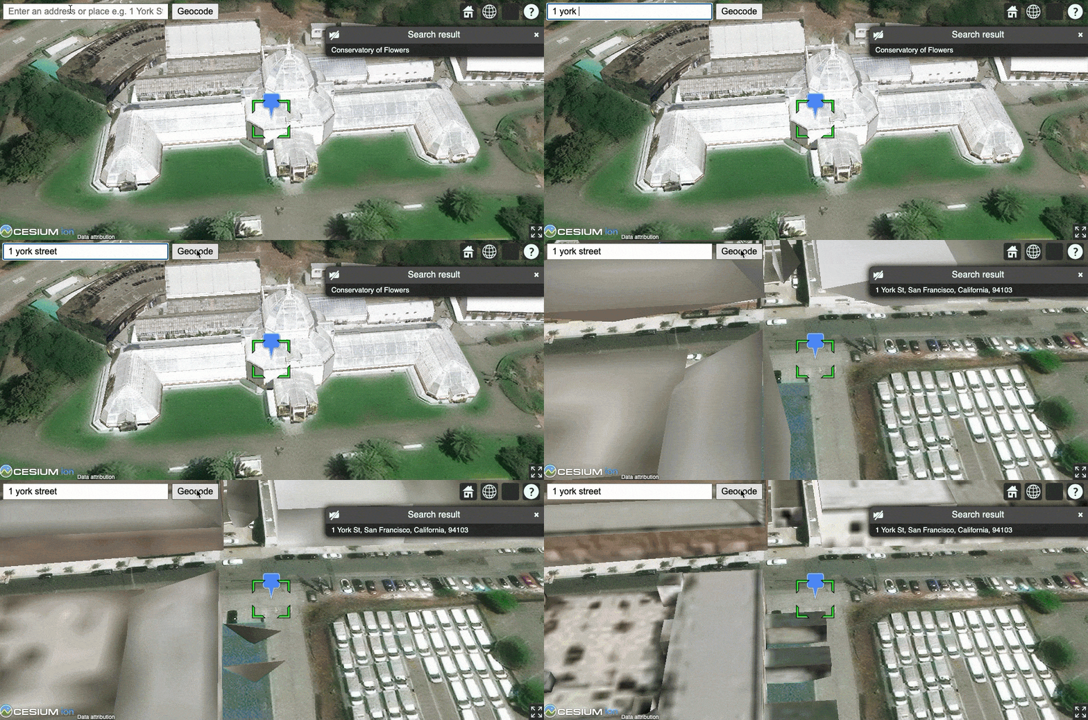
In this tutorial, you use ArcGIS REST JS to access the geocoding service. You use a simple input control to accept text and a button to execute a search for an address or place. When an address or place is located, a pop-up will appear with the name, location, and address, and the view will pan to it.

Prerequisites

You need an ArcGIS Developer or ArcGIS Online account to access the developer dashboard and create an API key.

Steps

Create a new pen

  1. To get started, either complete the Display a scene tutorial or .

Set the API key

To access location services, you need an API key or OAuth 2.0 access token. To learn how to create and scope your key, visit the Create an API key tutorial.

  1. Go to your dashboard to get an API key. The API key must be scoped to access the services used in this tutorial.

  2. In CodePen, update apiKey to use your key. Update cesiumAccessToken to use your Cesium ion access token.

    Use dark colors for code blocks
    1
    2
    3
    4
    5
    6
    7
    8
    9
    10
    11
    12
    13
    14
    15
    16
    17
    18
    19
    20
    21
    22
    23
    24
    25
    26
    27
    28
    29
    30
    31
    32
    33
    34
    35
    36
    37
    38
    39
    40
    41
    42
    43
    44
    45
    46
    47
    48
    49
    50
    51
    52
    53
    54
    55
    56
    57
    58
    59
          const apiKey = "YOUR_API_KEY";
    
          Cesium.ArcGisMapService.defaultAccessToken = apiKey;
    
          const cesiumAccessToken = "YOUR_CESIUM_ACCESS_TOKEN";
    
          Cesium.Ion.defaultAccessToken = cesiumAccessToken;
    
          const arcGisImagery = Cesium.ArcGisMapServerImageryProvider.fromBasemapType(Cesium.ArcGisBaseMapType.SATELLITE);
    
          const viewer = new Cesium.Viewer("cesiumContainer", {
    
            baseLayer: Cesium.ImageryLayer.fromProviderAsync(arcGisImagery),
    
          });
    

Add references to ArcGIS REST JS

  1. In the <head> element, reference the geocoding and request packages from ArcGIS REST JS.

    Expand
    Use dark colors for code blocks
    1
    2
    3
    4
    5
    6
    7
    8
    9
    10
    11
    12
    13
    14
    15
    16
    17
    18
    19
    20
    21
    22
    23
    24
    25
    26
    27
    28
    29
    30
    31
    32
    33
    34
    35
    36
    37
    38
    39
    40
    41
    42
    43
    44
    45
    46
    47
    48
    49
    50
    51
    52
    53
    54
    55
    56
    57
    58
    59
    60
    61
    62
        <script src="https://cesium.com/downloads/cesiumjs/releases/1.107/Build/Cesium/Cesium.js"></script>
        <link href="https://cesium.com/downloads/cesiumjs/releases/1.107/Build/Cesium/Widgets/widgets.css" rel="stylesheet">
    
        <script src="https://unpkg.com/@esri/arcgis-rest-request@4.0.0/dist/bundled/request.umd.js"></script>
        <script src="https://unpkg.com/@esri/arcgis-rest-geocoding@4.0.0/dist/bundled/geocoding.umd.js"></script>
    
    
    Expand

Update the scene

CesiumJS supports both 3D models and geocoding. Update the scene to display 3D buildings so that you can search for them with the geocoding service.

  1. Update the scene view to center on location [-122.4117, 37.769, 5000] in San Francisco, CA.

    Expand
    Use dark colors for code blocks
    1
    2
    3
    4
    5
    6
    7
    8
    9
    10
    11
    12
    13
    14
    15
    16
    17
    18
    19
    20
    21
    22
    23
    24
    25
    26
    27
    28
    29
    30
    31
    32
    33
    34
    35
    36
    37
    38
    39
    40
    41
    42
    43
    44
    45
    46
    47
    48
    49
    50
    51
    52
    53
    54
    55
    56
    57
    58
    59
    60
    61
    62
    63
    64
    65
    66
    67
    68
    69
    70
    71
    72
    73
    74
    75
    76
    77
    78
    79
    80
    81
    82
    83
    84
    85
    86
    87
    88
    89
    90
    91
    92
    93
    94
    95
    96
    97
    98
    99
    100
    101
    102
    103
    104
    105
    106
    107
    108
    109
    110
    111
    112
    113
    114
    115
    116
    117
    118
    119
    120
    121
    122
    123
    124
    125
    126
    127
    128
    129
    130
    131
    132
    133
    134
    135
    136
    137
    138
    139
    140
    141
    142
    143
    144
    145
    146
    147
    148
    149
    150
    151
    152
    153
    154
    155
    156
    157
    158
    159
    160
            viewer.camera.setView({
    
                destination: Cesium.Cartesian3.fromDegrees(-122.4117, 37.769, 5000),
                orientation: {
                    pitch: Cesium.Math.toRadians(-70)
                }
    
            })
    
    Expand
  2. Add the San Francisco 3D Buildings scene layer to visualize the city of San Francisco.

    Expand
    Use dark colors for code blocks
    1
    2
    3
    4
    5
    6
    7
    8
    9
    10
    11
    12
    13
    14
    15
    16
    17
    18
    19
    20
    21
    22
    23
    24
    25
    26
    27
    28
    29
    30
    31
    32
    33
    34
    35
    36
    37
    38
    39
    40
    41
    42
    43
    44
    45
    46
    47
    48
    49
    50
    51
    52
    53
    54
    55
    56
    57
    58
    59
    60
    61
    62
    63
    64
    65
    66
    67
    68
    69
    70
    71
    72
    73
    74
    75
    76
    77
    78
    79
    80
    81
    82
    83
    84
    85
    86
    87
    88
    89
    90
    91
    92
    93
    94
    95
    96
    97
    98
    99
    100
    101
    102
    103
    104
    105
    106
    107
    108
    109
    110
    111
    112
    113
    114
    115
    116
    117
    118
    119
    120
    121
    122
    123
    124
    125
    126
    127
    128
    129
    130
    131
    132
    133
    134
    135
    136
    137
    138
    139
    140
    141
    142
    143
    144
    145
    146
    147
    148
    149
    150
    151
    152
    153
    154
    155
    156
    157
    158
    159
    160
            viewer.camera.setView({
    
                destination: Cesium.Cartesian3.fromDegrees(-122.4117, 37.769, 5000),
                orientation: {
                    pitch: Cesium.Math.toRadians(-70)
                }
    
            })
    
            const geoidService = await Cesium.ArcGISTiledElevationTerrainProvider.fromUrl("https://tiles.arcgis.com/tiles/z2tnIkrLQ2BRzr6P/arcgis/rest/services/EGM2008/ImageServer");
            const i3sProvider = await Cesium.I3SDataProvider.fromUrl("https://tiles.arcgis.com/tiles/z2tnIkrLQ2BRzr6P/arcgis/rest/services/SanFrancisco_3DObjects_1_7/SceneServer",{
                geoidTiledTerrainProvider: geoidService
            });
            viewer.scene.primitives.add(i3sProvider);
    
    Expand

Create geocoder controls

To trigger the geocode, users will type an address then click a button. Create an HTML <input> control to accept user input and a <button> control to initiate the query.

  1. In the <body>, add a <div> containing a text input element and a button element.

    Expand
    Use dark colors for code blocks
    1
    2
    3
    4
    5
    6
    7
    8
    9
    10
    11
    12
    13
    14
    15
    16
    17
    18
    19
    20
    21
    22
    23
    24
    25
    26
    27
    28
    29
    30
    31
    32
    33
    34
    35
    36
    37
    38
    39
    40
    41
    42
    43
    44
    45
    46
    47
    48
    49
    50
    51
    52
    53
    54
    55
    56
    57
    58
    59
    60
    61
    62
    63
    64
    65
    66
    67
    68
    69
    70
    71
    72
    73
    74
    75
    76
    77
    78
    79
    80
    81
    82
    83
    84
    85
    86
    87
    88
    89
    90
    91
    92
    93
    94
    95
    96
    97
    98
    99
    100
    101
    102
    103
    104
    105
    106
    107
    108
    109
    110
    111
    112
    113
    114
    115
    116
    117
    118
    119
    120
    121
    122
    123
    124
    125
    126
    127
    128
    129
    130
    131
    132
    133
    134
    135
    136
    137
    138
    139
    140
    141
    142
    143
    144
    145
    146
    147
    148
    149
    150
    151
    152
    153
    154
    155
    156
    157
    158
    159
    160
    <body>
        <div id="cesiumContainer"></div>
    
        <div class="search">
          <input id="geocode-input" type="text" placeholder="Enter an address or place e.g. 1 York St" size="50" />
          <button id="geocode-button">Geocode</button>
        </div>
    
        <script type="module">
    
    Expand
  2. In the <style> section, style the controls so that they appear in the top left corner of the app.

    Expand
    Use dark colors for code blocks
    1
    2
    3
    4
    5
    6
    7
    8
    9
    10
    11
    12
    13
    14
    15
    16
    17
    18
    19
    20
    21
    22
    23
    24
    25
    26
    27
    28
    29
    30
    31
    32
    33
    34
    35
    36
    37
    38
    39
    40
    41
    42
    43
    44
    45
    46
    47
    48
    49
    50
    51
    52
    53
    54
    55
    56
    57
    58
    59
    60
    61
    62
    63
    64
    65
    66
    67
    68
    69
    70
    71
    72
    73
    74
    75
    76
    77
    78
    79
    80
    81
    82
    83
    84
    85
    86
    87
    88
    89
    90
    91
    92
    93
    94
    95
    96
    97
    98
    99
    100
    101
    102
    103
    104
    105
    106
    107
    108
    109
    110
    111
    112
    113
    114
    115
    116
    117
    118
    119
    120
    121
    122
    123
    124
    125
    126
    127
    128
    129
    130
    131
    132
    133
    134
    135
    136
    137
    138
    139
    140
    141
    142
    143
    144
    145
    146
    147
    148
    149
    150
    151
    152
    153
    154
    155
    156
    157
    158
    159
    160
        <style>
            html, body, #cesiumContainer {
                width:100%;
                height:100%;
                padding:0px;
                margin:0px;
            }
    
            .search {
                position: absolute;
                top: 8px;
                left: 8px;
            }
            #geocode-input,
            #geocode-button {
                font-size: 16px;
                margin: 0 2px 0 0;
                padding: 4px 8px;
            }
            #geocode-input {
                width: 300px;
            }
    
        </style>
    
    Expand

Call the geocoding service

When a user clicks the Geocode button, call arcgisRest.geocode to geocode the user's search query.

  1. Create a new arcgisRest.ApiKeyManager using your API key to authenticate requests to the geocoding service.

    Expand
    Use dark colors for code blocks
    1
    2
    3
    4
    5
    6
    7
    8
    9
    10
    11
    12
    13
    14
    15
    16
    17
    18
    19
    20
    21
    22
    23
    24
    25
    26
    27
    28
    29
    30
    31
    32
    33
    34
    35
    36
    37
    38
    39
    40
    41
    42
    43
    44
    45
    46
    47
    48
    49
    50
    51
    52
    53
    54
    55
    56
    57
    58
    59
    60
    61
    62
    63
    64
    65
    66
    67
    68
    69
    70
    71
    72
    73
    74
    75
    76
    77
    78
    79
    80
    81
    82
    83
    84
    85
    86
    87
    88
    89
    90
    91
    92
    93
    94
    95
    96
    97
    98
    99
    100
    101
    102
    103
    104
    105
    106
    107
    108
    109
    110
    111
    112
    113
    114
    115
    116
    117
    118
    119
    120
    121
    122
    123
    124
    125
    126
    127
    128
    129
    130
    131
    132
    133
    134
    135
    136
    137
    138
    139
    140
    141
    142
    143
    144
    145
    146
    147
    148
    149
    150
    151
    152
    153
    154
    155
    156
    157
    158
    159
    160
            const apiKey = "YOUR_API_KEY";
    
            Cesium.ArcGisMapService.defaultAccessToken = apiKey;
    
            const authentication = arcgisRest.ApiKeyManager.fromKey(apiKey);
    
    Expand
  2. Add an event listener to the geocoding button. When the button is clicked, call a new function called findAddress with the user's input as a parameter.

    Expand
    Use dark colors for code blocks
    1
    2
    3
    4
    5
    6
    7
    8
    9
    10
    11
    12
    13
    14
    15
    16
    17
    18
    19
    20
    21
    22
    23
    24
    25
    26
    27
    28
    29
    30
    31
    32
    33
    34
    35
    36
    37
    38
    39
    40
    41
    42
    43
    44
    45
    46
    47
    48
    49
    50
    51
    52
    53
    54
    55
    56
    57
    58
    59
    60
    61
    62
    63
    64
    65
    66
    67
    68
    69
    70
    71
    72
    73
    74
    75
    76
    77
    78
    79
    80
    81
    82
    83
    84
    85
    86
    87
    88
    89
    90
    91
    92
    93
    94
    95
    96
    97
    98
    99
    100
    101
    102
    103
    104
    105
    106
    107
    108
    109
    110
    111
    112
    113
    114
    115
    116
    117
    118
    119
    120
    121
    122
    123
    124
    125
    126
    127
    128
    129
    130
    131
    132
    133
    134
    135
    136
    137
    138
    139
    140
    141
    142
    143
    144
    145
    146
    147
    148
    149
    150
    151
    152
    153
    154
    155
    156
    157
    158
    159
    160
            const geoidService = await Cesium.ArcGISTiledElevationTerrainProvider.fromUrl("https://tiles.arcgis.com/tiles/z2tnIkrLQ2BRzr6P/arcgis/rest/services/EGM2008/ImageServer");
            const i3sProvider = await Cesium.I3SDataProvider.fromUrl("https://tiles.arcgis.com/tiles/z2tnIkrLQ2BRzr6P/arcgis/rest/services/SanFrancisco_3DObjects_1_7/SceneServer",{
                geoidTiledTerrainProvider: geoidService
            });
            viewer.scene.primitives.add(i3sProvider);
    
            function findAddress(query) {
    
            }
    
            document.getElementById("geocode-button").addEventListener("click", () => {
                viewer.entities.removeAll();
                const query = document.getElementById("geocode-input").value;
    
                findAddress(query);
            });
    
    Expand
  3. In the findAddress function, call arcgisRest.geocode and pass the authentication object. Set the singleLine parameter to the search query. Set the location parameter to the camera's current position to prioritize search results near the current extent.

    Expand
    Use dark colors for code blocks
    1
    2
    3
    4
    5
    6
    7
    8
    9
    10
    11
    12
    13
    14
    15
    16
    17
    18
    19
    20
    21
    22
    23
    24
    25
    26
    27
    28
    29
    30
    31
    32
    33
    34
    35
    36
    37
    38
    39
    40
    41
    42
    43
    44
    45
    46
    47
    48
    49
    50
    51
    52
    53
    54
    55
    56
    57
    58
    59
    60
    61
    62
    63
    64
    65
    66
    67
    68
    69
    70
    71
    72
    73
    74
    75
    76
    77
    78
    79
    80
    81
    82
    83
    84
    85
    86
    87
    88
    89
    90
    91
    92
    93
    94
    95
    96
    97
    98
    99
    100
    101
    102
    103
    104
    105
    106
    107
    108
    109
    110
    111
    112
    113
    114
    115
    116
    117
    118
    119
    120
    121
    122
    123
    124
    125
    126
    127
    128
    129
    130
    131
    132
    133
    134
    135
    136
    137
    138
    139
    140
    141
    142
    143
    144
    145
    146
    147
    148
    149
    150
    151
    152
    153
    154
    155
    156
    157
    158
    159
    160
            function findAddress(query) {
    
                const cameraPos = Cesium.Cartographic.fromCartesian(viewer.camera.position);
                const center = [Cesium.Math.toDegrees(cameraPos.longitude),Cesium.Math.toDegrees(cameraPos.latitude)]
    
                arcgisRest
                .geocode({
                    singleLine: query,
                    authentication,
                    params: {
                        outFields: "*",
                        location: center.join(",")
                    }
                })
    
            }
    
    Expand
  4. Access the service response to obtain query results. Alert the user if no results are returned.

    Expand
    Use dark colors for code blocks
    1
    2
    3
    4
    5
    6
    7
    8
    9
    10
    11
    12
    13
    14
    15
    16
    17
    18
    19
    20
    21
    22
    23
    24
    25
    26
    27
    28
    29
    30
    31
    32
    33
    34
    35
    36
    37
    38
    39
    40
    41
    42
    43
    44
    45
    46
    47
    48
    49
    50
    51
    52
    53
    54
    55
    56
    57
    58
    59
    60
    61
    62
    63
    64
    65
    66
    67
    68
    69
    70
    71
    72
    73
    74
    75
    76
    77
    78
    79
    80
    81
    82
    83
    84
    85
    86
    87
    88
    89
    90
    91
    92
    93
    94
    95
    96
    97
    98
    99
    100
    101
    102
    103
    104
    105
    106
    107
    108
    109
    110
    111
    112
    113
    114
    115
    116
    117
    118
    119
    120
    121
    122
    123
    124
    125
    126
    127
    128
    129
    130
    131
    132
    133
    134
    135
    136
    137
    138
    139
    140
    141
    142
    143
    144
    145
    146
    147
    148
    149
    150
    151
    152
    153
    154
    155
    156
    157
    158
    159
    160
                arcgisRest
                .geocode({
                    singleLine: query,
                    authentication,
                    params: {
                        outFields: "*",
                        location: center.join(",")
                    }
                })
    
                .then((response) => {
                    const result = response.candidates[0];
                    if (!result === 0) {
                        alert("That query didn't match any geocoding results.");
                        return;
                    }
    
                })
    
    
    Expand
  5. Check for issues in accessing the geocoding service (such as a network disruption or authentication problems) and alert the user.

    Expand
    Use dark colors for code blocks
    1
    2
    3
    4
    5
    6
    7
    8
    9
    10
    11
    12
    13
    14
    15
    16
    17
    18
    19
    20
    21
    22
    23
    24
    25
    26
    27
    28
    29
    30
    31
    32
    33
    34
    35
    36
    37
    38
    39
    40
    41
    42
    43
    44
    45
    46
    47
    48
    49
    50
    51
    52
    53
    54
    55
    56
    57
    58
    59
    60
    61
    62
    63
    64
    65
    66
    67
    68
    69
    70
    71
    72
    73
    74
    75
    76
    77
    78
    79
    80
    81
    82
    83
    84
    85
    86
    87
    88
    89
    90
    91
    92
    93
    94
    95
    96
    97
    98
    99
    100
    101
    102
    103
    104
    105
    106
    107
    108
    109
    110
    111
    112
    113
    114
    115
    116
    117
    118
    119
    120
    121
    122
    123
    124
    125
    126
    127
    128
    129
    130
    131
    132
    133
    134
    135
    136
    137
    138
    139
    140
    141
    142
    143
    144
    145
    146
    147
    148
    149
    150
    151
    152
    153
    154
    155
    156
    157
    158
    159
    160
                arcgisRest
                .geocode({
                    singleLine: query,
                    authentication,
                    params: {
                        outFields: "*",
                        location: center.join(",")
                    }
                })
    
                .then((response) => {
                    const result = response.candidates[0];
                    if (!result === 0) {
                        alert("That query didn't match any geocoding results.");
                        return;
                    }
    
                })
    
                .catch((error) => {
                    alert("There was a problem using the geocoder. See the console for details.");
                    console.error(error);
                });
    
    Expand

Display results

If the query is successful, the candidates property of the response will contain a list of one of more address candidates. To display the top candidate, create a new entity and add it to your scene.

  1. Add a new Entity to the viewer at the coordinates of the result. Set the name and description of the entity to display information about the result candidate.

    Expand
    Use dark colors for code blocks
    1
    2
    3
    4
    5
    6
    7
    8
    9
    10
    11
    12
    13
    14
    15
    16
    17
    18
    19
    20
    21
    22
    23
    24
    25
    26
    27
    28
    29
    30
    31
    32
    33
    34
    35
    36
    37
    38
    39
    40
    41
    42
    43
    44
    45
    46
    47
    48
    49
    50
    51
    52
    53
    54
    55
    56
    57
    58
    59
    60
    61
    62
    63
    64
    65
    66
    67
    68
    69
    70
    71
    72
    73
    74
    75
    76
    77
    78
    79
    80
    81
    82
    83
    84
    85
    86
    87
    88
    89
    90
    91
    92
    93
    94
    95
    96
    97
    98
    99
    100
    101
    102
    103
    104
    105
    106
    107
    108
    109
    110
    111
    112
    113
    114
    115
    116
    117
    118
    119
    120
    121
    122
    123
    124
    125
    126
    127
    128
    129
    130
    131
    132
    133
    134
    135
    136
    137
    138
    139
    140
    141
    142
    143
    144
    145
    146
    147
    148
    149
    150
    151
    152
    153
    154
    155
    156
    157
    158
    159
    160
                .then((response) => {
                    const result = response.candidates[0];
                    if (!result === 0) {
                        alert("That query didn't match any geocoding results.");
                        return;
                    }
    
                    const location = Cesium.Cartesian3.fromDegrees(result.location.x,result.location.y);
                    const candidate = viewer.entities.add({
                        name:'Search result',
                        description:`${result.address}`,
                        position:location,
    
                    })
    
                })
    
    Expand
  2. Set the billboard property of your entity to display a pin on the map. Use a PinBuilder to set the image property of the pin.

    Expand
    Use dark colors for code blocks
    1
    2
    3
    4
    5
    6
    7
    8
    9
    10
    11
    12
    13
    14
    15
    16
    17
    18
    19
    20
    21
    22
    23
    24
    25
    26
    27
    28
    29
    30
    31
    32
    33
    34
    35
    36
    37
    38
    39
    40
    41
    42
    43
    44
    45
    46
    47
    48
    49
    50
    51
    52
    53
    54
    55
    56
    57
    58
    59
    60
    61
    62
    63
    64
    65
    66
    67
    68
    69
    70
    71
    72
    73
    74
    75
    76
    77
    78
    79
    80
    81
    82
    83
    84
    85
    86
    87
    88
    89
    90
    91
    92
    93
    94
    95
    96
    97
    98
    99
    100
    101
    102
    103
    104
    105
    106
    107
    108
    109
    110
    111
    112
    113
    114
    115
    116
    117
    118
    119
    120
    121
    122
    123
    124
    125
    126
    127
    128
    129
    130
    131
    132
    133
    134
    135
    136
    137
    138
    139
    140
    141
    142
    143
    144
    145
    146
    147
    148
    149
    150
    151
    152
    153
    154
    155
    156
    157
    158
    159
    160
                    const pinBuilder = new Cesium.PinBuilder()
    
                    const location = Cesium.Cartesian3.fromDegrees(result.location.x,result.location.y);
                    const candidate = viewer.entities.add({
                        name:'Search result',
                        description:`${result.address}`,
                        position:location,
    
                        billboard: {
                            verticalOrigin: Cesium.VerticalOrigin.BOTTOM,
                            heightReference: Cesium.HeightReference.CLAMP_TO_GROUND,
                            image: pinBuilder.fromColor(Cesium.Color.fromCssColorString('#5491f5'),48).toDataURL()
                        }
    
                    })
    
    
    Expand
  3. Select and track the result entity in order to display a pop-up and center the camera on the result.

    Expand
    Use dark colors for code blocks
    1
    2
    3
    4
    5
    6
    7
    8
    9
    10
    11
    12
    13
    14
    15
    16
    17
    18
    19
    20
    21
    22
    23
    24
    25
    26
    27
    28
    29
    30
    31
    32
    33
    34
    35
    36
    37
    38
    39
    40
    41
    42
    43
    44
    45
    46
    47
    48
    49
    50
    51
    52
    53
    54
    55
    56
    57
    58
    59
    60
    61
    62
    63
    64
    65
    66
    67
    68
    69
    70
    71
    72
    73
    74
    75
    76
    77
    78
    79
    80
    81
    82
    83
    84
    85
    86
    87
    88
    89
    90
    91
    92
    93
    94
    95
    96
    97
    98
    99
    100
    101
    102
    103
    104
    105
    106
    107
    108
    109
    110
    111
    112
    113
    114
    115
    116
    117
    118
    119
    120
    121
    122
    123
    124
    125
    126
    127
    128
    129
    130
    131
    132
    133
    134
    135
    136
    137
    138
    139
    140
    141
    142
    143
    144
    145
    146
    147
    148
    149
    150
    151
    152
    153
    154
    155
    156
    157
    158
    159
    160
                        billboard: {
                            verticalOrigin: Cesium.VerticalOrigin.BOTTOM,
                            heightReference: Cesium.HeightReference.CLAMP_TO_GROUND,
                            image: pinBuilder.fromColor(Cesium.Color.fromCssColorString('#5491f5'),48).toDataURL()
                        }
    
                    })
    
                    viewer.selectedEntity = candidate;
                    viewer.trackedEntity = candidate;
    
    Expand

Run the app

In CodePen, run your code to display the map.

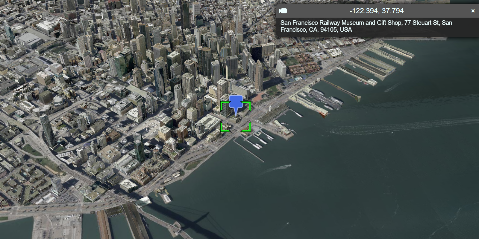
In the input box, type "Ferry building San Francisco" and then click the Geocode button to find its location. If a location is found, the map will zoom to it and display a pop-up with the address.

What's next?

Learn how to use additional ArcGIS location services in these tutorials:
Your browser is no longer supported. Please upgrade your browser for the best experience. See our browser deprecation post for more details.