The Display Order widget defines the rules for mosaicking and displaying overlapping images. A mosaic is a combination or merge of two or more images. You can use the widget to create a mosaic from an ArcGIS imagery layer with a mosaic dataset.

Six adjacent images are mosaicked together into one image.
In many cases, input raster images overlap. This means that you can create different mosaics from the same group of input raster images depending on how you want to handle the overlapping areas.
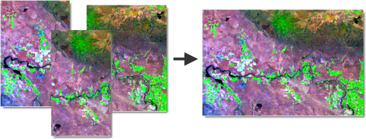
A mosaic is created from overlapping input images.
The widget uses mosaic methods to sort overlapping images, and mosaic operators to display sorted images on the fly.
Examples
Use this widget to support app design requirements such as the following:
-
You want to display certain images from an image collection.
-
You want to define image display order based on values in an attribute field.
-
You want part of a mosaic where two images overlap to display the average pixel values of two images that overlap in a mosaic.
Usage notes
This widget requires connection to a Map widget. The Map widget must contain a web map or web scene with at least one imagery layer.
When you include this widget in an app, a panel provides users with the following interaction options:
-
Use the drop-down menu to select a supported imagery layer from the connected map or scene.
-
Mosaic method—Choose a mosaic method. The mosaic method defines how the widget creates a mosaic from the input images. For example, the By attribute method orders images based on a field from the attribute table. When None is used, the widget creates the mosaic using the order of the images in the attribute table. Mosaic methods appear in the drop-down menu if they are allowed in the imagery layer.
Depending on which mosaic method you choose, you are prompted to enter inputs such as an attribute, highest priority value, or image ID.
-
Mosaic operator—Choose a mosaic operator. The mosaic operator defines how to apply a mosaic method. The widget uses mosaic methods and mosiac operators to resolve overlapping cells in the mosaic. Different mosaic methods support different mosaic operators.
Learn more about mosaic methods and mosaic operators in ArcGIS Pro documentation
Settings
The Display Order widget includes the following settings:
-
Select a Map widget—Select a Map widget. A drop-down menu lists all of the Map widgets in the app. The Display Order widget connects automatically to the first map on the current page.
-
If you connect a Map widget, any connected maps or scenes appear in a list in the widget settings. Click the Select layers button
 to open the Select layers panel, where you can turn on Customize layers.
 -
-
The following behaviors apply when you turn on Customize layers:
-
You can choose which imagery layers to connect to the Display order widget.
-
If you add or remove layers from the map or scene at run time, those changes are not synced with the Display Order widget.
-
-
The following behaviors apply when you turn off Customize layers:
-
All supported imagery layers appear in the Display Order widget.
-
If you add or remove layers from the map or scene at run time, those changes are automatically synced with the Display Order widget.
-
-
-
Interaction options
This widget supports actions, which you can configure on the Action tab of the widget's settings.
Turn on data actions to add buttons to the widget's user interface for performing certain actions, such as panning and zooming to imagery on the map.