Build a Local Server deployment
For your deployed application to use Local Server functionality, you must create a Local Server deployment to include with your application.
The ArcGIS Maps SDK for Local Server installation includes all the components of Local Server that might be required during the development of your application. When deployed to production, your application may only need a subset of these components. Use the Local Server Deployment Builder to create a Local Server deployment directory that includes only the components that your application requires. This will reduce your application footprint. The Local Server Deployment Builder is included with the Local Server SDK. You can open it from the Windows Start menu or the Local Server SDK installation folder, for example on Windows C.
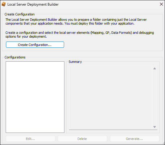
To create a new configuration:
- Click Create Configuration to start the process.
- On the
Deployment Configurationdialog, enter a name for your configuration and click OK. - The deployment builder will then automatically display the Local Server
Deployment Settingsdialog where you can configure the components required for your application to successfully execute all functionality that requires Local Server. - When you have finished selecting the required sub-components of Local Server, click OK to return to the Local Server Deployment Builder dialog.
- When you are ready to create the deployment, in the Configurations list select the Configuration you just created then click Generate....
- On the next dialog, titled
Deployment Locationyou must specify, or browse for, a folder path for the output location of your Local Server deployment, then click OK. - Finally, the
Summarydialog displays the name of your configuration and its output location, along with your selected deployment options and their estimated size on disk. - Click OK to proceed with generating the Local Server deployment.
You can make this Local Server deployment directory available to your application in one of the following ways:
- Copy the generated Local Server deployment directory adjacent to your application executable file. By default the API will search for a Local Server deployment directory in this location before defaulting to the SDK installation location.
- Copy the generated Local Server deployment directory to an alternative location and define the install path for the Local Server using the
Localmethod. Ensure the Local Server deployment directory is deployed to that location as part of the application installation.Server. INSTANC E.set Install Path("c :/my Local Server Install");
Local Server components
| Deployment Component | Description |
|---|---|
ArcGIS Pro Compatible Server (Pro) | This is required if your application uses any local services. |
Microsoft C and C++ Runtime Libraries (Pro) | Including Microsoft VC++ libraries in the runtime deployment following the app-local pattern allows for X style deployments. Only include these if your setup is not installing the Microsoft Visual C++ redistributable packages. |
Geoprocessing (Pro)Available sub-packages:
| Provides the ability to perform geoprocessing tasks via geoprocessing packages. For a list of supported tools, refer to the Supported geoprocessing tools topic. |
Python Scripting (Pro) | Provides the ability to use Python scripts in geoprocessing or labeling. |
Additional Data Formats (Pro)Available sub-packages:
| Provides additional vector file data format and raster file data format support. Enable the appropriate packages for the formats your application needs to support. |
Additional Projection Engine Transformations (Pro) | Adds additional projections and geotransformations. For more information on coordinate systems, refer to the Spatial references topic. |
Debug (Pro)Available sub-packages:
| Supports debugging of your deployed app. Should be used for testing only, and not included in your final app deployment. |