Learn how to create a tiled imagery layer image service using your own imagery data in ArcGIS Online.

Tiled imagery layers are image services built from one or multiple image files. When multiple images are used, they are mosaicked together to form a seamless single image. These layers are divided into pre-rendered tiles to improve performance allowing efficient access and display in web maps. This structure is optimized for fast, scalable map rendering and is ideal for static visualizations that do not require dynamic processing.
In this tutorial, you will use data management tools to upload your imagery files and create an image service.
Prerequisites
-
Before you begin, you need an ArcGIS account for ArcGIS Online.
-
Optional: Your own collection of raster data (e.g., satellite imagery, drone imagery, or aerial photography)
Steps
Download the data
For this step, you will use the North Carolina imagery data. The imagery was downloaded from the NOAA Data Access Viewer.
- In your web browser, go to the North Carolina Public Imagery item.
- Click Download to download the zip file locally.
- Unzip this file on your machine.
Sign in

In this step, you will sign in to your portal and create an Imagery layer item type.
- Sign in to your portal's organization.
- Click Content > New item > Imagery layer.
Get started

In the Create imagery layers tool, you will select Tiled Imagery Layer to create a tiled imagery layer from multiple image files. The Source image files wil be converted to Cloud Raster Format (CRF) when uploaded to your portal's organization.
- Choose Tiled Imagery Layer.
- Click Next.
Configure the layer

In this step, you will create a mosaicked image for your image service. This will allow you to add multiple images to the service.
- Choose One Mosaicked Image.
- Click Next.
Define imagery

In this step, you will define a raster type and upload your imagery.
- Choose Raster Dataset.
- Click Browse to select the North Carolina images stored on your machine.
- Click Next.
Set item details
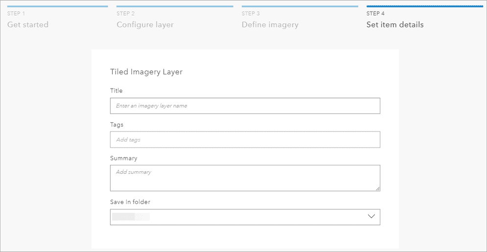
In this step, you will set the details of the image service.
- Set the item details for your image service:
- Title: Give your image service a descriptive title.
- Tags: Add relevant keywords for easy discovery.
- Summary: Provide a brief description of the imagery.
- Save in folder: Provide a location for your service.
Publish the Service
- Review all settings and configurations.
- Click Create to create your image service.
Once the image service is created, you will be navigated to the item details page of the service allowing you to enter additional information. You can also click on the Map Viewer or Scene Viewer in the item details page to view your image service.
What's next

Create a dynamic imagery layer
Use data management tools to create a new dynamic imagery layer image service.

Create a vector tile service
Use data management tools to create a new vector tile service from a feature service.

Create a map tile service
Use ArcGIS Online or scripting APIs to publish a map tile service.